As things get a bit more active across the tropical Atlantic, I wanted to take some time and offer a complete breakdown for everyone. This will – hopefully – give you a complete picture as to what to expect in the coming days and weeks.
First things first, though, here is the tropical update video:
And a look at the latest from the National Hurricane Center…

The big picture
There are a few ridges of high pressure plants across parts of the northern hemisphere steering tropical systems from Africa west toward the United States. This is pretty typical for this time of the year.

There are some weaknesses within these ridges, too. Also typical. The space between the two out in the Atlantic may allow Tropical Storm Rene to sneak north before making it across the Atlantic. While Paulette rides around the western ridge and passes by Bermuda.
Here is a look at that same map, in motion:
Generally, when tropical waves come off the coast of Africa, they will travel along the ITCZ, the Inter-Tropical Convergence Zone, toward the west until they develop a strong enough area of low pressure to feel the tug of Coriolis and slide north toward the North Pole.
Right now, the only two areas organized enough to feel that tug would be Tropical Storm Paulette and Tropical Storm Rene. You can see evidence of that on the infrared imagery.

The two tropical storms are the only areas in the Atlantic with enough convection and organization at the current time to feel that pull toward the Pole.
Currently, the upper-level pattern is beating up Paulette and Rene.
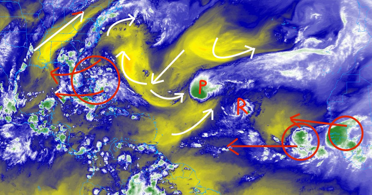
That same shearing will likely keep Paulette moving more easterly than northeast in the next 72 hours and may – simultaneously – allow Rene to slide north.
The two waves closer to the United States Will be ushered across the Gulf. The wave that is currently in the Gulf will likely slide into Texas or Mexico with little fanfare. While the wave currently near the Bahamas may actually have a chance to develop into a Tropical Depression.

The biggest limiting factor for both of these areas will be time. They just may not have enough time in the Gulf, away from everything else, to get situated, oriented, and organized.
From the NHC
Here is the latest thinking from the National Hurricane Center on the tropical waves…
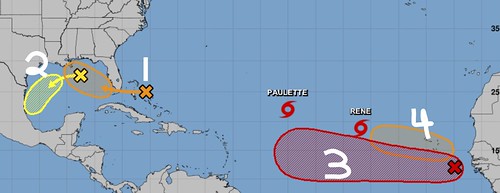
1. A large area of disorganized showers and thunderstorms extending from near the Central and Northwest Bahamas eastward over the western Atlantic for a few hundred miles is associated with a surface trough of low pressure. This system is forecast to move westward, crossing the Bahamas and Florida on Friday and moving into the eastern Gulf of Mexico over the weekend. Upper-level winds are expected to become conducive for development, and a tropical depression could form while this system moves slowly west-northwestward over the eastern Gulf of Mexico early next week. Regardless of development, this system is expected to produce locally heavy rainfall over portions of South Florida and the Keys during the next couple of days.
* Formation chance through 48 hours…low…10 percent.
* Formation chance through 5 days…medium…50 percent.
2. Another trough of low pressure is located over the north-central Gulf of Mexico. Although the associated shower and thunderstorm activity has diminished since earlier today, some slow developmentof this system is possible while it moves westward and then southwestward over the northern and western Gulf of Mexico through early next week.
* Formation chance through 48 hours…low…10 percent.
* Formation chance through 5 days…low…20 percent.
3. A tropical wave is located a few hundred miles southeast of the Cabo Verde Islands and is producing a large area of disorganized showers and thunderstorms. Gradual development of this system is forecast, and a tropical depression is expected to form within the next few days while the system moves generally westward across the eastern and central tropical Atlantic.
* Formation chance through 48 hours…medium…60 percent.
* Formation chance through 5 days…high…90 percent.
4. Another tropical wave is forecast to emerge off the west coast of Africa this weekend. Environmental conditions are expected to be conducive for development, and a tropical depression could form over the far eastern tropical Atlantic early next week while the system moves slowly westward.
* Formation chance through 48 hours…low…near 0 percent.
* Formation chance through 5 days…medium…40 percent.
Model data
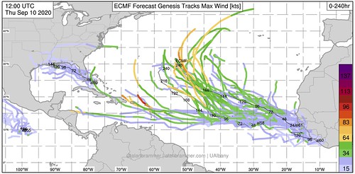
Pulling data from Alan Brammer’s site, it shows that the Ensemble models – both the GFS and Euro – show some sort of development with the waves coming off the African Coast. But they do differ when it comes to the waves closer to home.
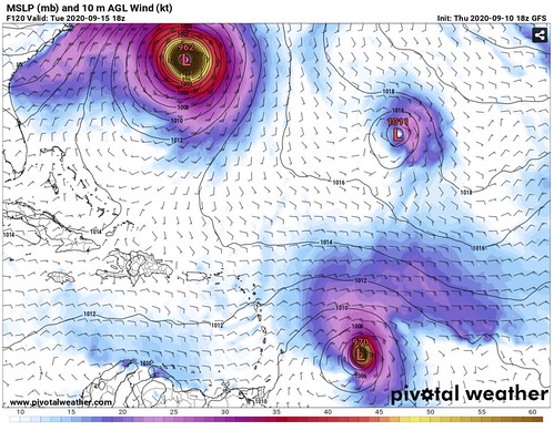
The Euro Ensembles takes the wave near the bahamas across the peninsula of Florida and runs it toward the northern Gulf Coast. The GFS isn’t really all to excited that the cluster of storms even exists. The difficult part about forecasting for situations like this is getting the model data to even “see” that this stuff is out there.
I tend to think model guidance will get much better in the coming 24 hours once this area gets a bit more thunderstorm activity.
The other area of interest in the Gulf is likely to slide across the Gulf without much consequence. There is some dry air to the north and a lot of the thudnerstorm activity is currently diurnally based. And until that changes, I don’t think much will become of this cluster in the Gulf.
Looking further out, based on the latest guidance from the GFS, the wave that recently emerged from the African coast, now pegged Invest 95L, will beat near the Greater and LEsser Antilles in 120 hours (five days).
That lines up with what the European data is suggesting, too.
Beyond that point, though, model guidance tend to diverge. The Euro takes the system north and keeps it mostly out to sea. The GFS slides it along a very Laura-like track for another three days toward the Gulf of Mexico.
The Bottom Line
There are a few waves to watch, nothing that is threatening the United States – or anywhere, truly – with potential hurricane conditions any time soon. However, there are a few things to keep on your radar, so to speak, during the next few days.
Wave 1 – As this one gets into the Gulf it will be important to track how close the center – if one forms – is to land and how slowly it moves. The longer it is over the open waters, the better the chance is that it develops into a Tropical Depression. Either way, the main threat with this system is likely going to be heavy rain and gusty wind for the Bahamas, Florida, Georgia and Alabama. Perhaps Mississippi and Louisiana, too.
Wave 2 – This one isn’t likely to do much more than bring a better shot for rain to areas along and near the Gulf Coast during the next five days as it drifts from Florida to Texas.
Wave 3 (Invest 95L) – This wave has the best chance of development in the coming days. And the speed that is develops will likely dictate the track and how far west it makes it before it starts to shift to the north. The sooner it develops, the sooner it will turn north. It will also be worth watching the ridges of higher pressure to the north as they interact with Paulette and Rene. As that may eventually change how this wave, Invest 95L, behaves.
Wave 4 – A bit of a wildcard at this point, but most guidance take this system to the north pretty quickly behind Rene.
Tropical Storm Paulette – This storm appears to be headed toward Bermud as we head into next week. Folks across the island will need to continue to monitor this system for impacts. The final track of this system will be dictate by the area of high pressure nearby and how soon Paulette runs into the front that is pegged to slide through early next week.
Tropical Storm Rene – This one is also a bit of a wildcard. I mentioned the other day that this thing may end up floating around out in the Atlantic for a while and so far, most model guidance agrees. This may need to be monitored in the future more, but for now is still going to be moving based on teh whims of the amtosphere out int eh ocean, bothering the fish and the ships.


