It is a busy day for the meteorologists of the National Hurricane Center. There are still six areas of interest in the tropical Atlantic. Two close to the United States, two out over the open waters, and two coming off the coast of Africa.

Tropical Storm Paulette and Tropical Storm Rene continue to swirl around in the open waters, but Paulette may eventually become a problem for the island of Bermuda. One of the waves coming off the African coast, Invest 95L, has a pretty good chance of development in the next 48 hours. Another disturbance, near the Bahamas, Invest 96L, has a decent shot of development through the weekend and into next week.
The other two areas are worth monitoring, but likely won’t require as much attention as one may never develop and the other is likely headed out to sea.
A quick breakdown from the NHC

1 – Invest 96L – 1. Updated: Shower and thunderstorm activity located over the northwestern and central Bahamas and the adjacent waters continues
to shows signs of organization. In addition, surface observations indicate that pressures have fallen over the area since yesterday and, along with wind data, suggest that a broad area of low pressure could be forming between the northwestern Bahamas and South Florida. This system is forecast to move westward at about 10 mph, crossing the Bahamas and Florida today and tonight and moving into the eastern Gulf of Mexico on Saturday. The disturbance could become a tropical depression while it is near South Florida tonight, but it is more likely to become a tropical depression while it moves slowly west-northwestward over the eastern Gulf of Mexico this weekend and early next week. Regardless of development, this system is expected to produce locally heavy rainfall over portions of the Bahamas, South Florida, and the Florida Keys during the next couple of days, and interests there, as well as along the northern and eastern Gulf coast, should monitor its progress.
* Formation chance through 48 hours…medium…60 percent.
* Formation chance through 5 days…high…70 percent.
2 – Disturbance in Gulf – Another trough of low pressure is located over the north-central Gulf of Mexico. Although the associated shower and thunderstorm activity is currently minimal, some slow development of this system is possible while it moves westward and then southwestward over the northern and western Gulf of Mexico through early next week.
* Formation chance through 48 hours…low…10 percent.
* Formation chance through 5 days…low…30 percent.
3 – Invest 95L – A tropical wave is located a few hundred miles south of the Cabo Verde Islands and is producing a large area of disorganized showers and thunderstorms. Development of this system is forecast, and a tropical depression is expected to form within the next few days while the system moves generally westward at 15 to 20 mph across the eastern and central tropical Atlantic.
* Formation chance through 48 hours…high…70 percent.
* Formation chance through 5 days…high…90 percent.
4 – Disturbance coming off Africa – Another large area of disturbed weather associated with a tropical wave is beginning to move off the west coast of Africa. Environmental conditions appear conducive for development during the next few days, and a tropical depression could form over the far eastern tropical Atlantic early next week while the system moves slowly westward. Upper-level winds could become less conducive for development by Monday or Tuesday.
* Formation chance through 48 hours…low…10 percent.
* Formation chance through 5 days…medium…40 percent.
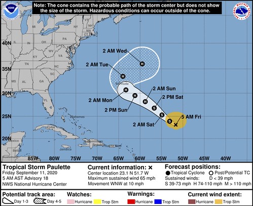
Tropical Storm Paulette – At 500 AM AST (0900 UTC), the center of Tropical Storm Paulette was located near latitude 23.1 North, longitude 51.7 West. Paulette is moving toward the west-northwest near 10 mph (17 km/h). A motion toward the northwest is expected for the next few days. On the forecast track, the center of Paulette should approach Bermuda Sunday night and Monday.
Maximum sustained winds are near 65 mph (100 km/h) with higher gusts. Little change in strength is expected today. Gradual strengthening is expected to begin tonight or on Saturday, and Paulette is forecast to become a hurricane this weekend.
Tropical-storm-force winds extend outward up to 205 miles (335 km) from the center.
The estimated minimum central pressure is 991 mb (29.27 inches).
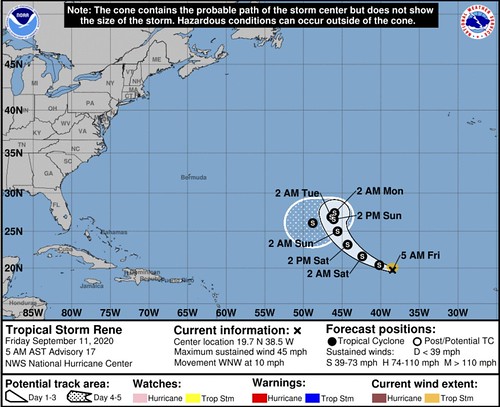
Tropical Storm Rene – At 500 AM AST (0900 UTC), the center of Tropical Storm Rene was located near latitude 19.7 North, longitude 38.5 West. Rene is
moving toward the west-northwest near 10 mph (17 km/h). This general motion is expected to continue through Friday night, followed by a turn toward the northwest on Saturday. A north-northwestward and northward motion with a decrease in forward speed is forecast Sunday and Sunday night.
Maximum sustained winds are near 45 mph (75 km/h) with higher gusts. Gradual strengthening is forecast during the couple of days. Afterward, weakening is expected to begin by Sunday night.
Tropical-storm-force winds extend outward up to 70 miles (110 km) from the center.
The estimated minimum central pressure is 1002 mb (29.59 inches).
Health check

It looks like Paulette is looking pretty healthy, despite the not-as-favorable environment it is battling through. Rene continues to be so small that the convection with it bounces up and down daily. Both Invests are collecting convection and continuing to look better. The other two areas aren’t as healthy looking.

Notice that the dry air surrounding Paulette doesn’t seem to be bothering the internal structure, while it has nearly eviscerated Rene. Both Invests are in favorable environments for further development and organization. The other two waves are still TBD.
Model Data
Tropical Storm Paulette
Before I get into the model data, here is a look at the official forecast for Paulette from the NHC:
The official forecast lines up pretty closely with the model data for the track for Paulette. Many of the global spaghetti plots follow down the center of the forecast cone. The GFS ensemble data shows a little more spread within the data, but that is what it is supposed to do.
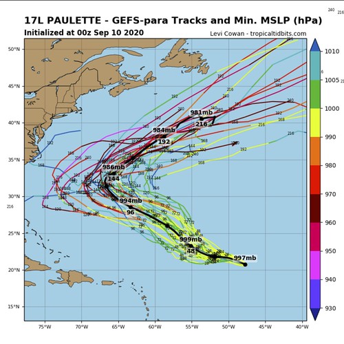
Bermuda, for those concerned, is right in the middle of the spread. So, there is a very good chance that Bermuda is impacted – wether directly or indirectly – by Paulette.
The current forecast is for Paulette to have wind around 100mph as it approaches Bermuda in about 72 hours. Model data supports this.
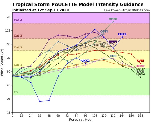
Most model guidance shows Paulette with wind between 80mph and 105mph.
Tropical Storm Rene
Before I get into the model data, here is a look at the official forecast for Paulette from the NHC:
Model guidance for Rene is a little tougher to work with as the models have a difficult time “finding” a storm that is so small and is constantly going up and down in intensity.
A prime example of this is within the same GFS Ensemble model that was used above for Paulette. For Rene, it looks like a 3-year-old drawing spaghetti
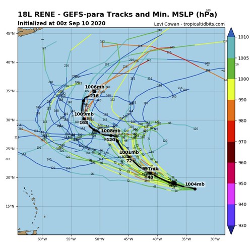
The reason it looks like that is because the model doesn’t have much to “latch on to” to make a forecast. That also means the intensity forecast data may be equally as meaningless.
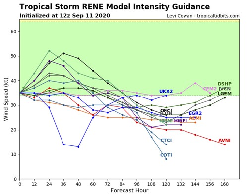
I’ll take this all with a grain of salt until Rene shows signs of holding it self together better.
Invest 95L
It is still a little too early in the game to talk about intensity forecasts for Invest 95L. This would become “Sally” if it were to strengthen into a Tropical Storm. But we can get an idea about where it may go from the same GFS Ensemble data.

Then again, maybe not.
Again, because this is so early in the game with this wave and due to its proximity to the other wave right behind it, the models have a difficult time grabbing a hold of a “center” to build a plot from, and without that defined center, you can end up with some unreliable data.
Invest 96L
I’m actually not going to share any model data for Invest 96L because it is still too early for this one, too. I know this one is the closest to “home” so I want to still offer some information – it just won’t look like the other data shown.
This is a look from the deterministic European model at where the data shows Invest 96L may be by Monday morning – compared to where it is now.
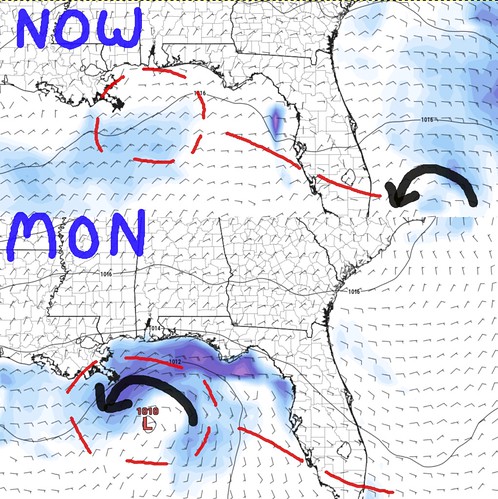
The black arrow highlights the circulation at the surface, the red lines show the potential track.
The GFS deterministic model shows a similar track. Both have this as a tropical depression – if that – by Monday and then making “landfall” on Tuesday. Landfall is in quotes because it is shown as a reasonably disorganized cluster of storms as it does so.
But, as everyone is well-aware, intensity modeling is not something that the models do well with systems that are not wrapped up and formed yet. And even then, th models still struggle at times. So it is important to keep tabs on this little cluster through the weekend and into next week.
The other two waves
We can probably wait and see with these other two waves for a bit.
The Bottom Line
While the jury is still out on the “other two waves” Invest 96L will likely mean extra rain for the Gulf Coast states – whether it is a Tropical Depression, Tropical Storm or just a cluster of thunderstorms. The Weather Prediction Center is showing between 2″ and 8″ of rain for some places along the Louisiana, Mississippi, Alabama, and Florida coasts.
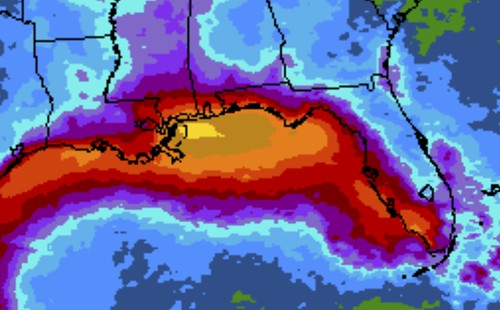
Now if further development occurs, then additional threats would be added to the list. But for now rain is the main concern through the next few days from Invest 96L.
Looking out into the Atlantic at Invest 95L, that will need to be monitored in the coming days and the track during the next 72 hours will likely dictate how much the Gulf Coast needs to worry. The longer it waits to develop and slide along a more northerly track, the more closely it will need to be tracked. But that system is still about 10 days away from the Gulf of Mexico if – and that is still a big if – it makes it there.


