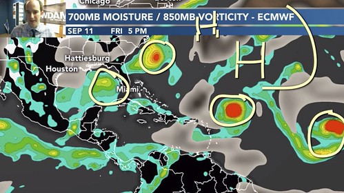
Tropical Depression 19 formed Friday and with the close proximity to Florida and the Gulf immediately grabbed everyone’s attention. For those who have been tracking everything in the tropics, you had an early warning about this system all the way back on September 3rd during one of the tropical update videos.
While the Euro didn’t “nail” this one, it was highlighting the chance something may try to sneak into the Gulf
This is still a pretty fluid situation since Tropical Depression 19 just formed and the Hurricane Hunters haven’t flown a plane into the thing yet. But there are weather balloons that are launched down in south Florida, so the atmosphere near Tropical Depression 19 is being sampled a bit. So I think some of the 00z model data should carry some weight.
So let us dive into everything….
Right Now
Here is a look at the infrared imagery from the GOES-16 Satellite. It shows some robust convection forming around the center.
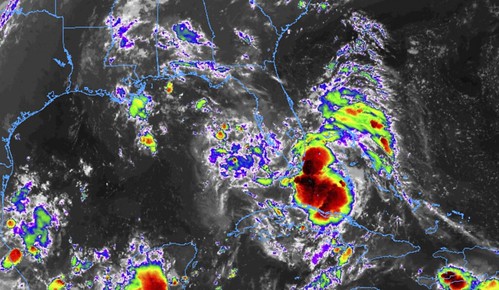
A lot of times, convection on tropical systems can explode overnight. This has been noted in a lot of meteorological research, sure. But this trend can be seen pretty easily by just watching these system over the past few years really take off – at times – during the overnight hours.
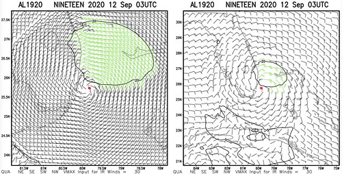
You can see on the wind estimates that most of the strongest wind is relegated to the northern side of the system right now.
Over on the water vapor imagery, I’ve labeled a lot of the features worth noting.
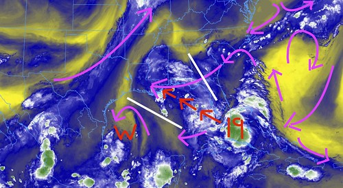
The magenta lines are the mid-level winds, the red arrows indicate the forecast track from the NHC and the white lines are the “fences” where the system – given the background flow – is most likely to travel.
You can see that the overall pattern across the region is pretty chaotic. There are a few areas of low pressure, a few areas of high pressure and some dry areas and moist spots. It isn’t quite as straightforward as when Marco and Laura were in the Gulf.
Right now, though, it looks like the most likely gateway out of the Gulf pushes it toward landfall along the northern Gulf Coast
Where specifically? We don’t know that yet. But the data does have some suggestions…
From the NHC
Before we get into any model data,though, I want to start with the latest from the National Hurricane Center…
SUMMARY
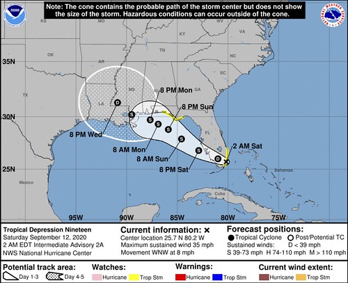
LOCATION…25.7N 80.2W
ABOUT 10 MI…15 KM SSE OF MIAMI FLORIDA
MAXIMUM SUSTAINED WINDS…35 MPH…55 KM/H
PRESENT MOVEMENT…WNW OR 295 DEGREES AT 8 MPH…13 KM/H
MINIMUM CENTRAL PRESSURE…1007 MB…29.74 INCHES
DISCUSSION AND OUTLOOK
At 200 AM EDT (0600 UTC), the center of Tropical Depression Nineteen was located near latitude 25.7 North, longitude 80.2 West. The depression is moving toward the west-northwest near 8 mph (13 km/h) and this motion with a decrease in forward speed is expected during the next few days. On the forecast track, the center of depression is forecast to move inland over south Florida during the next hour or so, move over the southeastern Gulf of Mexico later today, and then move northwestward over the north-central Gulf of Mexico on Monday.
Maximum sustained winds are near 35 mph (55 km/h) with higher gusts. Little change in strength is likely while the center crosses the Florida Peninsula today. It is expected to become a tropical storm tonight or Sunday over the Gulf of Mexico and gradually intensify through Monday. A wind gust of 41 mph (66 km/h) was recently reported at the University of Miami Rosenstiel School campus on Virginia Key, Florida.
The estimated minimum central pressure is 1007 mb (29.74 inches).
HAZARDS AFFECTING LAND
WIND: Tropical storm conditions are possible within the watch area in south Florida overnight and early Saturday. Tropical storm conditions are possible in the watch area in the Florida Panhandle by Sunday night.
RAINFALL: Tropical Depression Nineteen is expected to produce total rainfall accumulations of 1 to 3 inches with isolated maximum amounts of 5 inches across central and southern Florida, including the Florida Keys through Sunday. This rainfall may produce isolated flash flooding and prolong high flows and ongoing minor flooding on rivers across Central Florida. Total rainfall accumulations of 2 to 4 inches with isolated maximum amounts of 6 inches is expected across the western Florida Panhandle. This rainfall could produce isolated flash flooding.
SURF: Swells are expected to spread northward along the west-central coast of Florida and the Florida Panhandle during the next couple of days. These swells are likely to cause life-threatening surf and rip current conditions. Please consult products from your local weather office.
FORECAST POSITIONS AND MAX WINDS
INIT 12/0300Z 25.7N 79.8W 30 KT 35 MPH
12H 12/1200Z 26.0N 81.0W 30 KT 35 MPH…INLAND
24H 13/0000Z 26.8N 82.9W 35 KT 40 MPH
36H 13/1200Z 27.9N 84.6W 40 KT 45 MPH
48H 14/0000Z 28.8N 85.9W 45 KT 50 MPH
60H 14/1200Z 29.3N 86.9W 55 KT 65 MPH
72H 15/0000Z 29.7N 87.7W 60 KT 70 MPH
96H 16/0000Z 30.2N 89.5W 60 KT 70 MPH…INLAND
120H 17/0000Z 31.3N 90.9W 25 KT 30 MPH…INLAND
KEY MESSAGES
1. Heavy rainfall is expected to produce isolated flash flooding over portions of central and southern Florida and prolong existing minor river flooding across central Florida.
2. Tropical storm conditions are possible overnight and early Saturday along the southeast Florida coast where a Tropical Storm Watch is in effect. Tropical storm conditions are possible by Sunday night in portions of the Florida Panhandle, where a Tropical Storm Watch has been issued.
3. The system is forecast to strengthen to near hurricane intensity by early next week as it moves across the northeastern Gulf of Mexico. Dangerous impacts from storm surge, wind, and heavy rainfall will be possible along the Gulf Coast from the Florida Panhandle to southeastern Louisiana late this weekend and early next week. Residents in these areas should monitor the progress of this system and updates to the forecast, as Storm Surge, Tropical Storm or Hurricane watches could be issued on Saturday.
Model data
When looking at the forecast data, I know everyone wants to see the spaghetti models. They are a quick and easy way to get a good idea about where a system may head. But there are some “under the hood” things you may be interested to look at first, to give you a better idea about which spaghetti model – or cluster of models – is more likely to be accurate.
Sure, I could simply tell you which one is which, but what is the fun in that?!
First thing I want to show is the 500mb vorticity map from the 00z GFS for Monday afternoon. The big red splotch just off of the Mississippi and Alabama coast is Tropical Depression 19 – likely a Tropical Storm by that point.
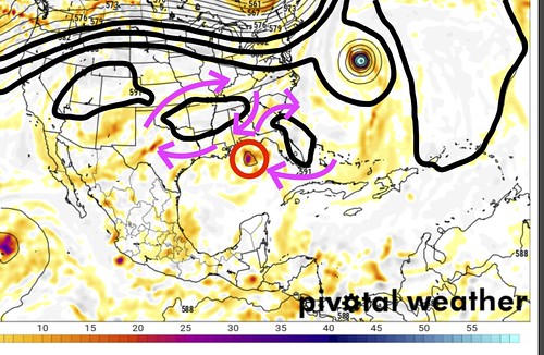
The black lines (some of which I’ve made thicker to showcase where they are) are something called geopotential heights. And while I won’t spend time right now breaking that down, just know that these lines are equal lines of air pressure and can usually give you a good estimation of wind direction (the air follows the lines) and speed (the close the lines are together, the stronger the wind).
I’ve added in the magenta arrows again to show which direction the wind is moving.
Notice that by Monday afternoon the wind near Tropical Depression 19 is going to pushing and pulling at it. Perhaps nearly equally at times. That means the “current” involved with “steering” the storm will become almost balanced out according to this model run. That is why the forecast from the NHC is for Tropical Depression 19 to slow down as it approaches land. The wind that is steering it doesn’t really steer it much anymore.
This slowing is reflected in most of the models used in the spaghetti plots, too.
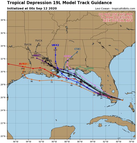
Notice that the lines show a “48 hour” tick just south of Panama City, meaning that by Sunday night it will be (pretty far south) off the coast of Panama City. But it takes another 48 hours for it to move from that point to near New Orleans.
This could be a problem. Because a slow moving system over the open waters of the Gulf of Mexico is likely to do two things: strengthen and rain.
Intensity forecasts this early in the game are likely not worth much. But I wanted to share this one.
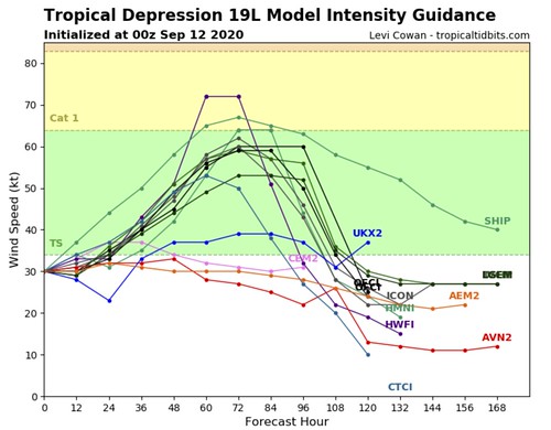
Notice that there is some strengthening through the next 48 hours, but then it continues to strengthen and plateaus and the holds there for nearly 24 hours in some of the guidance. That is likely an indication that the system is stalled out near land, but still over water. We can estimate this because if it were on land, it would be weakening. And if it were fully over water, it would likely continue to strengthen given the favorable environment.
But in this case, it will be close to land, so ithe models suggest it should – should is the key word – be more difficult for Tropical Depression 19 to continue to strengthen.
It is interesting to note, though, that the SHIPS model does peg Tropical Depression 19 with a 20-percent chance of Rapid Intensification during the next 72 hours.

That would put it as a Category 1 or even Category 2 Hurricane near the Louisiana / Mississippi / Alabama coastline in 72 hours.
Not a “big” chance. But also not small, either. The chances are still more than 3.5 times higher than the climatological average.
What does this mean for where I live, Nick?
That is a great question. It depends. Specifics aren’t really possible to offer at this point, but generalities can be estimated.
Florida peninsula
1. Heavy rainfall is expected to produce isolated flash flooding over portions of central and southern Florida and prolong existing minor river flooding across central Florida.
2. Tropical storm conditions are possible overnight and early Saturday along the southeast Florida coast where a Tropical Storm Watch is in effect.
Florida panhandle
1. Heavy rainfall is expected to produce isolated flash flooding from Tallahassee back to the west.
2. Tropical storm conditions are possible by Sunday night in portions of the Florida Panhandle, where a Tropical Storm Watch has been issued.
3. The system is forecast to strengthen to near hurricane intensity by early next week as it moves across the northeastern Gulf of Mexico. Dangerous impacts from storm surge, wind, and heavy rainfall will be possible along the Gulf Coast from the Florida Panhandle late this weekend and early next week. Residents in these areas should monitor the progress of this system and updates to the forecast, as Storm Surge, Tropical Storm or Hurricane watches could be issued on Saturday.
Lower Alabama
1. Heavy rainfall is expected to produce isolated flash flooding.
2. Tropical storm conditions are possible by Monday and Tuesday, but not likely at this point. Continue to monitor future forecasts for more information.
3. The system is forecast to strengthen to near hurricane intensity by early next week as it moves across the northeastern Gulf of Mexico. There is a chance that tropcial storm force wind may be relegated to closer to the coastline and inland areas may not see as strong of wind.
South Mississippi
1. Heavy rainfall is expected to produce isolated flash flooding, despite recent dry conditions. Up to 10 inches of rain may be possible in some locations.
2. Tropical storm conditions are possible. particularly closer to the coastline.
3. The system is forecast to strengthen to near hurricane intensity by early next week as it moves across the northeastern Gulf of Mexico. Please stay tuned for future forecasts.
Southeast Louisiana
1. Heavy rainfall is expected to produce isolated flash flooding, despite recent dry conditions. Up to 10 inches of rain may be possible in some locations.
2. Tropical storm conditions are possible. particularly closer to the coastline.
3. The system is forecast to strengthen to near hurricane intensity by early next week as it moves across the northeastern Gulf of Mexico. Please stay tuned for future forecasts.
Please know that this information may change. Perhaps drastically. So it is very important that you continue to check back for forecast updates.
The Bottom Line
If you live along the coastline between Morgan City, Louisiana and Pensacola, Florida. Or within 75 miles of the coast between those cities, please keep tabs on the forcause for future updates. The National Hurricane Center will continue to refine the forecast and the Hurricane Hunters will likely be flying into the system during the next 24 to 48 hours to get more data and make the forecasts even more accurate.
But since this system formed so recently, there are still a fair amount of unknowns.


