It still looks like there is a potential for some severe weather on Wednesday. And it still looks like a long line of storms will drift through the area with heavy rain, lightning, gusty wind, small hail and the chance for a few tornadoes.
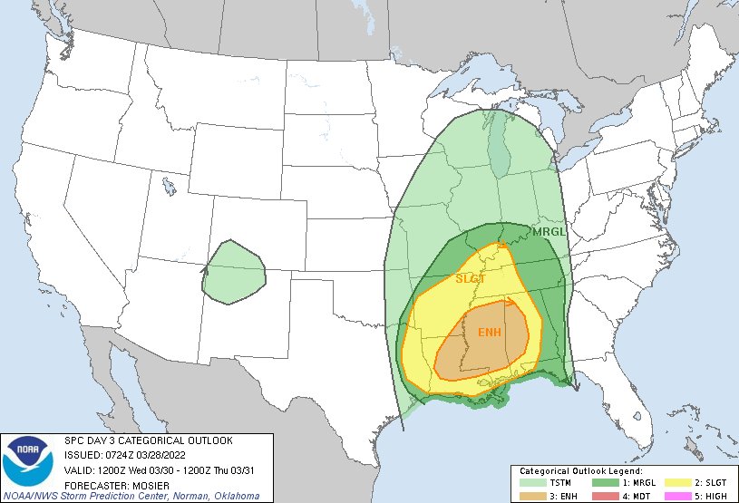
The Storm Prediction Center maintained the Enhanced Risk. That is a “3” on the 1-to-5 scale where “5” is the highest risk for the most significant severe weather. Last week the same region was under a Moderate Risk, or a “4” on the same scale.
Last week, though, was completely different setup. I’ll have more details on the potentials a bit later today. At this time, though, there haven’t been many big changes to the forecast from yesterday.


It still looks like showers and storms will move through the area during the afternoon and evening on Wednesday. And it still looks like they will be mainly confined to a squall line. And it still looks like the tornado threat will be confined to embedded supercells and bookend vortices.
From the SPC:
A convective line should be ongoing Wednesday morning, likely extending from the Ozark Plateau southwestward across eastern OK into northeast TX. This line is forecast to move eastward throughout the day, forced by the strong ascent attendant to the shortwave trough mentioned above.
The downstream air mass is expected to be moist, but not overly buoyant due to widespread showers/cloudiness and poor lapse rates across the warm sector. Even so, the very strong kinematic profiles will likely support an invigoration or intensification of the convective line as it moves eastward into the Lower MS Valley.
Primary threat with the line will be strong gusts, although embedded/QLCS tornadoes are possible as well. Potential exists for a well-organized convective line capable of significant wind gusts (i.e. at least 74 mph). The supercell/tornado potential ahead of the line is a bit more uncertain. While the kinematic profiles certainly support long-lived supercells capable of strong tornadoes, whether or not discrete development can organize within the warm sector remains questionable. The fast-moving character of the anticipated convective line will likely limit the duration of any warm sector development.
Additionally, warm mid-level temperatures across the warm sector could act to suppress deep convection. These uncertainties preclude introducing higher severe probabilities with this outlook.
Day to Day Forecast
Today
Mostly sunny. Highs in the mid 80s.
Tonight
Clear in the evening, then becoming partly cloudy. Patchy fog after midnight. Lows in the mid 50s.
Tuesday
Patchy fog in the morning. Mostly sunny. Highs in the lower 80s.
Tuesday Night
Mostly cloudy. Patchy fog after midnight. Breezy. Lows in the mid 60s. South winds around 10 mph with gusts up to 20 mph.
Wednesday
Mostly cloudy. Showers and storms likely in the afternoon/evening. Severe weather possible. Breezy with highs in the lower 80s. South winds 15 to 25 mph. Gusts up to 40 mph in the afternoon. Chance of rain 70-percent.
Wednesday Night
Showers with a chance of thunderstorms in the evening, then drying out after midnight. Locally heavy rainfall possible in the evening. Breezy with lows in the mid 50s. Chance of rain 70-percent.
Thursday
Sunny. Highs in the upper 70s.
Thursday Night
Mostly clear in the evening, then becoming partly cloudy. Lows in the upper 40s.
Friday
Partly sunny. Highs in the upper 70s.
Friday Night
Mostly cloudy. A chance of showers and thunderstorms after midnight. Lows in the mid 50s. Chance of rain 30-percent.
Saturday
Mostly cloudy with showers and storms possible. Highs in the mid 70s. Chance of rain 40-percent.
Saturday Night
Mostly cloudy with a 40-percent chance of showers. Lows in the lower 50s.
Sunday
Mostly sunny with a 20 percent chance of showers. Highs in the mid 70s.


