Hello everyone and happy Friday! After a dreary and rainy week, I wish I could say that the pattern would be moving towards more dry weather, however this does not seem to be the case with flooding still a lingering issue. As I’m sure many of you have personally experienced or read about from the other interns, the pattern of heavy rain has been detrimental to the area, with precipitation amounts approaching 10″+ in some areas.

On top of this, Nick posted about the brief tornado that occurred in Hattiesburg on Wednesday, which was an event that took a number of factors to line up just right. This has probably been the most wild week of weather that I’ve been through so far during this summer, and its a great way to close out my time here as an intern!
Moving on to the forecast, we are not out of the woods yet in terms of flooding, as we are still dealing with rain in the forecast for today.

Taking a look at the HRRR modeled reflectivity for this afternoon, we can see once again numerous scattered showers and thunderstorms popping up over the area. Like it has been the past few days, storms do have the potential to drop a lot of precipitation in a short amount of time, as precipitable water values are still high at above 2″.
With the ground being well saturated from the rainfall over the past week, any heavier rain shower does pose a risk for flooding, as the ground can only soak up so much rainfall. As a result, the NWS Jackson office does have flash flooding in their outlook for the day today.

As Isaiah pointed out yesterday, numerous amounts of the rivers in the area are approaching flood stages from minor to moderate. The rising rivers combined with the saturated ground makes flooding much easier even with just an additional 1-2″, meaning that it doesn’t take much to push things over the edge. It is important to be aware of any rainfall that occurs today as the term “flash flooding” really can come into play here with quick inundation of roadways and low lying areas.
With cloudy skies throughout the day, this will leave temperatures across southeast Mississippi and southwest Alabama into the low and mid 80s thanks to the persistent cloud cover and precipitation cooling down the temperatures.

As we begin to look into the pattern further out, unfortunately it looks like rainy weather is here to stay. When we take a look at the upper-level pattern for the beginning of the work week, we can pick out a few features that will point towards the continued chance for day-time showers and thunderstorms.

Looking at the 500MB heights and winds for Monday, we can see the Bermuda High just to the east of our area, putting us in a region of southerly flow off of the Gulf of Mexico. With this, moisture inflow will be continuous moving into next week, leading to day-time heating sparking scattered showers and thunderstorms.

With the overall flow over the area being southerly, precipitable water values will remain high (above 2″), meaning heavy showers and thunderstorms and likely to continue into the next week.
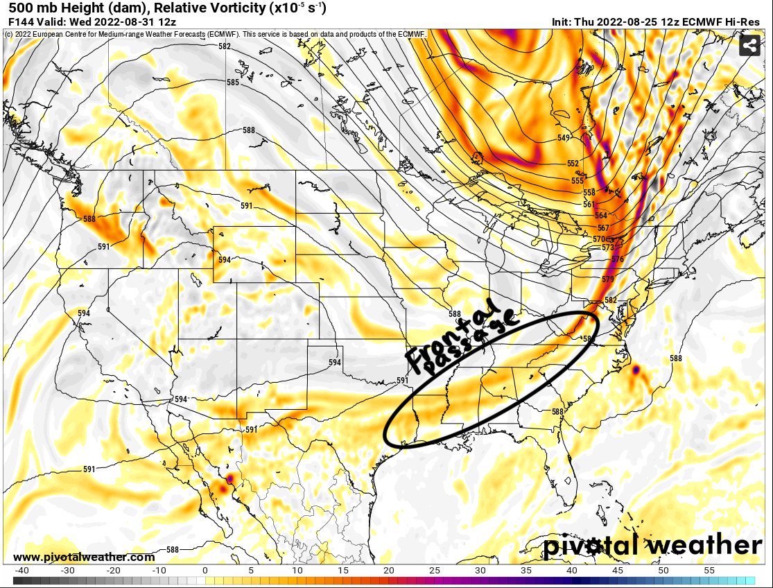
As we move a bit later into the week, some of the models disagree on the impact that an upper-level disturbance will have on our area.
Starting with the European solution, this shows our region experiencing a frontal passage, which would lead to lowered humidity values and lowering the chances for day-time showers and thunderstorms.
The GFS on the other hand, leaves a more cutoff low to our west just over Oklahoma, meaning our region stays humid and the likelihood for day-time showers and thunderstorms stays elevated with elevated precipitable water values.
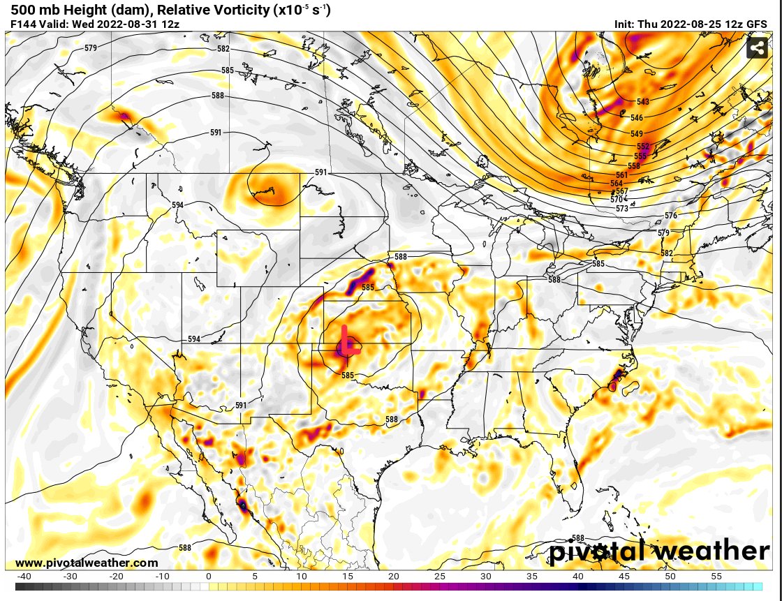
This will be sorted out as we get closer to the middle of next week, but hopefully the European solution plays out as this would give us more of a relief from the persistent excessive rainfall over the area.
Finally, as I began to allude to earlier in the post, these will be my last (two) posts on the site for this summer as I begin to transition back into school for my final year of undergrad. I wanted to say thank you to everyone for stopping by and reading these forecasts and for all of your support and kind words. Being able to really put all of my skills and knowledge to work was really something I enjoyed and I can’t thank Nick enough for this opportunity. I hope everyone has a great rest of the summer that’s left and continues to come back to the amazing posts Nick has to offer!
Day-to-Day Forecast
Today
Mostly cloudy with a 70-percent chance of afternoon showers and thunderstorms. Highs in the mid 80s. Wind south at 5mph.
Tonight
Mostly cloudy with a 30-percent chance of showers and thunderstorms. Lows in the lower 70s. Wind calm.
Saturday
Partly cloudy, with a 50-percent chance of showers and thunderstorms in the afternoon. Highs in the upper 80s. Wind southeast at 5mph.
Saturday Night
Partly cloudy with a 30-percent chance of showers and thunderstorms. Lows in the lower 70s. Wind calm.
Sunday
Mostly sunny with a 60-percent chance of showers and thunderstorms in the afternoon. Highs in the upper 80s. Wind south at 5mph.
Sunday Night
Mostly cloudy with a 30-percent chance of showers and thunderstorms. Lows in the lower 70s. Wind calm.
Monday
Partly cloudy with a 60-percent chance of showers and thunderstorms. Highs in the mid to upper 80s. Wind southeast at 5mph.
Monday Night
Mostly cloudy with a 30-percent chance of showers and thunderstorms. Lows in the mid 70s. Wind calm.
Tuesday
Mostly sunny with a 60-percent chance of showers and thunderstorms. Highs in the upper 80s. Wind south at 5mph.
Tuesday Night
Mostly cloudy with a 40-percent chance of showers and thunderstorms. Lows in the low-to-mid 70s. Wind calm.
Wednesday
Mostly sunny with a 60-percent chance of showers and thunderstorms. Highs in the upper 80s.
Wednesday Night
Mostly cloudy with a 40-percent chance of showers and thunderstorms. Lows in the lower 70s.
Thursday
Partly cloudy with a 50-percent chance of showers and thunderstorms. Highs in the mid 80s.
Thursday Night
Partly cloudy with lows in the lower 70s.


