We’ve got a soggy Saturday on deck for today. It won’t be constantly raining, but there will be on-and-off showers through the day to the point where outside activities will be rather damp.

The showers will continue through this evening and into the overnight hours. There is the slightest of slight chances that folks up around I-20 and off to the north may see some wayward ice crystal flurries overnight tonight and into tomorrow morning as all of this moves out.
Then our attention turns to midweek when the next chance for rain – and storms – shows up.

The sTorm Prediction Center has already highlighted our area with the potential for severe weather. PArts of the region have been pegged with a Slight Risk for severe weather on Thursday. That is a “2” on the 1-to-5 scale where “5” is the highest risk for the most significant severe weather.

If you’re thinking, “Golly, usually they sure are calling for this pretty early on!” You are right. It isn’t too often you see a “Day 6” forecast area. And they aren’t often this big, either. I think the last one was right before the pandemic.
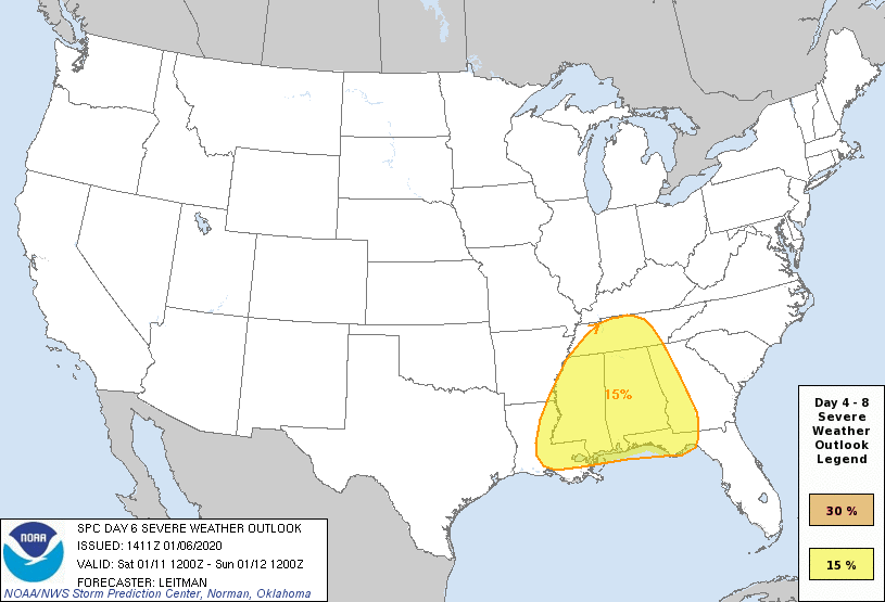
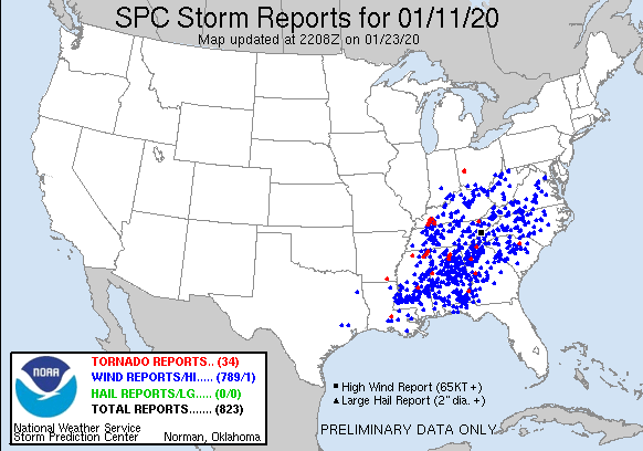
And that was a pretty significant event. But it was mainly a wind event. There were a few dozen tornadoes, but only a few were EF-2 or stronger. Most were EF-0 and EF-1 tornadoes.
So, sure, the last time was pretty robust. But that doesn’t mean this next time will be.
For this upcoming event, the timeline is still pretty wide. Storms could start as early as Wednesday afternoon and linger around as late as Thursday evening. That doesn’t mean it will be storming that long, but there will be the potential for a storm here or there to pop up based on the latest guidance.

But there is still a lot we don’t know about this event. So hang in there and keep checking back for updates.
What I do know is that by Friday, things clear out and we look good as we move into the weekend.
REGIONAL DAY TO DAY FORECAST
Today
Showers, cooler. Near steady temperature in the upper 40s. North winds 10 to 15 mph with gusts up to 25 mph. Chance of rain 90 percent.
Tonight
Mostly cloudy. Showers likely in the evening. Lows in the upper 30s. Northwest winds 15 to 20 mph with gusts up to 30 mph. Chance of rain 70 percent.
Sunday
Sunny. Not as cool with highs around 60. Northwest winds 10 to 15 mph with gusts up to 25 mph.
Sunday Night
Mostly clear. Lows in the mid 30s. Northwest winds 5 to 10 mph.
Monday
Sunny. Highs in the upper 60s. West winds around 5 mph.
Monday Night
Partly cloudy. Lows in the mid 40s.
Tuesday
Increasing clouds with a few isolated showers and storms possible. Highs in the lower 70s. Chance of rain 20 percent.
Tuesday Night
Mostly cloudy with showers and storms possible. Severe weather unlikely. Lows in the lower 60s. Chance of rain 40 percent.
Wednesday
Mostly cloudy with a chance of showers and storms. Highs in the mid 70s. Chance of rain 40 percent.
Wednesday Night
Cloudy with storms possible. Lows in the mid 60s. Chance of rain 40 percent.
Thursday
Showers and storms possible. Some severe.. Highs in the mid 70s. Chance of rain 70 percent.
Thursday Night
Mostly cloudy. A few lingering showers possible. Lows around 40. Chance of rain 20 percent.
Friday
Mostly sunny. Much cooler with highs in the lower 50s.


Thanks so much Nick!