It looks like we will see some more clouds today. And maybe even an isolated shower this evening.
As we head into the weekend there will be a chance for some showers here and there. Originally, it looked like most of the rain was going to stay to the south into the Gulf but now it looks like enough of it will sneak north and likely make Saturday a bit damp.
Severe weather isn’t expected. In fact, I don’t even know if anyone will catch a rumble of thunder, but there will be some light to moderate rain at times.
Enough to make for a Soggy Saturday.
And then Saturday night, between about 9p and about 3a on Sunday morning, the atmosphere may cool down enough that we may be able to mix in some sleet pellets with the lingering showers and a few folks farther north may be able to sneak in a few ice crystal flurries.

No accumulations. No travel problems, either. And, honestly, very few folks will be lucky enough to see anything, but there is the chance.
Then we clear things back out and dry things out for Sunday and Monday.
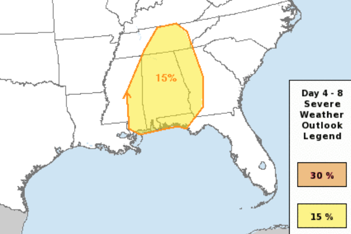
By midweek next week, we are back to the potential for severe weather. On Wednesday it will be the Mid-South and then the Southeast on Thursday. This also means that the potential is looking like an overnight threat Wednesday-into-Thursday of next week for the Southern MS/AL/LA region.

To keep tabs on the chance for a fe flakes, and to monitor the risk for severe weather next week, keep in mind you can always download the NickelBlock Forecasting app!

Once we get through the storms next week we should clear out through the weekend next weekend.
REGIONAL DAY TO DAY FORECAST
Today
Mostly cloudy with a 20 percent chance of showers. Highs in the lower 60s. Northeast winds 5 to 10 mph.
Tonight
Mostly cloudy with a few showers possible. Lows in the lower 40s. North winds 5 to 10 mph. Chance of rain 30 percent.
Saturday
Passing clouds with showers possible. Highs in the lower 50s. North winds 10 to 15 mph. Chance of rain 60 percent.
Saturday Night
Mostly cloudy with a slight chance of showers in the evening, then partly cloudy after midnight. Lows in the upper 30s. Northwest winds 15 to 20 mph. Chance of rain 20 percent.
Sunday
Sunny. Highs in the upper 50s. Northwest winds 10 to 15 mph.
Sunday Night
Mostly clear. Lows in the mid 30s.
Monday
Sunny. Highs in the upper 60s.
Monday Night
Mostly cloudy. Lows in the lower 40s.
Tuesday
Mostly cloudy. A chance of showers with a slight chance of thunderstorms in the afternoon. Highs around 70. Chance of rain 30 percent.
Tuesday Night
Cloudy with a chance of showers with a slight chance of thunderstorms. Not as cool with lows in the lower 60s. Chance of rain 40 percent.
Wednesday
Cloudy with a slight chance of thunderstorms. A slight chance of showers in the morning, then a chance of showers in the afternoon. Highs in the mid 70s. Chance of rain 30 percent.
Wednesday Night
Cloudy with a chance of showers with a slight chance of thunderstorms. Lows in the mid 60s. Chance of rain 50 percent.
Thursday
Mostly cloudy with a slight chance of thunderstorms. Showers likely, mainly in the morning. Highs in the lower 70s. Temperature falling into the upper 60s in the afternoon. Chance of rain 60 percent.


