To my up and coming followers, I’m back with another article review! This one is of a larger interest to me considering it’s tornado related and I just go bonkers for some funnel cloud! This study was done by a team at the NOAA/NWS/NCEP/Storm Prediction Center, in Norman Oklahoma in 2017 and I have to say that it is really wonderful! I truly enjoyed their research the practicality within what they were studying.
Overview:
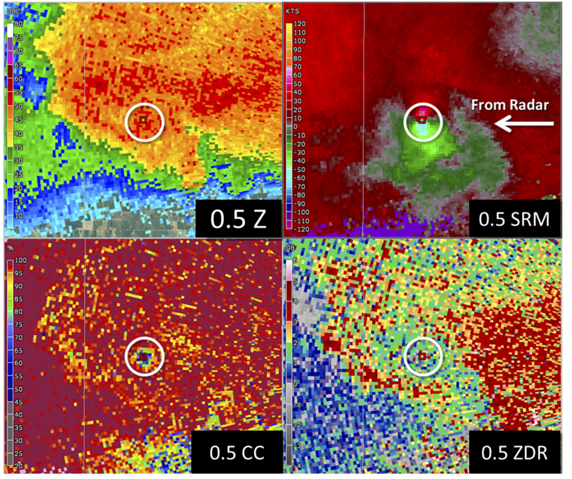
This group designed a research study to look at “tornadic vortex signature (TVS)” and the detection methods in terms of velocity and size on a EF scale. The way in which they ensured a balanced and accurate study included nontornadic circulations with those producing tornadoes and also using a “considerable” or “catastrophic” tag to give a more general classification for threat levels. As I read through their data and methods section, I was rather in awe of how thorough they were in ensuring they selected the most fitting of tornadic cases.
They selected storms from within 2014-2015 and filtered for “the maximum hail, wind, and tornado report magnitude per 40-km horizontal grid box per hour, matching the update frequency and horizontal grid spacing of the SPC hourly mesoanalysis fields”(1512). From there, additional parameters were set on the chosen variables and values to ensure that numbers were calculated in equal and fair conditions and prevent larger systems from dominating the calculations. Through their result portion, they outline the various aspects that they looked to for data study, these include: convective mode, height ARL vs Vrot, combined circulation diameter and height ARL vs Vrot, tornado debris signatures vs Vrot, obvious vs nebulous circulations, and prevalence of damage indicators. Through their findings the conclusion of, “the results presented herein confirm that a low-altitude mesocyclone is more likely to be associated with a tornado than a midlatitude mesocyclone sampled at a greater elevation/distance and, more generally, that the percentage of tornadic mesocyclones is indeed lower than previously thought.
There are several graphs throughout that illustrate the maximum rotational velocity and the coinciding probability of a EF-2 or stronger tornado and the many trials that were pulled from samples to determine the impact certain variables (location, tornado debris, radar reflectivity quality) have on the calculations. The team also concluded that, “despite the clear links between Vrot and tornado damage ratings, the relative lack of damage indicators can result in overestimates of tornado damage rating probabilities. A combination of the factors, including storm environment information like STP, should allow for both accurate and consistent probabilistic guidance for real-time tornado damage estimation and IBW applications.
Modern Meteorology:
This research furthers study today by giving further evidence to support that there are very pivotal variables that impact the reality of calculations more so than previously thought. This team successfully gives new data into the necessary filtration and selection process in order to study tornadic activity on an equal scale, not only looking at the damage done on the ground, but also how that damage can be expected due to the correlating storm measurements. All in all I believe that this has given modern meteorologists a new look at how the EF scale is only one way to view a tornado rating system and how there’s more data to be studied once we branch out of the numbers we gather from the ground impact and rather how we can create a comparison scale that uses the data we collect from the size, rotation, and strength of a tornado.
Further Exploration:
I wish the following topics would’ve been given more depth:
- The tags of “considerable” and “catastrophic” – how did you decide to limit it to two categories? What is the criteria for those as opposed to the EF scale.
- “fuzzy” velocity signatures – why are there no “rigid thresholds” when studying velocity and why did you choose to only study data with large reflecivity? Could the smaller data potentially change the research?
- ARL groupings and beam broadening – I would have liked further clarification regarding why the beam broadening and increasing radar range would have impacted the study significantly enough for mention in the article?
Thanks for reading ya’ll! See ya next week!


