Looking across the country, conditions are largely unchanged from the past few days.
One of the main stories, the heat wave in the Pacific NW, is finally abating, with Excessive Heat Warnings in Central Washington expiring tonight (hopefully for good!)

Looking at today’s high temperature forecasts, the heat is still definitely there-with 100F temperatures in the Snake and Columbia River Valleys of Eastern Washington.
Across most of the Pacific NW, slightly cooler temperatures set the signal that the heat is going to die off, as lower heights at 500 mb start to take hold of the area.

The blue offshore in the Pacific indicates troughing that is likely to start moving into the area later on in the week, while the heat slides further East into the Northern Rockies.
Troughing is also evident on the East Coast, as cooler weather sets up on that side of the country.
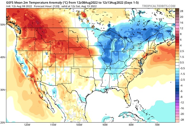
Looking at the actual temperature anomalies, the upper-level pattern supports what we see on the ground. Noticeably cooler weather across the Great Lakes, with average temperatures over the next 5 days running around 8-10F below average, a nice cooldown from the heat all summer long.
Though this pattern is very amplified, with strong ridging in the West, and troughing in the East, there isn’t much in the way of significant weather across the country. Severe Weather doesn’t look to be a problem, as the SPC hasn’t added any significant risk areas.

The CPC has only a few problem areas highlighted, heavy rainfall in the Desert SW, as the monsoon continues, and a flash drought risk across the Midwest and Northern Plains.
Flash drought is a phenomenon that I talked about earlier in the year, but it’s when an area sees intense heat, combined with short term rainfall deficits. It may not hit the official long-term definition of a drought, but short bursts of dry weather and high heat can be detrimental to agriculture, so it is important to keep track of.
Flash flooding is somewhat of a threat, not just in the Desert SW, but also in the SE.
As the battlezone between high and low pressure sets up across much of the South, the area will be very conducive for strong storms and heavy rainfall, especially with the moisture that the warmer-than-usual Gulf of Mexico is putting off. Extreme flooding isn’t likely, but anywhere with previously saturated soils definitely could see some issues.


