Good morning! After a cool and rainy day, it’s looking like we’re going to see more of the same over the next few days. The pattern is probably going to be pretty similar, with rain and storms forming in the late morning/early afternoon.
Yesterday, at Pascagoula, the temperature hit 90F early in the morning, before quickly cooling off due to thunderstorms in the area.
That means that the “high” temperature that I write about may not be the temperature at 3pm, which is typical for this area. Just keep that in mind, that if the rain is widespread enough, we may not even hit those high temperatures.
Looking at the synoptic pattern across the country, we can see a large upper-level low pressure centered over the Northern Gulf.

This trough is responsible for the rain and storms forming around the area, and causing inclement weather across most of the Gulf. As Nick said yesterday, this feature is not likely to develop into any kind of tropical system, though it is technically possible.
The main threats with this system are going to be heavy rain, and occasionally gusty winds. These conditions are going to lead to worse beach weather, with slightly higher surf and a higher rip current risk during the week. NWS Mobile has a beach forecast out to Friday that shows less than ideal conditions at the beach.
During patterns like this, the sea breeze interaction that keeps storms inland doesn’t have as much influence, so coastal areas may not be spared like they sometimes are.
In addition, though storms are more likely in the afternoon, they could form in the mornings as well.

Not that there was ever a question, but the tropical moisture is very rich and deep, and extends over a large part of our area this morning. Higher levels of moisture will give us a risk for heavy rainfall and flash flooding, as has been fairly typical during these patterns this summer.

Looking ahead to Thursday, the conditions are expected to continue. A major pattern change is forecast, as the Southeast US-Bermuda ridge is forecast to fall apart, and letting a longwave trough into the area. We haven’t seen a longwave trough in the Eastern US this summer, though it isn’t centered over our area so we won’t see the cooler temperatures that you see under the center.
What will influence us, is since the “edge” of the ridge, which is in between the high and low pressure areas, is over us, we have a better shot of seeing storm systems riding over the ridge.

The flash flooding risk does exist during the week, with the WPC issuing a slight risk for flash flooding during the day on Wednesday. The best chances for flash flooding are in our SE Louisiana parishes, including New Orleans and Baton Rouge.
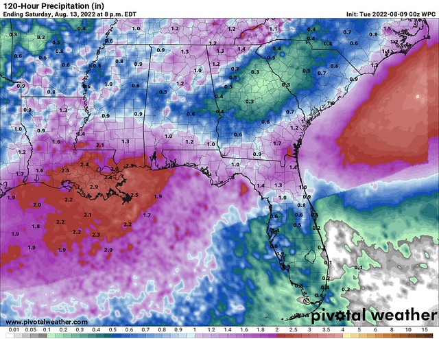
With us being located closer to the coast, we are more likely to see higher rainfall totals closer to 2” in the Coastal Counties/Parishes. The forecast has ticked up in recent days, and it looks like we’re looking at more rain than we previously thought. It would not surprise me to see portions of Southern MS get extended into the flash flooding risk area.

With the pattern continuing, we’re going to get back under Northerly flow, bringing in some drier air into the region later in the week.
We may not feel any drier here at the surface, but the upper-levels are supposed to dry out, which should mean less cloud cover and less extensive rainfall at the end of this week into the weekend.
That’s the good news, this weekend should be a lot better! There will still be scattered thunderstorms, but the weather should improve markedly by the end of the week.

We haven’t seen blue on the long range temperature forecast in a long time, so this is quite the surprise! This won’t mean “cool” weather, but maybe it won’t be quite as hot going into next week.
Day-to-Day Forecast
Today
Mostly cloudy, with a 70-percent chance of rain and thunderstorms, especially in the afternoon. Highs around 90F. Moderate (2/3) rip current risk for the AL/MS beaches.
Tomorrow
Mostly cloudy, with an 80-percent chance of rain and thunderstorms, especially in the afternoon. Highs in the upper-80s. Moderate (2/3) rip current risk for AL/MS beaches. Flash flooding is possible.
Thursday
Mostly cloudy, with a 70-percent chance of rain and thunderstorms, especially in the afternoon. Highs in the upper-80s. High (3/3) rip current risk for AL/MS beaches.
Friday
Partly cloudy, with a 60-percent chance of afternoon thunderstorms. Highs in the upper-80s. High (3/3) rip current risk for AL/MS beaches.
Saturday
Partly cloudy, with a 50-percent chance of afternoon thunderstorms. Highs around 90F.
Sunday
Partly cloudy, with a 30-percent chance of afternoon thunderstorms. Highs in the low-90s.
Monday
Partly cloudy, with a 40-percent chance of afternoon thunderstorms. Highs around 90F.


