Hello folks and TGIF!
Over the next three days, not much will change weather-wise across the Southeast. As the region is still under the influence of what seems like a permanent sub-tropical ridge, most of the region will experience some above average temperatures for the next three days. In addition to this, a slow moving boundary will meander about, bringing the chance for some showers and thunderstorms to portions of Oklahoma, Arkansas, Tennessee and the northern halves of Mississippi, Alabama and Georgia for the next few days. Apart from the chance for storms in these locations, along the coast the threat for some showers and thunderstorms will also exist as isolated storms may fire up along the sea breeze boundaries.
Current Synoptic Picture
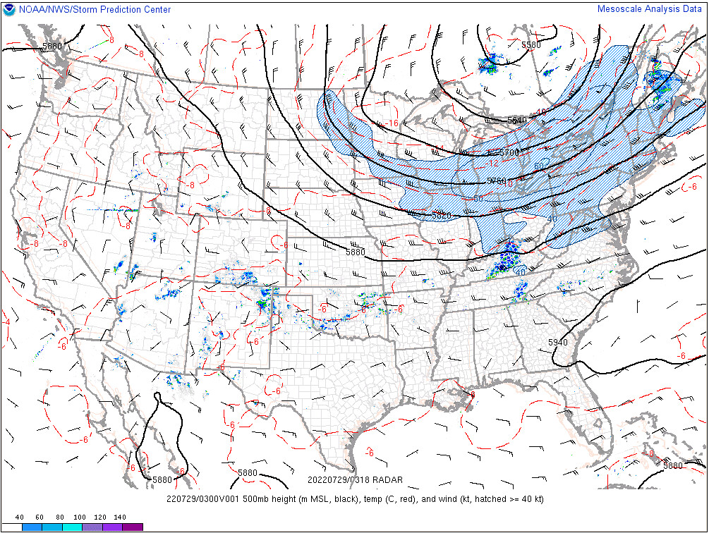
Right now across the CONUS, a large ridge exists over the West Coast, bringing a potent heat wave to the Pacific Northwest. North of the Great Lakes Region, along the Ontario-Quebec border, is an upper-level low, with troughing for the northern half of the country east of the Rockies. Across the southeast, a weak subtropical ridge is in place, extending from the South Carolina and Georgia coast all the way to west Texas.
As a result of the subtropical ridge over the Southeast, the temperatures have been very warm recently – particularly away from the marine-layer air near the coasts. This heat is expected to continue as the ridge fluctuates in intensity through the next few days. Within the influence of this upper-level high pressure, one will expect the typical afternoon pop-up shower or thunderstorm, especially near the coast due to sea breeze boundary interactions.
Today’s Weather
As the upper-level ridge weakens slightly, a large boundary with just enough energy to produce some afternoon showers and thunderstorms will slowly sag southward across the region, brining the chance for showers along the Red River on the Oklahoma-Texas border, southern Arkansas, southern Tennessee and the northern halves of Mississippi, Alabama and Georgia. The chance also exists for some showers and thunderstorms to form ahead of this cold front, on the cold pool and outflow boundaries of the storms that fired earlier in the day – but, generally speaking, the threat for an afternoon storm will decrease the farther south from the front.
Apart from the showers and thunderstorms along this frontal boundary, locations near the Coast will see the threat for showers and thunderstorms as well, as developing sea breeze boundaries will act as an impetus for convection throughout the day.

For the most part, the temperatures are expected to be around what they were yesterday, if not a little cooler due to increased cloudiness from more convection ongoing across the Southeast.

This would entail highs approaching (and in some cases exceeding) 100F for parts of eastern Texas, the upper 90s for northern Louisiana and parts of southern Arkansas – as well as parts of Georgia, South Carolina and Virginia, and in the mid-90s elsewhere across the Southeast. Across some parts of Tennessee and northern Arkansas, however, the temperatures will be notably cooler, due to the presence of cloudiness and showers and thunderstorms from the slow moving cold front.
However, when factoring in the dewpoint at the surface, which remains in the 70s for most locations, the feels-like temperatures will soar well above 100F, with some locations approaching 110F, particularly in eastern Texas, northern Louisiana and parts of northwestern Mississippi.


Tomorrow’s Weather
Much of the same is expected for Saturday, with the sub-tropical ridge weakening slightly again, allowing the slow-moving boundary to inch southward a tad, bringing an increased chance for showers and thunderstorms to much the same regions that will see a threat today. Once again, the same is also true with an increased chance for rain to the south of the boundary, where thunderstorms can fire up along the outflow boundaries of existing convection. Lastly, the coastal regions will still see an increased risk for storms from convection along sea breeze boundaries.

As the same airmass is still in place, temperatures will also remain similar, with once again some slightly cooler temperatures expected near the boundary due to some increased cloudiness and the potential for afternoon showers and thunderstorms, with similar apparent temperatures expected, as well.


Sunday’s Weather
Once again, much the same can be said for Sunday, with the only change being that the sub-tropical ridge will once again begin to strengthen, now pushing the almost stationary front northward a tad, moving the greatest threat for some showers and thunderstorms back to where they were expected Friday, if not a touch more northward. A similar situation exists where isolated showers and thunderstorms can be seen south of the front, firing up along the outflow boundaries of earlier convection.
As far as temperatures go, the story is the same, too, with some slightly warmer temperatures likely as clouds from convection will remain farther North.

This still means, however, that places in northern Mississippi, Alabama and Georgia, as well as most of Tennessee and Arkansas will see some relatively cooler temperatures as the slowly-moving front hangs around.
3-Day Southeast City Forecast
| Dallas, TX | ||
| Friday | Saturday | Sunday |
| High: 100F | High: 99F | High: 100F |
| Low: 81F | Low: 80F | Low: 80F |
| Precip.: 30% | Precip.: 30% | Precip.: 10% |
| Houston, TX | ||
| Friday | Saturday | Sunday |
| High: 93F | High: 93F | High: 94F |
| Low: 80F | Low: 80F | Low: 79F |
| Precip.: 50% | Precip.: 50% | Precip.: 30% |
| New Orleans, LA | ||
| Friday | Saturday | Sunday |
| High: 88F | High: 90F | High: 90F |
| Low: 80F | Low: 80F | Low: 81F |
| Precip.: 70% | Precip.: 50% | Precip.: 30% |
| Little Rock, AR | ||
| Friday | Saturday | Sunday |
| High: 87F | High: 85F | High: 86F |
| Low: 77F | Low: 76F | Low: 76F |
| Precip.: 70% | Precip.: 80% | Precip.: 70% |
| Memphis, TN | ||
| Friday | Saturday | Sunday |
| High: 85F | High: 83F | High: 83F |
| Low: 76F | Low: 74F | Low: 74F |
| Precip.: 80% | Precip.: 70% | Precip.: 80% |
| Birmingham, AL | ||
| Friday | Saturday | Sunday |
| High: 91F | High: 87F | High: 87F |
| Low: 79F | Low: 77F | Low: 76F |
| Precip.: 50% | Precip.: 80% | Precip.: 70% |
| Atlanta, GA | ||
| Friday | Saturday | Sunday |
| High: 93F | High: 87F | High: 87F |
| Low: 77F | Low: 77F | Low: 75F |
| Precip.: 20% | Precip.: 30% | Precip.: 50% |


