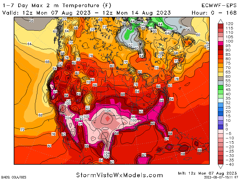
A return to more seasonal conditions over the long-term is in the cards for us here in central and eastern Kansas. High pressure that was responsible for the string of upper 90s to low 100s temperatures has relented and migrated off to the south, opening the door for more mid-level disturbances to swing through and bring relief in the forms of lower temperatures and increased rainfall. This overall pattern will at least hang around in the short-term before the possibility of high pressure slowly inching its way back northward and raising the temperature up a bit, but perhaps not completely shutting out rainfall chances. Overall, this is a more welcome sight than where we were this time last week.
Short-Term Outlook
For today, scattered showers and thunderstorms originating from western Kansas will finish up exiting southern Kansas through the early to mid-morning hours. Once these showers and storms move through, fairly calm and dry conditions will be in place for the rest of the day today, with temperatures largely in the upper 80s to low 90s. Some isolated chance for thunderstorms may exist in north-central Kansas by the early overnight hours (9pm-12am) in the wake of decreasing pressure aloft and modest moisture. Any greater potential for precipitation will occur past midnight and into the morning tomorrow.
For tomorrow, a widespread complex of thunderstorms associated with a traversing shortwave trough will move east-southeast across the state through the early morning hours, beginning at around 1am in north-central Kansas. Some of these storms may be severe by around sunrise, especially along and south of I-35. Moderate wind shear will help support at least a large hail event or two, but the primary hazard will be damaging winds aided by a strengthening low-level jet (in excess of 50 kts) with the southernmost storms. Further severe activity is possible further north, but this is less likely at this time. These storms should fully exit the area out through eastern Kansas by 4pm. This rain-cooled air should also help temperatures stay in the upper 70s to mid 80s.
After storms clear out of the region Wednesday night, warm and dry conditions will settle in for the rest of the state on Thursday, with high temperatures widespread in the mid 80s throughout the day. It will be beyond Thursday before we are looking at another possibility for rainfall for at least some in central to eastern Kansas.
Long-Term Outlook
High pressure will somewhat build back in over Kansas during the end of the week and into next week. Temperatures will largely be consistent through this timeframe, ranging between the mid 80s to mid 90s all the way to next week, as well as at least some chance for isolated showers and thunderstorms with any mesoscale disturbances coming in from the north. This overall pattern looks to last through next week at this time.
Agriculture Forecast
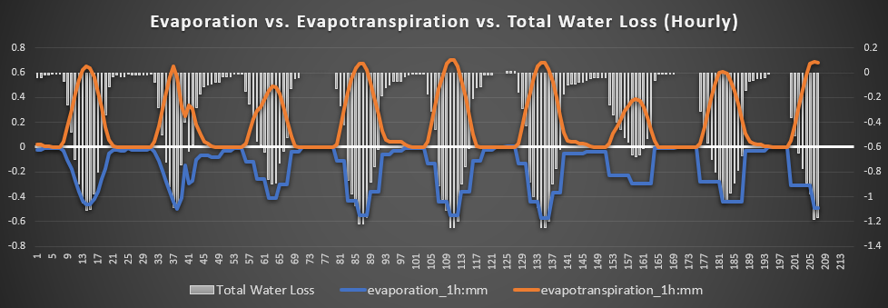
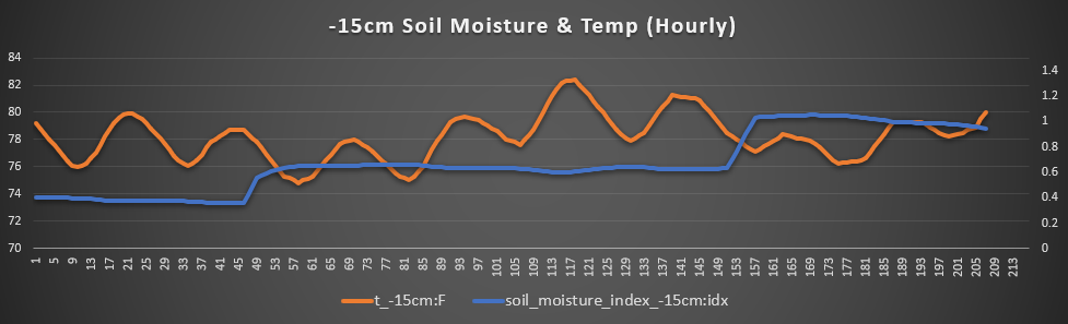
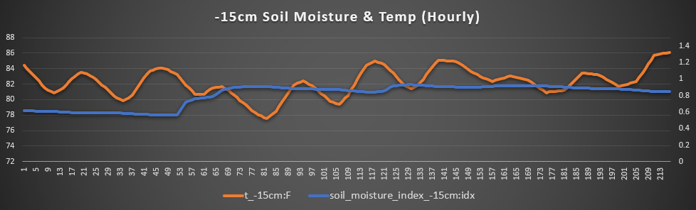
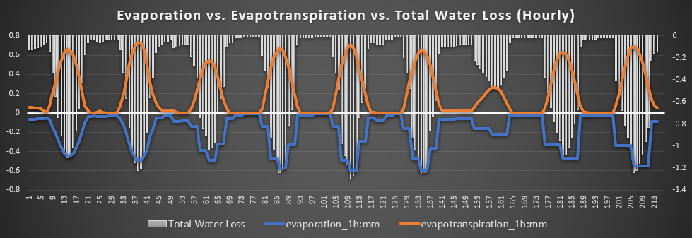
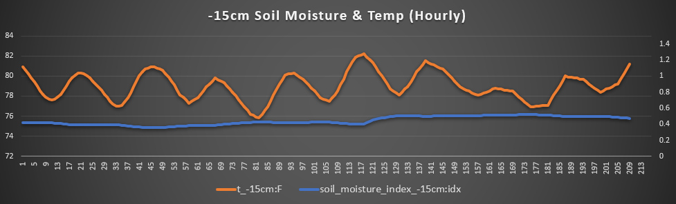
Minneapolis, Beloit, and Concordia – Up here in north-central Kansas will be one of the first to see rainfall from the line of showers and thunderstorms slated to move through the area tonight and into tomorrow morning. Outside of this, temperatures will largely fluctuate between the mid/upper 80s to low 90s throughout the next 7 days. Sustained winds will remain largely out of the north and east at around 5 to 10 mph, also some wind gusts of up to 25 to 30 mph may also be possible. Total water loss rates look to be no greater than 1.2 mm/hr on any given day. Soil temperatures over the next 7 days will also fluctuate between 78° to 82° over the next week, with soil moisture also incrementally increasing through the week.
Pittsburg, Parsons, and St. Paul – The risk for severe weather on Wednesday will be greater down here in southeast Kansas than versus up north. Outside of this, temperatures will remain between the upper 80s to low/mid 90s through the forecast period and winds will remain largely at 5 to 10 mph out of the north and west. Some gusts of up to 20 mph may also be possible. Soil temperatures look to be slightly higher, fluctuating between 82° to 85° and moisture content also looks to increase over the next 7 days. Total water loss rates during this period look to average around 1.1 mm/hr.
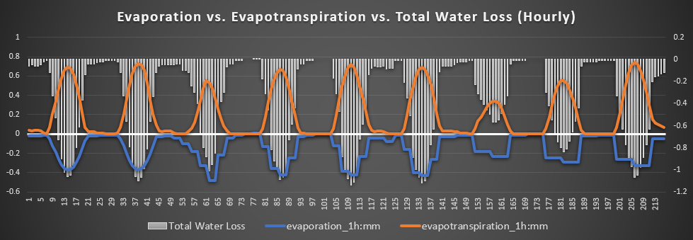
Burlington, Lebo, and Waverly – Like down south, this area may also see a severe thunderstorm or two when the main brunt of these storms roll through Wednesday morning. Looking ahead over the next week, temperatures will bounce between the mid 80s to low 90s and winds will be mainly out of the north and west at 5 to 10 mph. Gustier conditions may be more frequent however, with daily wind gusts of 20 to 25 mph possible. Soil temperatures look to mostly fluctuate between 80° and 83°, with also a steady rise in the moisture content as well. Total water loss rates over the forecast period will more or less hover around the 1.2 mm/hr mark.
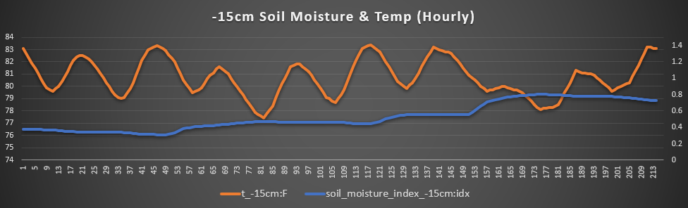
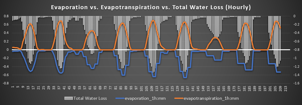
Osage City, Burlingame, and Lyndon – Back here in east-central Kansas, some indications have this area as being the worst off when it comes to soil saturation and water loss (hopefully this is not the case and this area sees improvement from the very dry conditions in place). Average temperatures will remain between the low 80s to low 90s with winds out of the west and north at 5 to 10 mph, although gusts of 15 to 20 will be possible daily. Soil temperatures will hover between 79° and 82° over the next week, although soil moisture appears to be the worst here. Total water loss rates will overall fluctuate between 1.1 to 1.3 mm/hr.
ENSO/Climate Update
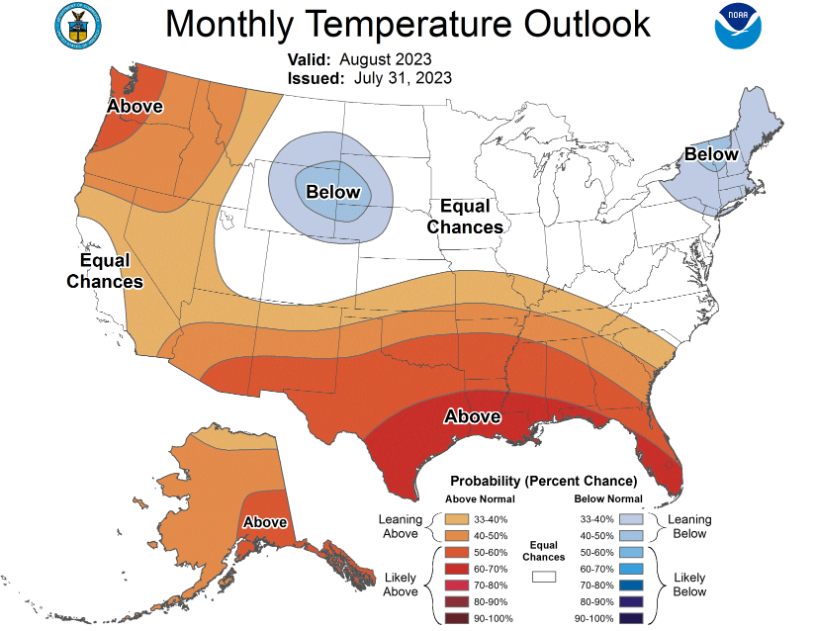
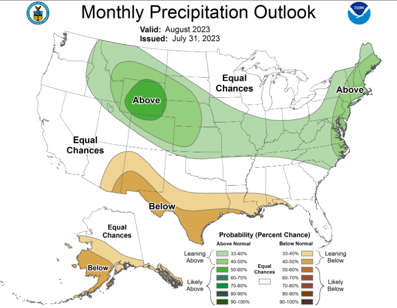
ENSO conditions remain firmly in moderate El Nino conditions, with the potential for strong El Nino conditions likely to set in by the winter. This will continue to generally favor increased rainfall and cooler-than-normal temperatures for the rest of the summer. So far, this is mostly reflected in the monthly climate outlook, with above average rainfall being favored but, contrasting from typical El Nino condition, slightly above average temperatures also being favored.
Drought Update
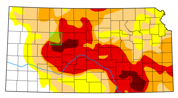
Not much has changed in the drought monitor between last week’s update and this week’s update. Central to southeast Kansas currently still holds the worst reported drought conditions in the state and western Kansas remains largely drought free. Fortunately, more rain chances will generally be favored across virtually the entire state throughout the upcoming week with the current and forecasted upper air pattern. This should help to keep putting dents into the drought throughout the state and slowly but steadily keep drought improvement/removal coming.