The high-res HRRR data came back this afternoon a bit more excited about a low-end severe weather threat for the region on Saturday. This would look quite a bit different than last weekend, but for some folks may actually post a slightly higher risk for severe weather.
Last week, the severe risk looked like this:
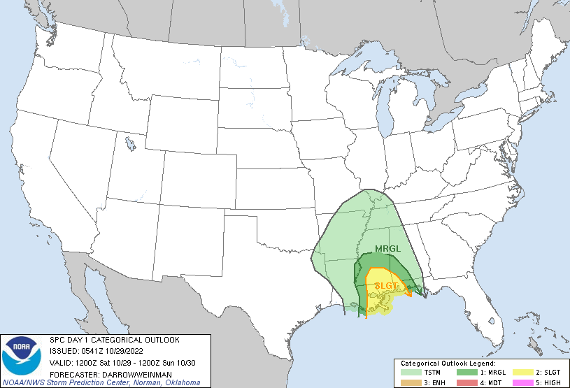
Again, above is last week’s risk. This week, I would argue that the severe risk looks a bit different. The current SPC risk map shows no risk for severe weather, but I have a feeling that may change. And the risk will be higher this week for some relative to last week, and lower for others relative to last week.
THIS WEEK’S RELATIVE RISK
Keeping in mind that this week’s setup is much different than last week’s setup, here is a look at how I think the severe risk has changed relative to last week:

And honestly here, “much higher” is a relative term. Last week the area was under a “Marginal Risk” where the “ceiling” for how severe things could be in that area was “60mph wind gusts” while this week I think there is a potential for a tornado or two in that area.
In the “slightly higher” area , last week it was also a Marginal Risk for mainly wind. I think one or two brief tornadoes will be possible this week.
In the area that is “a little lower” I think it may actually blend pretty close with the “a lot lower” areas nearer to Mobile Bay considering how things turned out. But for places in Mississippi nd other parts of Alabama, the risk this Saturday will also be a little lower based on the available data. Elsewhere, closer to Mobile, the much lower areas will suffice.
And again, I want to stress, the map above is relative to the risk last week. It isn’t an absolute risk map. We will have to wait and see what the SPC goes with for Saturday overnight tonight.
THE DATA
The data suggest that as storms move through the region there will be a window from about 3a through 7a where severe weather may be more likely.
Looking at the estimated radar imagery from the HRRR model, the daisy chain of storms from Houma through, just west of, McComb around 4a are the storms that intrigue me the most. At this time, if storms remain discrete and can get rooted, there will be sufficient parameters met to create the potential for severe weather – wind, hail and brief tornadoes.


By 6a those storms push into southeastern Louisiana and southern Mississippi. And may still have enough ‘umph’ and spin to offer the chance for some severe weather.
By the time we get past sunrise, though, things should start to calm down along the line of storms as they press into Alabama.
And the Skew-Ts support this potential for each spot. Here is a look at the skew-t for along that line as it develops at 3a:

That forecast sounding checks a lot of severe weather boxes. We have instability, shear, helicity, veer-back-veer hodograph, a tall EIL, moderate DCAPE and plenty of omega and vertical motion.
And at each step in the above radar estimates, the Skew-Ts show a favorable environment for severe weather. Not a “good chance” for significant severe weather, but there is certainly a chance for heavy rain, lightning, wind gusts up to 65mph, small hail and a few brief tornadoes.


But as we move through the morning and the line shifts to the east, notice how the Skew-Ts become less, and less favorable.
That is why I think there is a higher risk west relative to last week and a lower risk east relative to last week.
THE BOTTOM LINE
At this time, this does not appear to be a significant severe weather event. In fact, it looks pretty low-end. But I think the risk for severe storms is higher this week for some spots than it was last week. I also think the ceiling for storms in those areas is also higher. Where last week the potential for a tornado was nearly zero, this week it looks a bit higher.
What can you do now? Keep tabs on the forecast. That is about it. And just make sure you’ve got your NOAA Weather Radio handy and an app on your phone that can ping you when a Watch or Warning is issued for your area.
And speaking of apps! I’m coming along with my app still. I missed my self-imposed goal of Halloween, but we are still chugging along and I hope to have it out soon. Stay tuned for updates on that, too!


