You can find the timeline for your county here.
The line of storms for tomorrow looks like a pretty mixed bag with varying possibilities. There is a slim window between where the storms can form and what they can produce.

First of all, looking at the surface analysis for tomorrow, we see the occlusion of the two fronts very far south towards southern Louisiana. This front will move mostly east and slightly north later on, but its dynamic over Louisiana and Mississippi is what we should be concerned about. When I talked about the spike in dewpoints yesterday, this front is the main reason why. Now, the main problem we run into and the different types of severe weather are up to what the blob of rain will block or not. The HRRR model shows a more prominent blob of rain from the Gulf while the NAM Conus reduces it and the line develops a bit more.


All this to say that tornadoes, hail, flooding, lightning, and winds are all possible. The SPC has already stated that some storms are capable of producing decent sized tornadoes and I tend to agree. A few discrete cells ahead of the line and even some of the main line may have some possible tornadoes to form. Some of the storms may also have some hail possible and lightning will be fairly dense. I really think our biggest concern will be flash flooding. The amount of rain we will receive in several hours will likely flood the roadways, creeks, and streams. Rainfall amounts from 1 to over 6 inches are possible over the period. Like every government agency has said at this point, turn around, don’t drown.
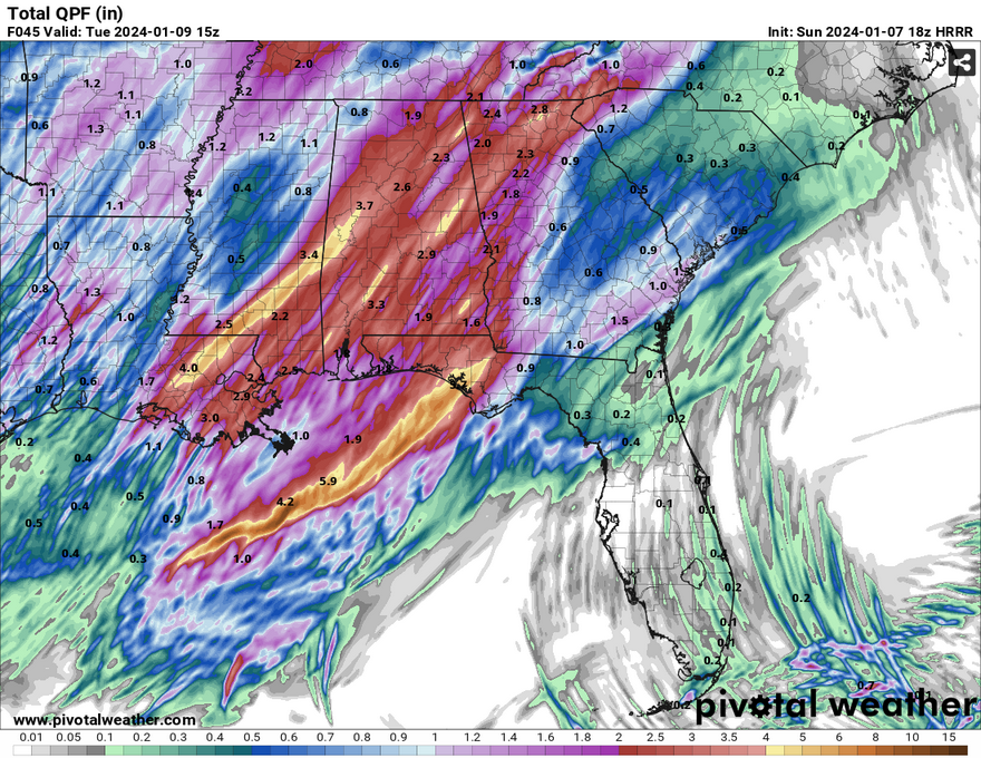
Don’t take the graphic as the complete guide to where the rain will be. Depending on the setup of the squall line, the highest rainfall totals could shift east or west. Either way, many of the streams, creeks, and later on rivers will likely have some flood watches or warnings coming. Please be safe tomorrow, find your safe spot for if/when the warnings may occur, and make a plan just in case.
[wpcode id=”41179″
[wpcode id=”41149″]


