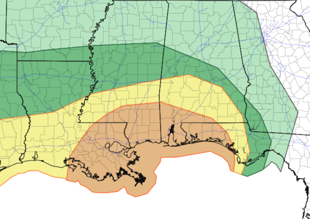
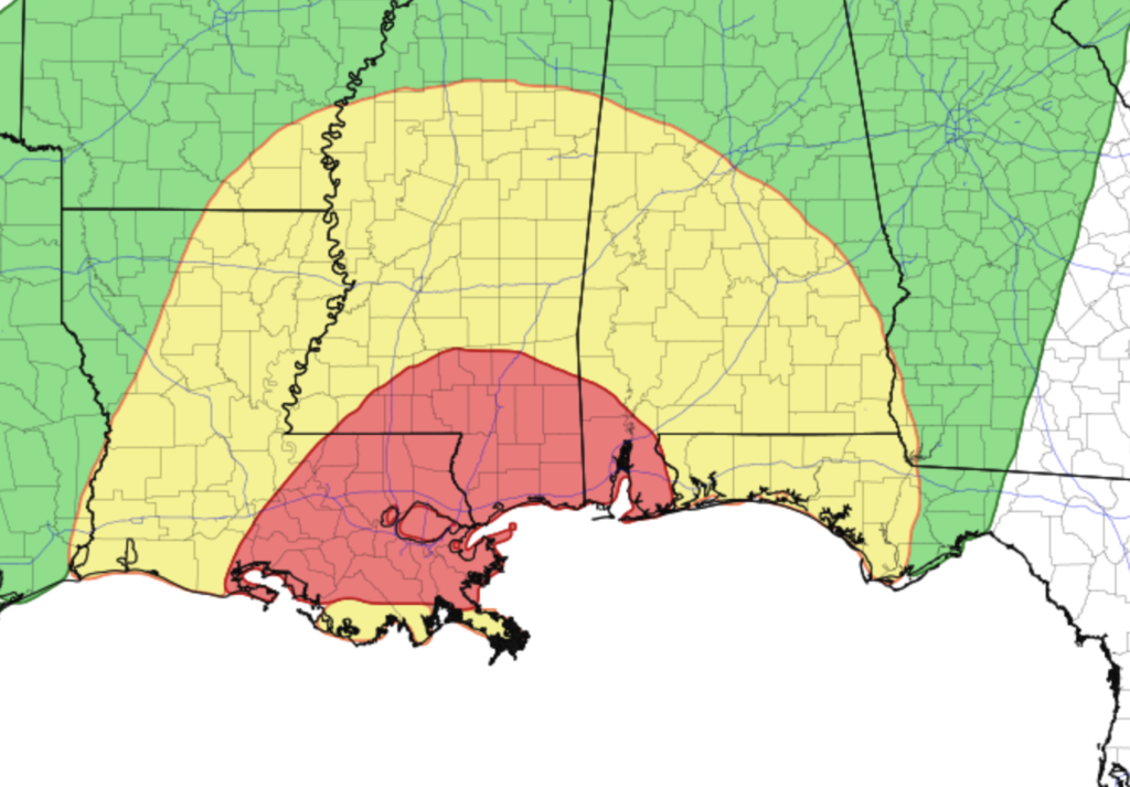
The general forecast is pretty straight-forward. The Storm Prediction Center has a Slight Risk for severe weather north of the Warm Front and an Enhanced Risk for south of the Warm Front for Monday night through Tuesday morning. The Weather Prediction Center shows a Slight Risk across much of the region and a Moderate Risk for flash flooding specifically for southern Mississippi, southeastern Louisiana and near Mobile Bay in Alabama during the window between Monday afternoon and Tuesday morning.
It will be stormy, with the potential for flash flooding.
Generally, the rain starts Monday afternoon, the storms starts Monday evening and overnight into early Tuesday morning, and things ease up by Tuesday in the pre-dawn hours.Some storms overnight could be severe with the potential for a lot of lightning, very heavy rain, wind gusts up to 70mph, hail up to the size of quarters and the potential for a few tornadoes across the region. There will be some sort of flooding for almost everyone (from as little as big puddles to as much as swollen creeks and potential water near homes).
There is a pretty good chance that if you live in our general forecasting area you will be under some type of warning at some point. And there will likely be a Tornado Watch and a Flash Flood Watch issued by the NWS Monday afternoon or evening that lasts until early Tuesday morning.
All the while it will be windy. Not thunderstorm wind. but regular wind. Sustained wind between 25mph and 4mph will be possible with gusts up to 50mph at times. Again, not in the storms, just ‘because’
The specifics of this forecast is about as clear as mud.
It is tough to discern specifically who will get the worst of the flooding potential, there ‘i a chance for a secondary push of warmer air which complicates who is facing the severe weather risk, and there may be a blob of storms off the coast that would throw a wrench in all of this limiting the risk for severe weather and flooding altogether.
So, let’s get down to business….
THE QUICK DETAILS
I mentioned on facebook yesterday that it was a good thing that the air south of Grand Isle shown int eh forecast data wasn’t farther north or we would have a problem.
This morning it was shown a bit farther north.
That’s a problem.
Looking at the weather forecast for Monday and into Tuesday, it looks like the first showers and thunderstorms will start as early as 1pm, especially across some of the western and southwestern counties.
But the real threat for severe weather likely doesn’t arrive until we get into the late evening and overnight hours as a bit of a secondary push of warmer air, as well as some heavier rain, pushes through the area around 7pm and pushes all the way through by 11pm. Once that happens, depending on your location, you will have an increased risk for severe weather.
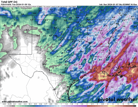
On top of that, those showers and thunderstorms that move through wer will also have the risk for flooding. some area will receive up to 6″ of rain by this point. In particular places where showers train and drop repeated rounds of heavy rain.
Model guidance shows a stripe across parts of the area that could see up to 9″ of rainfall.
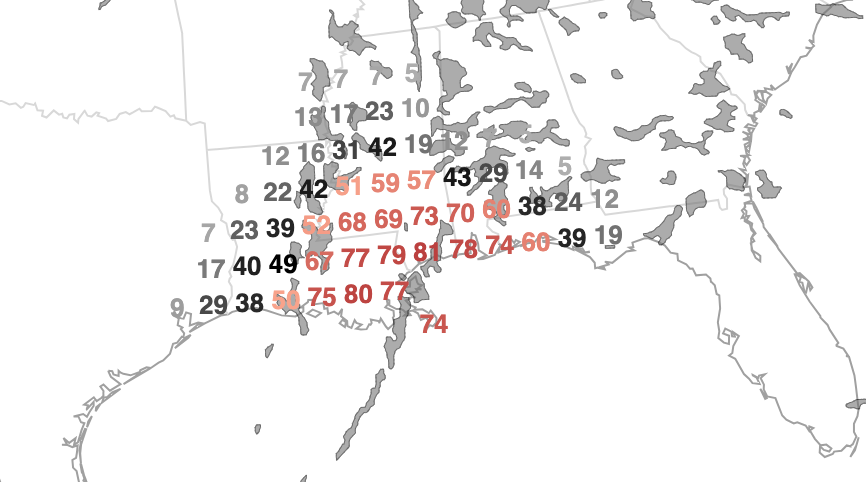
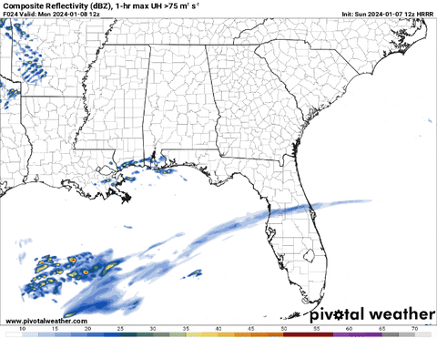
Going back to the severe weather risk, the Updraft Helicity Streaks map below is when we ask the computer to find where it thinks the strongest and most organized storms will be. It does this by using an algorithm to find where, in the data, the data supports rotating updrafts. Also known as spinny storms. And the map below shows a pretty wide spread of spinny storms. But the good news is most of that spinning will be in the mid-levels and not down on the ground.

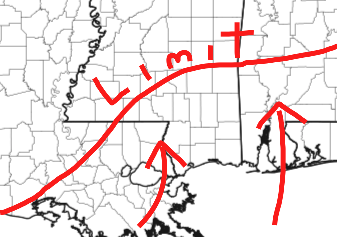
But! Storms that spin in the mid-levels are the first step we need for ID’ing where the strong storms will be and then we can look down on the ground to see if those spinny storms may be surface=-based. And looking back at the map above where I painted on where the limit of warmth for surface-based storms would be we can then look at the map below and say there will likely be a few storms that will be spinning and be surface-based.

Keep in mind with this map that the specific placement of the coloring isn’t as important as how much coloring you see on the map. The computer isn’t great run-to-run at ID’ing where these storms will be, but it is good at picking out if there will be or will not be stronger storms.
So if you see a ton of coloring in an area (lower Alabama, for instance) that is a good indicator to monitor that area – generally – for stronger storms. Same goes with parts of southern and southwestern Mississippi.
Complicating all of this, though, is a blob of storms off the coast and out into the Gulf shown on the model guidance.
That blob would cut off the flow of warm and humid air into the area for most of the afternoon on Monday. It would allow it to sneak in to the west and to the east, but across our area, it would limit how much could seep northward.

But as you can also see in the animation above, it moves east during the evening on Monday and does so juuuuust in time for some warm and humid air to sneak northward before the cold front arrives.
THE BIG QUESTION
All of that discussed above is the reason why the specifics of this forecast are not as straightforward. There is some bit of ‘we don’t know how much’ warm air can move north in the window between the blob and the cold front.
If we get a lot, then the “limit” line I drew up top gets shifted north. If we only get a little that line then is shifted south.
On top of that the potency of the storms is also changed. So, less warm air, the storms aren’t as strong, more warm air, the storms may be stronger.
COUNTY-BY-COUNTY BREAKDOWN
As always, these county-by-county breakdowns for a timeline for potential impacts may change by an hour or two. So please make sure that you are looking at the most recent forecast on this site when referencing these. Feel free to tap/click over to the homepage to see if there has been an update this this was posted.
I-20 CORRIDOR
COPIAH COUNTY
12p — 4p – There may not be much out there, but a few isolated storms may offer brief heavy rain, lightning, gusty wind, small hail. Rainfall totals are estimated to be up to 1 inch.
5p — 9p – There is a chance for showers and storms. Some severe. The main concerns are brief heavy rain, frequent lightning, wind gusts up to 70mph, hail up to the size of quarters, and a brief and weak tornado. Rainfall totals are estimated to be around 1-3 inches.
10p — 2a – There is a chance for showers and storms. Some severe. The main concerns are brief heavy rain, frequent lightning, wind gusts up to 70mph, hail up to the size of quarters, and a brief and weak tornado. Rainfall totals are estimated to be around 1-3 inches.
3a — 7a – Things will be winding down with lingering showers and a few storms. Minimal additional rainfall anticipated.
RANKIN COUNTY
2p — 6p – There may not be much out there, but a few isolated storms may offer brief heavy rain, lightning, gusty wind, small hail. Rainfall totals are estimated to be around 1-3 inches.
7p — 11p – There is a chance for showers and storms. Some severe. The main concerns are brief heavy rain, frequent lightning, wind gusts up to 70mph, hail up to the size of quarters, and a brief and weak tornado. Rainfall totals are estimated to be around 1-3 inches.
12a — 4a – There is a chance for showers and storms. Some severe. The main concerns are brief heavy rain, frequent lightning, wind gusts up to 70mph, hail up to the size of quarters, and a brief and weak tornado. Rainfall totals are estimated to be around 1-3 inches.
5a — 9a – Things will be winding down with lingering showers and a few storms. Minimal additional rainfall anticipated.
SIMPSON COUNTY
1p — 5p – There may not be much out there, but a few isolated storms may offer brief heavy rain, lightning, gusty wind, small hail. Rainfall totals are estimated to be around 1-3 inches.
6p — 10p – There is a chance for showers and storms. Some severe. The main concerns are brief heavy rain, frequent lightning, wind gusts up to 70mph, hail up to the size of quarters, and a brief and weak tornado. Rainfall totals are estimated to be around 1-3 inches.
11p — 3a – There is a chance for showers and storms. Some severe. The main concerns are brief heavy rain, frequent lightning, wind gusts up to 70mph, hail up to the size of quarters, and a brief and weak tornado. Rainfall totals are estimated to be around 1-3 inches.
4a — 8a – Things will be winding down with lingering showers and a few storms. Minimal additional rainfall anticipated.
SCOTT COUNTY
2p — 6p – There may not be much out there, but a few isolated storms may offer brief heavy rain, lightning, gusty wind, small hail. Rainfall totals are estimated to be around 1-3 inches.
7p — 11p – There is a chance for showers and storms. Some severe. The main concerns are brief heavy rain, frequent lightning, wind gusts up to 70mph, hail up to the size of quarters, and a brief and weak tornado. Rainfall totals are estimated to be around 1-3 inches.
12a — 4a – There is a chance for showers and storms. Some severe. The main concerns are brief heavy rain, frequent lightning, wind gusts up to 70mph, hail up to the size of quarters, and a brief and weak tornado. Rainfall totals are estimated to be around 1-3 inches.
5a — 9a – Things will be winding down with lingering showers and a few storms. Minimal additional rainfall anticipated.
SMITH COUNTY
2p — 6p – There may not be much out there, but a few isolated storms may offer brief heavy rain, lightning, gusty wind, small hail. Rainfall totals are estimated to be around 1-3 inches.
7p — 11p – There is a chance for showers and storms. Some severe. The main concerns are brief heavy rain, frequent lightning, wind gusts up to 70mph, hail up to the size of quarters, and a brief and weak tornado. Rainfall totals are estimated to be around 1-3 inches.
12a — 4a – There is a chance for showers and storms. Some severe. The main concerns are brief heavy rain, frequent lightning, wind gusts up to 70mph, hail up to the size of quarters, and a brief and weak tornado. Rainfall totals are estimated to be around 1-3 inches.
5a — 9a – Things will be winding down with lingering showers and a few storms. Minimal additional rainfall anticipated.
NEWTON COUNTY
2p — 6p – There may not be much out there, but a few isolated storms may offer brief heavy rain, lightning, gusty wind, small hail. Rainfall totals are estimated to be up to 1 inch.
7p — 11p – There is a chance for showers and storms. Some severe. The main concerns are brief heavy rain, frequent lightning, wind gusts up to 60mph, hail up to the size of quarters, and a brief and weak tornado. Rainfall totals are estimated to be around 1-3 inches..
12a — 4a – There is a chance for showers and storms. Some severe. The main concerns are brief heavy rain, frequent lightning, wind gusts up to 60mph, hail up to the size of quarters, and a brief and weak tornado. Rainfall totals are estimated to be around 1-3 inches.
5a — 9a – Things will be winding down with lingering showers and a few storms. Minimal additional rainfall anticipated.
JASPER COUNTY
2p — 6p – There may not be much out there, but a few isolated storms may offer brief heavy rain, lightning, gusty wind, small hail. Rainfall totals are estimated to be up to 1 inch.
7p — 11p – There is a chance for showers and storms. Some severe. The main concerns are brief heavy rain, frequent lightning, wind gusts up to 60mph, hail up to the size of quarters, and a brief and weak tornado. Rainfall totals are estimated to be around 1-3 inches..
12a — 4a – There is a chance for showers and storms. Some severe. The main concerns are brief heavy rain, frequent lightning, wind gusts up to 70mph, hail up to the size of quarters, and a brief and weak tornado. Rainfall totals are estimated to be around 2-4 inches..
5a — 9a – Things will be winding down with lingering showers and a few storms. Minimal additional rainfall anticipated.
LAUDERDALE COUNTY
3p — 7p – There may not be much out there, but a few isolated storms may offer brief heavy rain, lightning, gusty wind, small hail. Rainfall totals are estimated to be up to 1 inch.
8p — 12a – There is a chance for showers and storms. Some severe. The main concerns are brief heavy rain, frequent lightning, wind gusts up to 50mph, hail up to the size of quarters, and a brief and weak tornado. Rainfall totals are estimated to be around 1-3 inches..
1a — 5a – There is a chance for showers and storms. Some severe. The main concerns are brief heavy rain, frequent lightning, wind gusts up to 60mph, hail up to the size of quarters, and a brief and weak tornado. Rainfall totals are estimated to be around 1-3 inches..
6a — 10a – Things will be winding down with lingering showers and a few storms. Minimal additional rainfall anticipated.
CLARKE COUNTY
3p — 7p – There may not be much out there, but a few isolated storms may offer brief heavy rain, lightning, gusty wind, small hail. Rainfall totals are estimated to be up to 1 inch.
8p — 12a – There is a chance for showers and storms. Some severe. The main concerns are brief heavy rain, frequent lightning, wind gusts up to 50mph, hail up to the size of quarters, and a brief and weak tornado. Rainfall totals are estimated to be around 1-3 inches..
1a — 5a – There is a chance for showers and storms. Some severe. The main concerns are brief heavy rain, frequent lightning, wind gusts up to 60mph, hail up to the size of quarters, and a brief and weak tornado. Rainfall totals are estimated to be around 1-3 inches..
6a — 10a – Things will be winding down with lingering showers and a few storms. Minimal additional rainfall anticipated.
HIGHWAY 84 CORRIDOR
LINCOLN COUNTY
12p — 4p – There may not be much out there, but a few isolated storms may offer brief heavy rain, lightning, gusty wind, small hail. Rainfall totals are estimated to be up to 1 inch.
5p — 9p – There is a chance for showers and storms. Some severe. The main concerns are brief heavy rain, frequent lightning, wind gusts up to 70mph, hail up to the size of quarters, and a brief and weak tornado. Rainfall totals are estimated to be around 1-3 inches.
10p — 2a – There is a chance for showers and storms. Some severe. The main concerns are brief heavy rain, frequent lightning, wind gusts up to 70mph, hail up to the size of quarters, and a brief and weak tornado. Rainfall totals are estimated to be around 1-3 inches.
3a — 7a – Things will be winding down with lingering showers and a few storms. Minimal additional rainfall anticipated.
LAWRENCE COUNTY
1p — 5p – There may not be much out there, but a few isolated storms may offer brief heavy rain, lightning, gusty wind, small hail. Rainfall totals are estimated to be around 1-3 inches.
6p — 10p – There is a chance for showers and storms. Some severe. The main concerns are brief heavy rain, frequent lightning, wind gusts up to 70mph, hail up to the size of quarters, and a brief and weak tornado. Rainfall totals are estimated to be around 1-3 inches.
11p — 3a – There is a chance for showers and storms. Some severe. The main concerns are brief heavy rain, frequent lightning, wind gusts up to 70mph, hail up to the size of quarters, and a brief and weak tornado. Rainfall totals are estimated to be around 1-3 inches.
4a — 8a – Things will be winding down with lingering showers and a few storms. Minimal additional rainfall anticipated.
JEFF DAVIS COUNTY
1p — 5p – There may not be much out there, but a few isolated storms may offer brief heavy rain, lightning, gusty wind, small hail. Rainfall totals are estimated to be around 1-3 inches.
6p — 10p – There is a chance for showers and storms. Some severe. The main concerns are brief heavy rain, frequent lightning, wind gusts up to 70mph, hail up to the size of quarters, and a brief and weak tornado. Rainfall totals are estimated to be around 1-3 inches.
11p — 3a – There is a chance for showers and storms. Some severe. The main concerns are brief heavy rain, frequent lightning, wind gusts up to 70mph, hail up to the size of quarters, and a brief and weak tornado. Rainfall totals are estimated to be around 1-3 inches.
4a — 8a – Things will be winding down with lingering showers and a few storms. Minimal additional rainfall anticipated.
COVINGTON COUNTY
2p — 6p – There may not be much out there, but a few isolated storms may offer brief heavy rain, lightning, gusty wind, small hail. Rainfall totals are estimated to be up to 1 inch.
7p — 11p – There is a chance for showers and storms. Some severe. The main concerns are brief heavy rain, frequent lightning, wind gusts up to 50mph, hail up to the size of quarters, and a brief and weak tornado. Rainfall totals are estimated to be between 1-3 inches..
12a — 4a – There is a chance for showers and storms. Some severe. The main concerns are brief heavy rain, frequent lightning, wind gusts up to 70mph, hail up to the size of quarters, and a brief and weak tornado.. Rainfall totals are estimated to be around 2-4 inches.
5a — 9a – Things will be winding down with lingering showers and a few storms. Minimal additional rainfall anticipated.
JONES COUNTY
2p — 6p – There may not be much out there, but a few isolated storms may offer brief heavy rain, lightning, gusty wind, small hail. Rainfall totals are estimated to be up to 1 inch.
7p — 11p – There is a chance for showers and storms. Some severe. The main concerns are brief heavy rain, frequent lightning, wind gusts up to 60mph, hail up to the size of quarters, and a brief and weak tornado. Rainfall totals are estimated to be around 1-3 inches..
12a — 4a – There is a chance for showers and storms. Some severe. The main concerns are brief heavy rain, frequent lightning, wind gusts up to 70mph, hail up to the size of quarters, and a tornado up to EF-3 in strength is possible. Rainfall totals are estimated to be around 1-3 inches.
5a — 9a – Things will be winding down with lingering showers and a few storms. Minimal additional rainfall anticipated.
WAYNE COUNTY
3p — 7p – There may not be much out there, but a few isolated storms may offer brief heavy rain, lightning, gusty wind, small hail. Rainfall totals are estimated to be up to 1 inch.
8p — 12a – There is a chance for showers and storms. Some severe. The main concerns are brief heavy rain, frequent lightning, wind gusts up to 50mph, hail up to the size of quarters, and a brief and weak tornado. Rainfall totals are estimated to be around 1-3 inches..
1a — 5a – There is a chance for showers and storms. Some severe. The main concerns are brief heavy rain, frequent lightning, wind gusts up to 70mph, hail up to the size of quarters, and a tornado up to EF-3 in strength is possible. Rainfall totals are estimated to be around 1-3 inches.
6a — 10a – Things will be winding down with lingering showers and a few storms. Minimal additional rainfall anticipated.
HIGHWAY 98 CORRIDOR
PIKE COUNTY
12p — 4p – There may not be much out there, but a few isolated storms may offer brief heavy rain, lightning, gusty wind, small hail. Rainfall totals are estimated to be up to 1 inch.
5p — 9p – There is a chance for showers and storms. Some severe. The main concerns are brief heavy rain, frequent lightning, wind gusts up to 70mph, hail up to the size of quarters, and a brief and weak tornado. Rainfall totals are estimated to be around 1-3 inches.
10p — 2a – There is a chance for showers and storms. Some severe. The main concerns are brief heavy rain, frequent lightning, wind gusts up to 70mph, hail up to the size of quarters, and a brief and weak tornado. Rainfall totals are estimated to be around 1-3 inches.
3a — 7a – Things will be winding down with lingering showers and a few storms. Minimal additional rainfall anticipated.
WALTHALL COUNTY
1p — 5p – There may not be much out there, but a few isolated storms may offer brief heavy rain, lightning, gusty wind, small hail. Rainfall totals are estimated to be up to 1 inch.
6p — 10p – There is a chance for showers and storms. Some severe. The main concerns are brief heavy rain, frequent lightning, wind gusts up to 70mph, hail up to the size of quarters, and a brief and weak tornado. Rainfall totals are estimated to be around 1-3 inches.
11p — 3a – There is a chance for showers and storms. Some severe. The main concerns are brief heavy rain, frequent lightning, wind gusts up to 70mph, hail up to the size of quarters, and a tornado up to EF-3 in strength is possible. Rainfall totals are estimated to be around 2-4 inches.
4a — 8a – Things will be winding down with lingering showers and a few storms. Minimal additional rainfall anticipated.
MARION COUNTY
1p — 5p – There may not be much out there, but a few isolated storms may offer brief heavy rain, lightning, gusty wind, small hail. Rainfall totals are estimated to be up to 1 inch.
6p — 10p – There is a chance for showers and storms. Some severe. The main concerns are brief heavy rain, frequent lightning, wind gusts up to 50mph, hail up to the size of quarters, and a brief and weak tornado. Rainfall totals are estimated to be around 1-3 inches.
11p — 3a – There is a chance for showers and storms. Some severe. The main concerns are brief heavy rain, frequent lightning, wind gusts up to 70mph, hail up to the size of quarters, and a tornado up to EF-3 in strength is possible. Rainfall totals are estimated to be around 2-4 inches.
4a — 8a – Things will be winding down with lingering showers and a few storms. Minimal additional rainfall anticipated.
LAMAR COUNTY
2p — 6p – There may not be much out there, but a few isolated storms may offer brief heavy rain, lightning, gusty wind, small hail. Rainfall totals are estimated to be up to 1 inch.
7p — 11p – There is a chance for showers and storms. Some severe. The main concerns are brief heavy rain, frequent lightning, wind gusts up to 50mph, hail up to the size of quarters, and a brief and weak tornado. Rainfall totals are estimated to up to 1 inch.
12a — 4a – There is a chance for showers and storms. Some severe. The main concerns are brief heavy rain, frequent lightning, wind gusts up to 70mph, hail up to the size of quarters, and a tornado up to EF-3 in strength is possible. Rainfall totals are estimated to be around 1-3 inches.
5a — 9a – Things will be winding down with lingering showers and a few storms. Minimal additional rainfall anticipated.
FORREST COUNTY
2p — 6p – There may not be much out there, but a few isolated storms may offer brief heavy rain, lightning, gusty wind, small hail. Rainfall totals are estimated to be up to 1 inch.
7p — 11p – There is a chance for showers and storms. Some severe. The main concerns are brief heavy rain, frequent lightning, wind gusts up to 50mph, hail up to the size of quarters, and a brief and weak tornado. Rainfall totals are estimated to up to 1 inch.
12a — 4a – There is a chance for showers and storms. Some severe. The main concerns are brief heavy rain, frequent lightning, wind gusts up to 70mph, hail up to the size of quarters, and a tornado up to EF-3 in strength is possible. Rainfall totals are estimated to be around 1-3 inches.
5a — 9a – Things will be winding down with lingering showers and a few storms. Minimal additional rainfall anticipated.
PERRY COUNTY
3p — 7p – There may not be much out there, but a few isolated storms may offer brief heavy rain, lightning, gusty wind, small hail. Rainfall totals are estimated to be up to 1 inch.
8p — 12a – There is a chance for showers and storms. Some severe. The main concerns are brief heavy rain, frequent lightning, wind gusts up to 50mph, hail up to the size of quarters, and a brief and weak tornado. Rainfall totals are estimated to up to 1 inch.
1a — 5a – There is a chance for showers and storms. Some severe. The main concerns are brief heavy rain, frequent lightning, wind gusts up to 70mph, hail up to the size of quarters, and a tornado up to EF-3 in strength is possible. Rainfall totals are estimated to be around 1-3 inches.
6a — 10a – Things will be winding down with lingering showers and a few storms. Minimal additional rainfall anticipated.
GREENE COUNTY
3p — 7p – There may not be much out there, but a few isolated storms may offer brief heavy rain, lightning, gusty wind, small hail. Rainfall totals are estimated to be up to 1 inch.
8p — 12a – There is a chance for showers and storms. Some severe. The main concerns are brief heavy rain, frequent lightning, wind gusts up to 50mph, hail up to the size of quarters, and a brief and weak tornado. Rainfall totals are estimated to be around 1-3 inches.
1a — 5a – There is a chance for showers and storms. Some severe. The main concerns are brief heavy rain, frequent lightning, wind gusts up to 70mph, hail up to the size of quarters, and a tornado up to EF-3 in strength is possible. Rainfall totals are estimated to be around 1-3 inches.
6a — 10a – Things will be winding down with lingering showers and a few storms. Minimal additional rainfall anticipated.
HIGHWAY 26 CORRIDOR
PEARL RIVER COUNTY
1p — 5p – There may not be much out there, but a few isolated storms may offer brief heavy rain, lightning, gusty wind, small hail. Rainfall totals are estimated to be up to 1 inch.
6p — 10p – There is a chance for showers and storms. Some severe. The main concerns are brief heavy rain, frequent lightning, wind gusts up to 50mph, hail up to the size of quarters, and a brief and weak tornado. Rainfall totals are estimated to be around 1-3 inches.
11p — 3a – There is a chance for showers and storms. Some severe. The main concerns are brief heavy rain, frequent lightning, wind gusts up to 70mph, hail up to the size of quarters, and a tornado up to EF-3 in strength is possible. Rainfall totals are estimated to be around 2-4 inches.
4a — 8a – Things will be winding down with lingering showers and a few storms. Minimal additional rainfall anticipated.
STONE COUNTY
2p — 6p – There may not be much out there, but a few isolated storms may offer brief heavy rain, lightning, gusty wind, small hail. Rainfall totals are estimated to be up to 1 inch.
7p — 11p – There is a chance for showers and storms. Some severe. The main concerns are brief heavy rain, frequent lightning, wind gusts up to 50mph, hail up to the size of quarters, and a brief and weak tornado. Rainfall totals are estimated to be around 1-3 inches.
12a — 4a – There is a chance for showers and storms. Some severe. The main concerns are brief heavy rain, frequent lightning, wind gusts up to 70mph, hail up to the size of quarters, and a tornado up to EF-3 in strength is possible. Rainfall totals are estimated to be around 1-3 inches.
5a — 9a – Things will be winding down with lingering showers and a few storms. Minimal additional rainfall anticipated.
GEORGE COUNTY
3p — 7p – There may not be much out there, but a few isolated storms may offer brief heavy rain, lightning, gusty wind, small hail. Rainfall totals are estimated to be up to 1 inch.
8p — 12a – There is a chance for showers and storms. Some severe. The main concerns are brief heavy rain, frequent lightning, wind gusts up to 50mph, hail up to the size of quarters, and a brief and weak tornado. Rainfall totals are estimated to be around 1-3 inches.
1a — 5a – There is a chance for showers and storms. Some severe. The main concerns are brief heavy rain, frequent lightning, wind gusts up to 70mph, hail up to the size of quarters, and a tornado up to EF-3 in strength is possible. Rainfall totals are estimated to be around 1-3 inches.
6a — 10a – Things will be winding down with lingering showers and a few storms. Minimal additional rainfall anticipated.
I-10 CORRIDOR
HANCOCK COUNTY
1p — 5p – There may not be much out there, but a few isolated storms may offer brief heavy rain, lightning, gusty wind, small hail. Rainfall totals are estimated to be up to 1 inch.
6p — 10p – There is a chance for showers and storms. Some severe. The main concerns are brief heavy rain, frequent lightning, wind gusts up to 50mph, hail up to the size of quarters, and a brief and weak tornado. Rainfall totals are estimated to be around 1-3 inches.
11p — 3a – There is a chance for showers and storms. Some severe. The main concerns are brief heavy rain, frequent lightning, wind gusts up to 70mph, hail up to the size of quarters, and a tornado up to EF-3 in strength is possible. Rainfall totals are estimated to be around 2-4 inches.
4a — 8a – Things will be winding down with lingering showers and a few storms. Minimal additional rainfall anticipated.
HARRISON COUNTY
2p — 6p – There may not be much out there, but a few isolated storms may offer brief heavy rain, lightning, gusty wind, small hail. Rainfall totals are estimated to be up to 1 inch.
7p — 11p – There is a chance for showers and storms. Some severe. The main concerns are brief heavy rain, frequent lightning, wind gusts up to 50mph, hail up to the size of quarters, and a brief and weak tornado. Rainfall totals are estimated to be around 1-3 inches.
12a — 4a – There is a chance for showers and storms. Some severe. The main concerns are brief heavy rain, frequent lightning, wind gusts up to 70mph, hail up to the size of quarters, and a tornado up to EF-3 in strength is possible. Rainfall totals are estimated to be around 1-3 inches.
5a — 9a – Things will be winding down with lingering showers and a few storms. Minimal additional rainfall anticipated.
JACKSON COUNTY
3p — 7p – There may not be much out there, but a few isolated storms may offer brief heavy rain, lightning, gusty wind, small hail. Rainfall totals are estimated to be up to 1 inch.
8p — 12a – There is a chance for showers and storms. Some severe. The main concerns are brief heavy rain, frequent lightning, wind gusts up to 50mph, hail up to the size of quarters, and a brief and weak tornado. Rainfall totals are estimated to be around 1-3 inches.
1a — 5a – There is a chance for showers and storms. Some severe. The main concerns are brief heavy rain, frequent lightning, wind gusts up to 70mph, hail up to the size of quarters, and a tornado up to EF-3 in strength is possible. Rainfall totals are estimated to be around 1-3 inches.
6a — 10a – Things will be winding down with lingering showers and a few storms. Minimal additional rainfall anticipated.
LOUISIANA PARISHES
ST. HELENA PARISH
12p — 4p – There may not be much out there, but a few isolated storms may offer brief heavy rain, lightning, gusty wind, small hail. Rainfall totals are estimated to be up to 1 inch.
5p — 9p – There is a chance for showers and storms. Some severe. The main concerns are brief heavy rain, frequent lightning, wind gusts up to 70mph, hail up to the size of quarters, and a brief and weak tornado. Rainfall totals are estimated to be around 2-4 inches.
10p — 2a – There is a chance for showers and storms. Some severe. The main concerns are brief heavy rain, frequent lightning, wind gusts up to 70mph, hail up to the size of quarters, and a brief and weak tornado. Rainfall totals are estimated to be around 2-4 inches.
3a — 7a – Things will be winding down with lingering showers and a few storms. Minimal additional rainfall anticipated.
LIVINGSTON PARISH
12p — 4p – There may not be much out there, but a few isolated storms may offer brief heavy rain, lightning, gusty wind, small hail. Rainfall totals are estimated to be up to 1 inch.
5p — 9p – There is a chance for showers and storms. Some severe. The main concerns are brief heavy rain, frequent lightning, wind gusts up to 70mph, hail up to the size of quarters, and a brief and weak tornado. Rainfall totals are estimated to be around 2-4 inches.
10p — 2a – There is a chance for showers and storms. Some severe. The main concerns are brief heavy rain, frequent lightning, wind gusts up to 70mph, hail up to the size of quarters, and a brief and weak tornado. Rainfall totals are estimated to be around 2-4 inches.
3a — 7a – Things will be winding down with lingering showers and a few storms. Minimal additional rainfall anticipated.
TANGIPAHOA PARISH
1p — 5p – There may not be much out there, but a few isolated storms may offer brief heavy rain, lightning, gusty wind, small hail. Rainfall totals are estimated to be up to 1 inch.
6p — 10p – There is a chance for showers and storms. Some severe. The main concerns are brief heavy rain, frequent lightning, wind gusts up to 70mph, hail up to the size of quarters, and a brief and weak tornado. Rainfall totals are estimated to be around 1-3 inches.
11p — 3a – There is a chance for showers and storms. Some severe. The main concerns are brief heavy rain, frequent lightning, wind gusts up to 70mph, hail up to the size of quarters, and a tornado up to EF-3 in strength is possible. Rainfall totals are estimated to be around 2-4 inches.
4a — 8a – Things will be winding down with lingering showers and a few storms. Minimal additional rainfall anticipated.
ST. TAMMANY PARISH
1p — 5p – There may not be much out there, but a few isolated storms may offer brief heavy rain, lightning, gusty wind, small hail. Rainfall totals are estimated to be up to 1 inch.
6p — 10p – There is a chance for showers and storms. Some severe. The main concerns are brief heavy rain, frequent lightning, wind gusts up to 70mph, hail up to the size of quarters, and a brief and weak tornado. Rainfall totals are estimated to be around 1-3 inches.
11p — 3a – There is a chance for showers and storms. Some severe. The main concerns are brief heavy rain, frequent lightning, wind gusts up to 70mph, hail up to the size of quarters, and a tornado up to EF-3 in strength is possible. Rainfall totals are estimated to be around 2-4 inches.
4a — 8a – Things will be winding down with lingering showers and a few storms. Minimal additional rainfall anticipated.
WASHINGTON PARISH
1p — 5p – There may not be much out there, but a few isolated storms may offer brief heavy rain, lightning, gusty wind, small hail. Rainfall totals are estimated to be up to 1 inch.
6p — 10p – There is a chance for showers and storms. Some severe. The main concerns are brief heavy rain, frequent lightning, wind gusts up to 50mph, hail up to the size of quarters, and a brief and weak tornado. Rainfall totals are estimated to be around 1-3 inches.
11p — 3a – There is a chance for showers and storms. Some severe. The main concerns are brief heavy rain, frequent lightning, wind gusts up to 70mph, hail up to the size of quarters, and a tornado up to EF-3 in strength is possible. Rainfall totals are estimated to be around 1-3 inches.
4a — 8a – Things will be winding down with lingering showers and a few storms. Minimal additional rainfall anticipated.
ALABAMA COUNTIES
SUMTER COUNTY
3p — 7p – There may not be much out there, but a few isolated storms may offer brief heavy rain, lightning, gusty wind, small hail. Rainfall totals are estimated to be up to 1 inch.
8p — 12a – There is a chance for showers and storms. Some severe. The main concerns are brief heavy rain, frequent lightning, wind gusts up to 50mph, hail up to the size of quarters, and a brief and weak tornado. Rainfall totals are estimated to be around 1-3 inches..
1a — 5a – There is a chance for showers and storms. Some severe. The main concerns are brief heavy rain, frequent lightning, wind gusts up to 60mph, hail up to the size of quarters, and a brief and weak tornado. Rainfall totals are estimated to be around 1-3 inches..
6a — 10a – Things will be winding down with lingering showers and a few storms. Minimal additional rainfall anticipated.
CHOCTAW COUNTY
3p — 7p – There may not be much out there, but a few isolated storms may offer brief heavy rain, lightning, gusty wind, small hail. Rainfall totals are estimated to be up to 1 inch.
8p — 12a – There is a chance for showers and storms. Some severe. The main concerns are brief heavy rain, frequent lightning, wind gusts up to 50mph, hail up to the size of quarters, and a brief and weak tornado. Rainfall totals are estimated to be around 1-3 inches..
1a — 5a – There is a chance for showers and storms. Some severe. The main concerns are brief heavy rain, frequent lightning, wind gusts up to 70mph, hail up to the size of quarters, and a tornado up to EF-3 in strength is possible. Rainfall totals are estimated to be around 1-3 inches.
6a — 10a – Things will be winding down with lingering showers and a few storms. Minimal additional rainfall anticipated.
WASHINGTON COUNTY
3p — 7p – There may not be much out there, but a few isolated storms may offer brief heavy rain, lightning, gusty wind, small hail. Rainfall totals are estimated to be up to 1 inch.
8p — 12a – There is a chance for showers and storms. Some severe. The main concerns are brief heavy rain, frequent lightning, wind gusts up to 50mph, hail up to the size of quarters, and a brief and weak tornado. Rainfall totals are estimated to be around 1-3 inches.
1a — 5a – There is a chance for showers and storms. Some severe. The main concerns are brief heavy rain, frequent lightning, wind gusts up to 70mph, hail up to the size of quarters, and a tornado up to EF-3 in strength is possible. Rainfall totals are estimated to be around 1-3 inches.
6a — 10a – Things will be winding down with lingering showers and a few storms. Minimal additional rainfall anticipated.
MOBILE COUNTY
3p — 7p – There may not be much out there, but a few isolated storms may offer brief heavy rain, lightning, gusty wind, small hail. Rainfall totals are estimated to be up to 1 inch.
8p — 12a – There is a chance for showers and storms. Some severe. The main concerns are brief heavy rain, frequent lightning, wind gusts up to 50mph, hail up to the size of quarters, and a brief and weak tornado. Rainfall totals are estimated to be around 1-3 inches.
1a — 5a – There is a chance for showers and storms. Some severe. The main concerns are brief heavy rain, frequent lightning, wind gusts up to 70mph, hail up to the size of quarters, and a tornado up to EF-3 in strength is possible. Rainfall totals are estimated to be around 1-3 inches.
6a — 10a – Things will be winding down with lingering showers and a few storms. Minimal additional rainfall anticipated.
THE BOTTOM LINE
It is going to be a stormy afternoon, evening and overnight Monday and into Tuesday. The closer you are to the coast, the more stormy it will be. The farther north of I-20 you go the less stormy it will be.
There is the chance for severe weather, including wind gusts up to 70mph, hail up to the size of quarters and tornadoes up to EF-3 in strength. Rainfall may be intense at times and flooding is a concern. Some spots may receive up to 9″ of rain. The timeline for these threats will depend on your location.
Have a plan for what you would do if a warning – any warning – is issued for your area. And know that the actions you take when a Tornado Warning is issued is different than a Flash Flood Warning. That sounds silly to read for some of you who have lived here your whole life, but if you’re new to the area make sure you know what to do when a warning is issued.
I’ll post updates to this forecast as new data becomes available.


Wish there was a way to pause the animated video.