Thigns are looking drier and warmer over the next few days. In fact, temperatures by next week will be back into the mid 90s with heat index values around 105.
In the meantime, though, temperatures won’t be quite as warm. Highs around 90 today and in the low 90s for tomorrow. It really starts to ramp up this weekend and into next week.
The chance for a cooling shower will be on the lower-end of the scale for the next five days, too. So for those of you who were sick of the wet weather all through June and most of July, the good news is that things have dried off quite well.
The bad new is that it is still summer, so it is going to be rather warm.
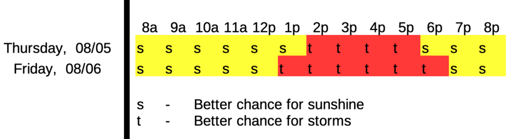
Daily Timeline
Storms will be fewer and farther between today and tomorrow, and mainly confined to the mid-afternoon
Day-to-Day Forecast
Today
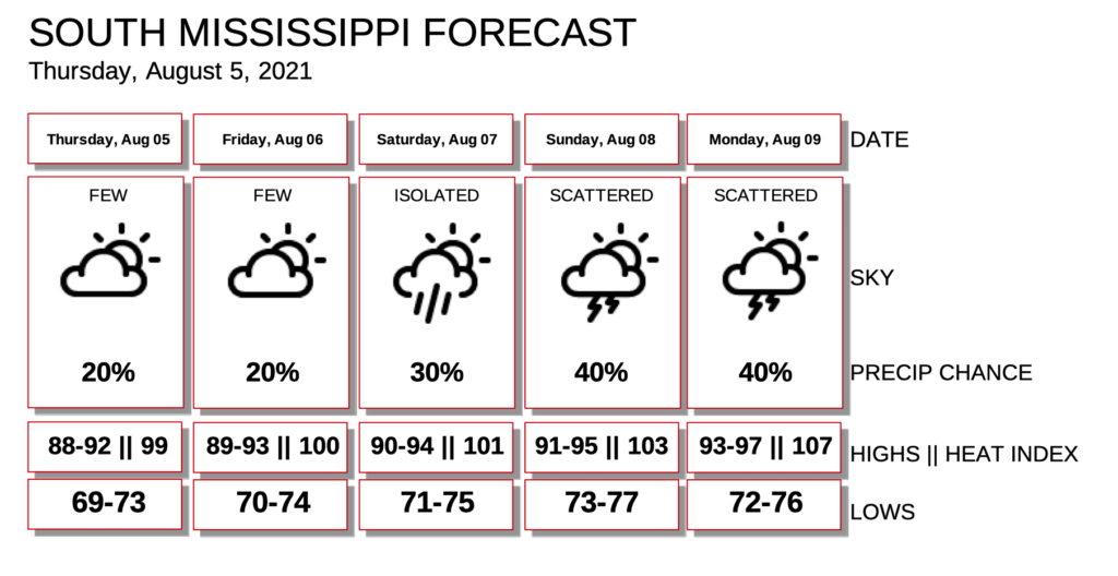
Mostly sunny with a few storms possible. Highs around 90. The chance of rain 20-percent.
Tonight
Partly cloudy. Lows in the lower 70s.
Friday
Partly cloudy with a 20-percent chance for afternoon storms. Highs in the lower 90s.
Friday Night
Mostly clear. Lows in the lower 70s.
Saturday
Passing clouds with a 30-percent chance of showers and thunderstorms in the afternoon. Highs in the lower 90s.
Saturday Night
Mostly clear. Lows in the lower 70s.
Sunday
Mostly sunny with a 40-percent chance of showers and thunderstorms. Highs in the mid 90s.
Sunday Night
Partly cloudy. Lows in the low to mid 70s.
Monday
Mostly sunny with a chance for afternoon storms. Highs in the mid 90s. The chance of rain 40-percent.
Monday Night
Partly cloudy. Lows in the mid 70s.
Tuesday
Mostly sunny with a chance for afternoon storms. Highs in the mid 90s. The chance of rain 40-percent.
Tuesday Night
Partly cloudy. Lows in the mid 70s.
Wednesday
Passing clouds with a chance for afternoon storms. Still warm. Highs in the mid 90s. The chance of rain 30-percent.
Graphical Forecast
Tropics
There are two areas to watch in the Tropics this morning. The National Hurricane Center has highlighted one area in the open Atlantic and another wave coming off the African Coast.

So far, neither of these pose any real risk to the Gulf Coast. As of now. There is some indication that the “Yellow” area may ‘fly under the radar’ so to speak and get closer to Florida, but for the most part we are talking about Fish Storms at the present time.


Yes, tropical update is great!