Overall the weather pattern is about to get a bit more unsettled. It looks like the area will see a few systems passing through every few days and even little clusters of storms from Texas and Arkansas may be zipping by, too.
Thankfully the threat for severe weather within all these chances for rain appears to be on the low end of the scale. We are back to the time of year where it gets a bit more difficult for severe storms to develop across south Mississippi. And even when severe weather does develop, it tends to be due to windy conditions, not tornadoes. Still bad, but more manageable.
Severe Weather Outlook
The threat for severe weather during the next 10 days still looks low. The SPC is highlighting a MArginal-to-Slight Risk for severe weather to the west across parts of Texas and Oklahoma in the coming days, and some of that riff-raff may sneak toward south Mississippi, but it isn’t likely to be “Severe” by the time it gets here.
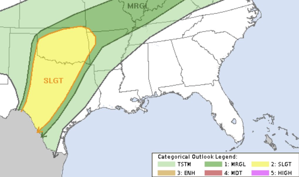


Friday looks to pose the highest risk for severe weather in the short term with another potential Sunday and Monday. But, again, that potential is pretty low. Rain and wind would be the main concern. The tornado threat appears to be very low as the low-level and mid-level wind shear and helicity just don’t appear to be very favorable for the development of tornadoes.
Rainfall Outlook
During the next five days the best bet for rain looks to be on Friday and into Saturday morning and then again Sunday and into Monday.
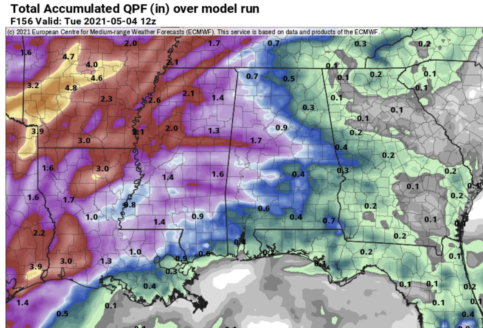
Rainfall totals should be held to between 1/2″ and 3″ in total between now and Tuesday morning. The difference between the two numbers will depend on if your area gets underneath some of the stronger storms on Friday and through the weekend.
Day-by-Day Forecast
Today
Clouds this morning will break up as we get some vertical mixing going through the day. Daytime heating may also drive some cool puffy cumulus clouds and the chance for a pretty sunst for some folks. Highs will top out in the upper 70s and lower 80s. South winds 10 to 15 mph.
Tonight
Clouds will increase again tonight with lows in the mid 60s. Southeast winds 5 to 10 mph.
Thursday
Another mostly cloudy start before things break up a bit and then we look for more increasing clouds through the afternoon and evening. In fact, by dinnertime there may even be a few light showers in the area. Highs will tag the low to mid 80s. South winds 5 to 10 mph. The chance for rain is around 10-percent.
Thursday Night
Slight chance of showers in the evening, then a chance of showers after midnight. Partly cloudy. Lows in the mid 60s. South winds 5 to 10 mph. The chance of rain 30-percent.
Friday
Mostly cloudy with chance of showers and slight chance of thunderstorms. starting around noon. Storms may pack heavy rain, frequent lightning and some occasional gusty wind. So far it looks like the tornado threat is very, very low. Rain will likely stick around through the evening hours.
Highs in the upper 70s. Win will start from the south and flip back around to the north at 5 to 15 mph. The chance of rain is about 60-percent. One the rain moves through, overnight lows in the upper 50s.
Saturday
Things look a bit drier, but not completely dry, on Saturday as the little front/boundary that brought the rain Friday sags into the Gulf. So far, model guidance isn’t too keen on kicking it all the way out of the region, so rain is going to have to hang around in the forecast for Saturday. The good news is the chance you see a shower is pretty low – around 20-percent. Highs will top out around 80. Lows will bottom out in the lower 60s.
Sunday
The next system will likely start to get its act together in east Texas on Sunday qhich means another shot for rain by afternoon and evening. Right now, a 40-percent chance of showers and thunderstorms looks to be prudent, but that may need to be ‘upped’ in the coming days depending on how fast this next system gets organized and moving. the good news is the threat for severe weather looks pretty low with this next system, too… However not as low. This one will need to be monitored for brief spin-up tornadoes and the potential for some flash flooding. Highs will get back into the lower 80s. Lows will be mild, in the mid 60s.
Monday
Lingering showers and storms will be possible as that system moves out. Behind the rain, things will likely remain a bit cloudy. Highs in the upper 70s to low 80s with lows around 60. The chance for rain is 30-percent.
Tuesday
An interesting pattern may develop as we head through next week with multiple rounds of rain possible from decaying MCSs passing through and little ‘shortwave troughs’ zipping by. For the moment, I’ll hold onto a chance for rain, with highs in the mid 80s. The chance of rain 20-percent.
The Bottom Line
The area is headed into a ‘wetter’ pattern. I know, I know… How can it get any wetter? But the weather pattern is going to be set up for multiple passes of little systems through the area starting Friday through – at least – the middle of next week. The good news is that the threat for severe weather looks to remain on the low end of the scale.
Temperatures will be on the rise, too. Highs will be cruising in the 80s most days. and overnight lows only dropping back into the 60s. The humidity will be with us, too.
In fact, this may be the beginning of our “hot and humid” weather that will settle in for the rest of the summer. So if you have been preparing for that to return, your wait is over. If you have been dreading this day… welp, it is looking like it is here.


Thanks for keeping us on top of everything.
A wetter pattern …. when have I NOT seen those words?? I know, Nick, you’re just the messenger. It’s just that the rain, seemingly every other day, gets a bit much after about 6 months. Oh, I don’t know if it’s just due to me using Firefox for my browser, but the graphs for the Severe outlooks and the rain forecast aren’t showing up. Hope your new job is working out so far. We REALLY miss you!
Thank you for this thorough forecast!