Things are quite comfortable this morning across the region. Temperatures fell back into the 50s in spots but most folks woke up this morning around 60-63 degrees.
Just a quick reminder that the forecast area for this forecast is highlighted in green below

There is quite the inversion set-up this morning across the area. An inversion is when warmer air is on top of cooler air. This doesn’t happen much during the day (even though hot air rises) because the Sun does a great job of heating up the ground which keeps the lower atmosphere warmer than the atmosphere above it.
But at night, with no Sun, the atmosphere can cool quick closer to the ground.
Take a look at the sounding from this morning
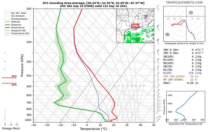
Unsure about how to read the graph, check out the “Hot To Read a Skew-T post!
You can see that the red line that curve toward the bottom gets rather wavy. If you follow the line from top to bottom, as you get to the bottom part where the line goes from right to left is the inversion.
The temperature at the surface is close to 62 degrees. If you go up about 1000ft, the temperature is 71 degrees! If you go up another 1500ft, the temperature falls back down to about 60 degrees.
Forecast models aren’t always the best at predicting this kind of event. More times they are off by a few degrees when talking about an inversion behind a cold front. But this time, they were spot on. Here is the forecast sounding from five days ago.

Notice that there isn’t much difference. Pretty crazy. And nice to see the models do really well.
The same graph above also shows us that there is dry air (the green line and red line are far apart), so we can expect things to heat up pretty quickly today. Temperatures will climb back into the 80s and top out in the mid to upper 80s.
But the humidity won’t be as bad.
Things will stay dry for a few days, before better chances for rain sneak back into the forecast.
Tropical Note
Here is a quick look at the tropics. Everything that is out there right now shouldn’t be much of an issue for the northern Gulf Coast. It looks like the area of interest that will get into the Bay of Campeche will be of a concern for Mexico and Texas than anyone else.
Tropical Weather Outlook
nhc.noaa.gov
NWS National Hurricane Center
Miami FL 800 AM EDT Fri Sep 10 2021
For the North Atlantic…
Caribbean Sea and the Gulf of Mexico: The National Hurricane Center is issuing advisories on Hurricane Larry, located over the western Atlantic several hundred miles southwest of Newfoundland, Canada.
1. The northern portion of a tropical wave is producing disorganized showers and thunderstorms over Honduras, the western Caribbean Sea, and portions of the Yucatan peninsula. This system is forecast to move into the Bay of Campeche and merge with a pre-existing surface trough located over the southwestern Gulf of Mexico by this weekend. Environmental conditions are expected to be conducive to support gradual development, and a tropical depression is likely to form Sunday or Monday before the system moves onshore along the western Gulf of Mexico coast. Regardless of development, this disturbance is expected to produce heavy rains across portions of Central America through Saturday.
* Formation chance through 48 hours…medium…40 percent.
* Formation chance through 5 days…high…70 percent.
2. A strong tropical wave is expected to emerge off of the west coast of Africa by tonight. Environmental conditions are forecast to be conducive for gradual development thereafter, and a tropical depression is likely to form late this weekend or early next week as the system moves west-northwestward over the far eastern Atlantic near the Cabo Verde Islands. Interests in the Cabo Verde Islands should monitor the progress of this system.
* Formation chance through 48 hours…medium…50 percent.
* Formation chance through 5 days…high…70 percent.

Day-to-Day Forecast
Today
Mostly sunny. Highs in the mid to upper 80s.
Tonight
Mostly clear. Lows in the mid 60s.
Saturday
Sunny. Highs in the upper 80s.
Saturday Night
Mostly clear. Lows in the mid 60s.
Sunday
Increasing clouds with a 30-percent for showers and storms. Highs in the upper 80s.
Sunday Night
Partly cloudy. Lows around 70.
Monday
Mostly cloudy with a chance for showers and storms. Highs in the upper 80s. The chance of rain 40-percent.
Monday Night
Partly cloudy. Lows around 70.
Tuesday
Mostly sunny with afternoon storms possible. Highs in the upper 80s. The chance of rain 40 percent.
Tuesday Night
Partly cloudy. Lows in the upper 60s.
Wednesday
Mostly cloudy with a 40-percent chance of showers and thunderstorms. Highs in the upper 80s.
Wednesday Night
Partly cloudy -. Lows around 70.
Thursday
A 30-percent chance of showers and thunderstorms. Mostly sunny. Highs in the upper 80s.
Graphical Forecast


