Hurricane Nicholas made landfall late last night. Yup, Hurricane. A lot like Barry in 2019, it strengthened – just enough – right before landfall.
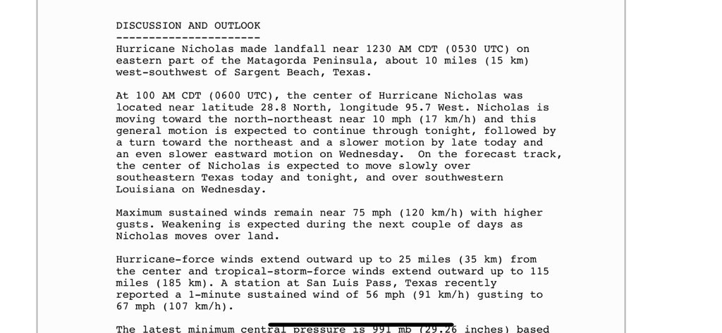
Before you know it, this ‘Nicholas’ will be back in the region. Sadly not me, but now-Tropical Storm Nicholas will be making a visit. By the time it gets there, though, it will likely be a Tropical Depression. Or a remnant low.
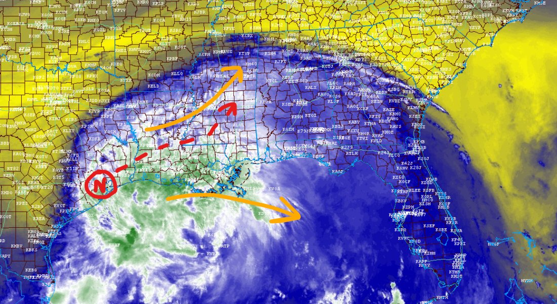
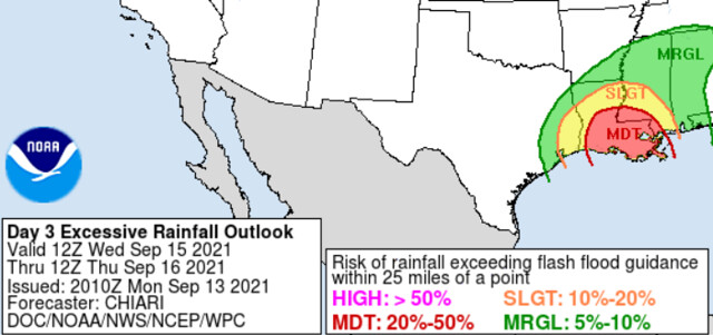
As the eastern edge fans out across parts of the MS/AL/LA region shows, and some thunderstorms, will be possible again today, tomorrow, and Thursday. Rainfall estimates suggest the potential for some flash flooding.
Below, you can see one model depiction of rainfall totals. Like always, don’t take any one point as the total for you, instead use the highest and lowest number to build a “fence” for the potentials for where you live.
In this case, between 3″ and 10″ of rain will be possible between now and Thursday evening. The highest totals toward the coast, but also a few points inland with possible higher totals, too.
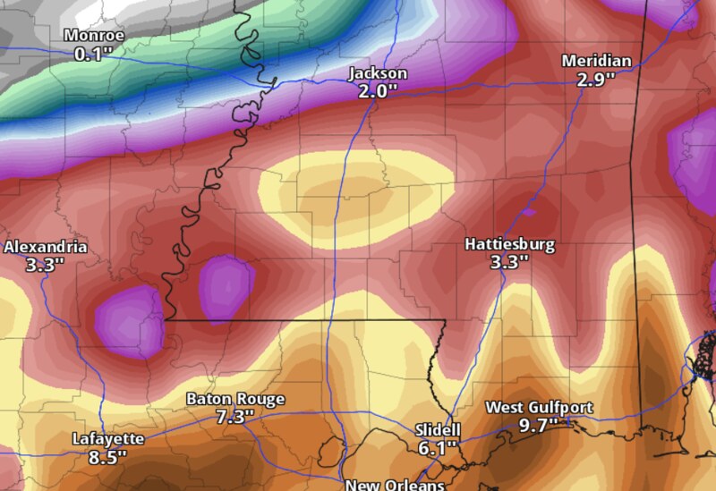
The chance for flooding will be particularly true for folks in Louisiana. The WPC has issued a Moderate Risk (a 3 out of 4) for flash flooding for sections of Louisiana and Mississippi for Wednesday.
I wish I had the time to do a county-by-county breakdown for rainfall, but sadly I don’t this time around. But I will say this…
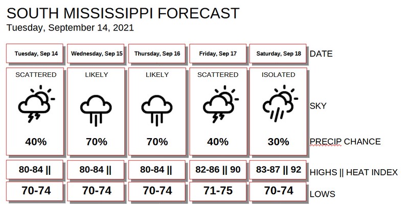
General outlook for Tuesday, Wednesday and Thursday
EVERYONE: Heavy rain at times with wind gusts up to 20mph; Rainfall totals of at least 2″
MANY AREAS: Heavy rain at times with wind gusts up to 30mph; Rainfall totals of at least 4″
SOME PLACES: Multiple rounds of heavy rain with a few wind gusts up to 40mph in the strongest storms; Rainfall totals of at least 6″ and some brief flash flooding
FEW SPOTS: Multiple rounds of heavy rain with a few wind gusts up to 50mph in the strongest storms; Rainfall totals of at least 8″ and flash flooding
Not everyone is going tobe those few spots that see the most rain or the strongest wind from some of these storms. But just about everyone will see some breezy conditions at times and about 2″ of rainfall by the time things are all said and done.
So far the threat for severe weather looks lower, but not zero. It’ll be dependent on how far inland Nicholas gets before reaching the area. The closer to the coast it stays, the lower the risk for severe weather and tropical tornadoes.
Today
Mostly cloudy with chance of showers. Highs in the lower 80s. East winds 5 to 15 mph. The chance of rain 40-percent.
Tonight
Cloudy with a 40-percent chance for overnight tropical showers. Temperatures nearly steady in the lower 70s. East winds 5 to 15 mph.
Wednesday
Mostly cloudy with showers and a few thunderstorms possible. Highs in the lower 80s. East winds 5 to 15 mph. The chance of rain 70-percent.
Wednesday Night
Cloudy with chance of showers. Lows around 70. Southeast winds around 5 to 15 mph. The chance of rain 60-percent.
Thursday
Mostly cloudy with a 60-percent chance for showers and storms. Highs in the lower 80s. Southeast winds 5 to 10 mph. The chance of rain 70-percent.
Thursday Night
Partly cloudy with a 40 percent chance of showers. Lows in the lower 70s.
Friday
Partly cloudy with some lingering storms possible. Highs in the mid 80s. The chance of rain 40-percent.
Friday Night
Partly cloudy. Lows in the lower 70s.
Saturday
Partly cloudy with ‘summertime storms’ possible. Highs in the mid 80s. The chance of rain 30-percent.
Saturday Night
Partly cloudy. Lows in the lower 70s.
Sunday
Partly cloudy with a few storms possible. Highs in the mid 80s. The chance of rain 30-percent.
Sunday Night
Partly cloudy. Lows around 70.
Monday
Partly cloudy with a 30-percent chance of showers and thunderstorms. Highs in the mid 80s.
Graphical Forecast