Today’s forecast for rainfall should be pretty easy. Given that most spots are already seeing rain – there is a 100-percent chance!
Jokes aside, I know many spots don’t need additional rainfall. Model guidance is suggesting between 2″ and 6″ across the region, with some spots picking up as many as 10″ of rain.
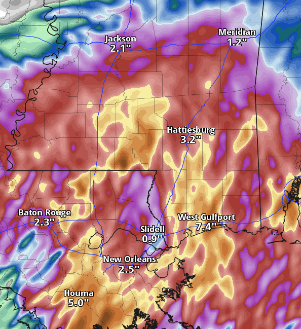
The rain is being caused by the remnants of Nicholas. While technically still a Tropical Depression, it is really just a tropical rainstorm at this point. It will become pretty diffuse during the next 24 hours and likely be pretty tough to make out – aside from the rain.
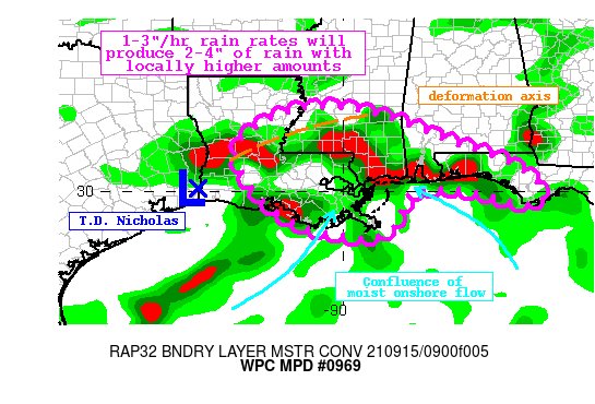
Because of the additional rain, the WPC has issued another Moderate Risk for flash flooding today. Particularly close to the coastline. And a Slight Risk farther inland.

On top of that, they just issued a Mesoscale Precipitation Discussion saying, in part, “Rainfall rates at times may approach 3″/hr in bands rotating onshore, and widespread 2-4″ of rain is likely. Locally much higher amounts, possibly exceeding 6″, are also possible. Flash flooding is likely.”
Remember, if you come across water over the road, the NWS says, “turn around, don’t drown.”
You never know how much of the road is left underneath a flooded road. Nor can you see if there is any debris there, either. So it is always best to find another way around.
Also today, tropical tornadoes will be possible mainly along the coast. These are often EF-0 and EF-1 tornadoes that are on the ground for only a few minutes and then they are gone. They often only cause tree damage. Thankfully, very rarely are they strong enough to cause major direct damage to buildings.
But they are known to knock down trees, power lines, frences, and blow some shingles off of roofs.
Looking out a bit further in time, there is some model data suggesting an actual cold front may try and swing through the area. As of now, it doesn’t look like it will knock back temperatures that much, but it does look like it would kick this tropical airmass back to where it belongs – the Tropics.
But if you guys know me, you also know how I feel about these “First fall cold fronts” in September: I’ll believe it when I see it.
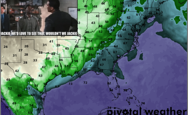
The ECMWF model is suggesting a pretty potent shot of drier air (above). The meme in the upper left-hand corner is a clip from the outtakes of the movie Rush Hour 2 with Jackie Chan and Chris Tucker. If you’re unfamiliar, in the scene Chris is facetiously goading another character. But in the outtakes, he kept calling Jackie Chan by his real name, not his character, in the scene.
And it sums up how I feel about these early-fall cold fronts.
Day-to-Day Forecast
Today
Mostly cloudy with rainfall off and on all day long. Highs in the near 80. East winds 5 to 10 mph. The chance of rain 100-percent.
Tonight
Mostly cloudy. Temperatures nearly steady in the lower 70s. The chance of rain 60-percent.
Thursday
Mostly cloudy with more rain possible. Highs in the lower 80s. The chance of rain 60-percent.
Thursday Night
Partly cloudy with a 40-percent chance of showers and thunderstorms. Lows in the lower 70s.
Friday
Partly cloudy with summertime storms possible. Highs in the lower 80s. The chance of rain 60-percent.
Friday Night
Partly cloudy. Lows in the lower 70s. The chance of rain 30-percent.
Saturday
Partly cloudy with afternoon storms possible. Highs in the mid 80s. The chance of rain 40-percent.
Saturday Night
Partly cloudy. Lows around 70.
Sunday
Partly cloudy with a few rounds of rain possible. Highs in the lower 80s. The chance of rain 40-percent.
Sunday Night
Partly cloudy. Lows in the lower 70s.
Monday
Partly cloudy with scattered storms possible. Highs in the mid 80s. The chance of rain 40-percent.
Monday Night
Partly cloudy. Lows in the lower 70s.
Tuesday
Passing clouds with passing storms possible. Highs in the mid 80s. The chance of rain 30-percent.


Then, I’m sorry to burst your bubble but, late last week, we ‘did’ have a ‘first Fall cold front’ come through. It gave us 2 or 3 nice cool mornings … felt nice! I guess you couldn’t see it being over in Houston and not here.