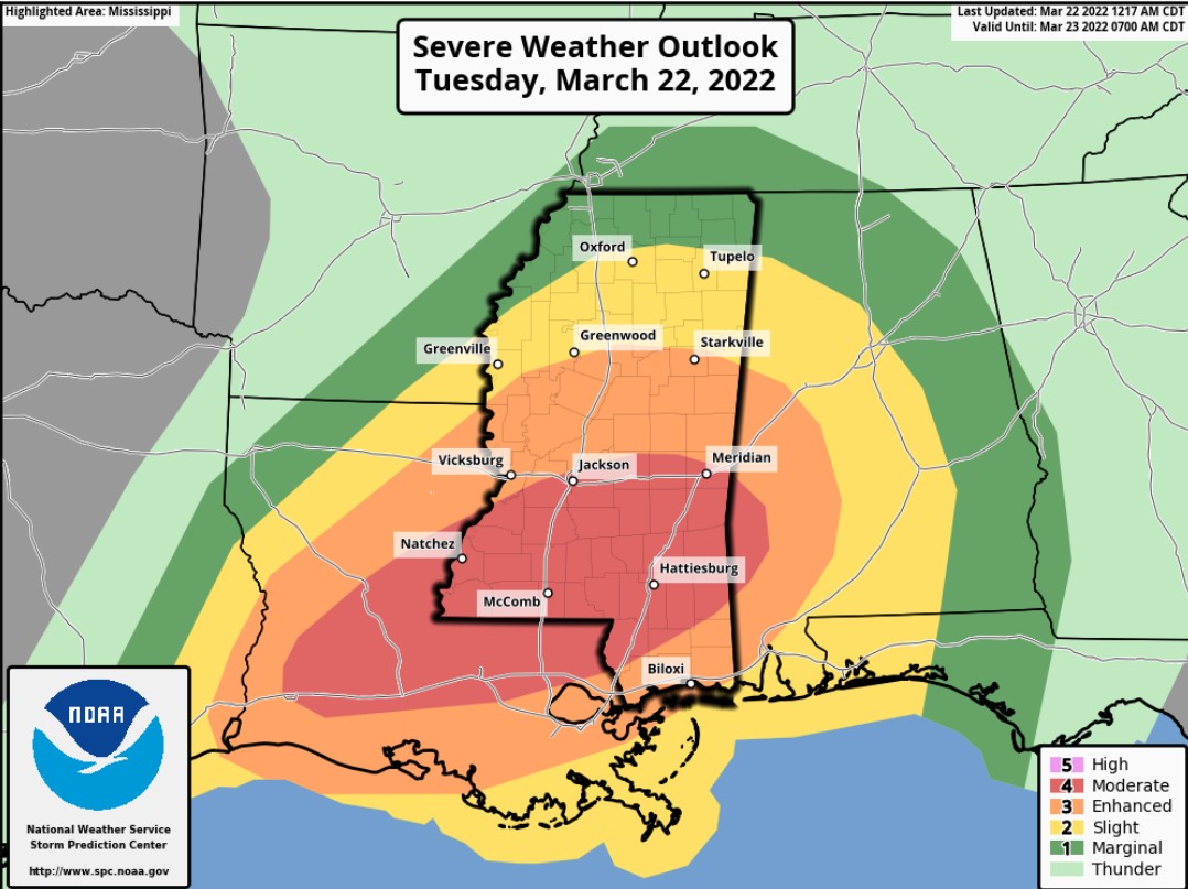
Showers, thunderstorms, severe weather all possible today across the region. The SPC has expanded the Moderate Risk, a “4” on the 1-to-5 scale where “5” is the highest risk for the most significant severe weather, to include a larger swath of Mississippi, Louisiana and into Alabama.
The CIPS Analogs is showing that historical analogs suggest that the highest tornado threat is smack in the middle of the Moderate Risk.

Looking at the Wind Risk and Tornado Risk from the SPC, and the bullseye for wind is across southern Mississippi with the tornado risk stretched from Louisiana through Mississippi and clipping Alabama.


During this (and previous) event, people have asked if there is a way to “‘help’ or ‘say thanks’ for all of the forecasting work I do. For the longest time I said, ‘nah! I just like doing this! You know, to help!’ But I was recently convinced that others want to ‘help’ in their own way, too.
And their way of helping, or simply saying ‘thank you’ is with a donation to the blog to help keep it running – or to help keep me running. So I’ve added this link. If you are one of those people, let me say thank you to YOU.
The timeline and threats for each county are below.
County-by-County Timeline
This will likely be the last county-by-county breakdown I do for this evening. the timeline has sped up by a few hours based on the timeline thus far across parts of Texas and the speed at which model guidance has increase, too.
Louisiana
St. Helena Parish
Tuesday 8a-2p — Isolated showers with few rumbles of thunder developing early, very few (if any) storms may be strong to severe before 10a. Main threats with any storm will be heavy rain, frequent lightning, gusty wind, small hail, and a tornado can not be ruled out.
Tuesday 2p-8p — Showers and storms likely, many strong with a handful severe. Main threats with stronger storms will be very heavy rain, frequent lightning, wind gusts up to 70mph, hail up to the size of quarters, and the potential for a tornado (up to EF3 in strength).
Tuesday 8p-Wednesday 2a — Storms ending. Turning cooler and breezy.
Tangipahoa Parish
Tuesday 8a-2p — Isolated showers with few rumbles of thunder developing early, very few (if any) storms may be strong to severe before 10a. Main threats with any storm will be heavy rain, frequent lightning, gusty wind, small hail, and a tornado can not be ruled out.
Tuesday 2p-8p — Showers and storms likely, many strong with a handful severe. Main threats with stronger storms will be very heavy rain, frequent lightning, wind gusts up to 70mph, hail up to the size of quarters, and the potential for a tornado (up to EF3 in strength).
Tuesday 8p-Wednesday 2a — Storms ending. Turning cooler and breezy.
Washington Parish
Tuesday 8a-2p — Isolated showers with few rumbles of thunder developing early, very few (if any) storms may be strong to severe before 10a. Main threats with any storm will be heavy rain, frequent lightning, gusty wind, small hail, and a tornado can not be ruled out.
Tuesday 2p-8p — Showers and storms likely, many strong with a handful severe. Main threats with stronger storms will be very heavy rain, frequent lightning, wind gusts up to 70mph, hail up to the size of quarters, and the potential for a tornado (up to EF3 in strength).
Tuesday 8p-Wednesday 2a — Storms ending. Turning cooler and breezy.
Livingston Parish
Tuesday 8a-2p — Isolated showers with few rumbles of thunder developing early, very few (if any) storms may be strong to severe before 10a. Main threats with any storm will be heavy rain, frequent lightning, gusty wind, small hail, and a tornado can not be ruled out.
Tuesday 2p-8p — Showers and storms likely, many strong with a handful severe. Main threats with stronger storms will be very heavy rain, frequent lightning, wind gusts up to 70mph, hail up to the size of quarters, and the potential for a tornado (up to EF3 in strength).
Tuesday 8p-Wednesday 2a — Storms ending. Turning cooler and breezy.
St. Tammany Parish
Tuesday 8a-2p — Isolated showers with few rumbles of thunder developing early, very few (if any) storms may be strong to severe before 10a. Main threats with any storm will be heavy rain, frequent lightning, gusty wind, small hail, and a tornado can not be ruled out.
Tuesday 2p-8p — Showers and storms likely, many strong with a handful severe. Main threats with stronger storms will be very heavy rain, frequent lightning, wind gusts up to 70mph, hail up to the size of quarters, and the potential for a tornado (up to EF3 in strength).
Tuesday 8p-Wednesday 2a — Storms ending. Turning cooler and breezy.
Mississippi
NEAR I-20
Copiah County
Tuesday 8a-2p — Isolated showers with few rumbles of thunder developing early, very few (if any) storms may be strong to severe before 1p. Main threats with any storm will be heavy rain, frequent lightning, gusty wind, small hail, and a tornado can not be ruled out.
Tuesday 2p-8p — Showers and storms likely, many strong with a handful severe. Main threats with stronger storms will be very heavy rain, frequent lightning, wind gusts up to 70mph, hail up to the size of quarters, and the potential for a tornado (up to EF4 in strength).
Tuesday 8p-Wednesday 2a — Storms ending. Turning cooler and breezy.
Simpson County
Tuesday 8a-2p — Isolated showers with few rumbles of thunder developing early, very few (if any) storms may be strong to severe before 1p. Main threats with any storm will be heavy rain, frequent lightning, gusty wind, small hail, and a tornado can not be ruled out.
Tuesday 2p-8p — Showers and storms likely, many strong with a handful severe. Main threats with stronger storms will be very heavy rain, frequent lightning, wind gusts up to 70mph, hail up to the size of quarters, and the potential for a tornado (up to EF4 in strength).
Tuesday 8p-Wednesday 2a — Storms ending. Turning cooler and breezy.
Smith County
Tuesday 8a-2p — Isolated showers with few rumbles of thunder developing early, very few (if any) storms may be strong to severe before 1p. Main threats with any storm will be heavy rain, frequent lightning, gusty wind, small hail, and a tornado can not be ruled out.
Tuesday 2p-8p — Showers and storms likely, many strong with a handful severe. Main threats with stronger storms will be very heavy rain, frequent lightning, wind gusts up to 70mph, hail up to the size of quarters, and the potential for a tornado (up to EF4 in strength).
Tuesday 8p-Wednesday 2a — Storms ending. Turning cooler and breezy.
Jasper County
Tuesday 8a-2p — Isolated showers with few rumbles of thunder developing early, very few (if any) storms may be strong to severe before 1p. Main threats with any storm will be heavy rain, frequent lightning, gusty wind, small hail, and a tornado can not be ruled out.
Tuesday 2p-8p — Showers and storms likely, many strong with a handful severe. Main threats with stronger storms will be very heavy rain, frequent lightning, wind gusts up to 70mph, hail up to the size of quarters, and the potential for a tornado (up to EF4 in strength).
Tuesday 8p-Wednesday 2a — Storms ending. Turning cooler and breezy.
Clarke County
Tuesday 8a-2p — Isolated showers with few rumbles of thunder developing, very few (if any) storms may be strong to severe. Main threats with any storm will be heavy rain, frequent lightning, gusty wind, small hail, and a tornado can not be ruled out.
Tuesday 2p-8p — Showers and storms likely, many strong with a handful severe. Main threats with stronger storms will be very heavy rain, frequent lightning, wind gusts up to 70mph, hail up to the size of quarters, and the potential for a tornado (up to EF4 in strength).
Tuesday 8p-Wednesday 2a — Showers and storms likely, many strong with a handful severe. Main threats with stronger storms will be very heavy rain, frequent lightning, wind gusts up to 70mph, hail up to the size of quarters, and the potential for a tornado (up to EF2 in strength).
Wednesday 2a-8a — Storms ending. Turning cooler and breezy.
HIGHWAY 84 CORRIDOR
Lincoln County
Tuesday 8a-2p — Isolated showers with few rumbles of thunder developing early, very few (if any) storms may be strong to severe before 1p. Main threats with any storm will be heavy rain, frequent lightning, gusty wind, small hail, and a tornado can not be ruled out.
Tuesday 2p-8p — Showers and storms likely, many strong with a handful severe. Main threats with stronger storms will be very heavy rain, frequent lightning, wind gusts up to 70mph, hail up to the size of quarters, and the potential for a tornado (up to EF4 in strength).
Tuesday 8p-Wednesday 2a — Storms ending. Turning cooler and breezy.
Lawrence County
Tuesday 8a-2p — Isolated showers with few rumbles of thunder developing early, very few (if any) storms may be strong to severe before 1p. Main threats with any storm will be heavy rain, frequent lightning, gusty wind, small hail, and a tornado can not be ruled out.
Tuesday 2p-8p — Showers and storms likely, many strong with a handful severe. Main threats with stronger storms will be very heavy rain, frequent lightning, wind gusts up to 70mph, hail up to the size of quarters, and the potential for a tornado (up to EF4 in strength).
Tuesday 8p-Wednesday 2a — Storms ending. Turning cooler and breezy.
Jeff Davis County
Tuesday 8a-2p — Isolated showers with few rumbles of thunder developing early, very few (if any) storms may be strong to severe before 1p. Main threats with any storm will be heavy rain, frequent lightning, gusty wind, small hail, and a tornado can not be ruled out.
Tuesday 2p-8p — Showers and storms likely, many strong with a handful severe. Main threats with stronger storms will be very heavy rain, frequent lightning, wind gusts up to 70mph, hail up to the size of quarters, and the potential for a tornado (up to EF4 in strength).
Tuesday 8p-Wednesday 2a — Storms ending. Turning cooler and breezy.
Covington County
Tuesday 8a-2p — Isolated showers with few rumbles of thunder developing early, very few (if any) storms may be strong to severe before 1p. Main threats with any storm will be heavy rain, frequent lightning, gusty wind, small hail, and a tornado can not be ruled out.
Tuesday 2p-8p — Showers and storms likely, many strong with a handful severe. Main threats with stronger storms will be very heavy rain, frequent lightning, wind gusts up to 70mph, hail up to the size of quarters, and the potential for a tornado (up to EF4 in strength).
Tuesday 8p-Wednesday 2a — Storms ending. Turning cooler and breezy.
Jones County
Tuesday 8a-2p — Isolated showers with few rumbles of thunder developing early, very few (if any) storms may be strong to severe before 1p. Main threats with any storm will be heavy rain, frequent lightning, gusty wind, small hail, and a tornado can not be ruled out.
Tuesday 2p-8p — Showers and storms likely, many strong with a handful severe. Main threats with stronger storms will be very heavy rain, frequent lightning, wind gusts up to 70mph, hail up to the size of quarters, and the potential for a tornado (up to EF4 in strength).
Tuesday 8p-Wednesday 2a — Storms ending. Turning cooler and breezy.
Wayne County
Tuesday 8a-2p — Isolated showers with few rumbles of thunder developing, very few (if any) storms may be strong to severe. Main threats with any storm will be heavy rain, frequent lightning, gusty wind, small hail, and a tornado can not be ruled out.
Tuesday 2p-8p — Showers and storms likely, many strong with a handful severe. Main threats with stronger storms will be very heavy rain, frequent lightning, wind gusts up to 70mph, hail up to the size of quarters, and the potential for a tornado (up to EF4 in strength).
Tuesday 8p-Wednesday 2a — Showers and storms likely, many strong with a handful severe. Main threats with stronger storms will be very heavy rain, frequent lightning, wind gusts up to 70mph, hail up to the size of quarters, and the potential for a tornado (up to EF2 in strength).
Wednesday 2a-8a — Storms ending. Turning cooler and breezy.
HIGHWAY 98 CORRIDOR
Pike County
Tuesday 8a-2p — Isolated showers with few rumbles of thunder developing early, very few (if any) storms may be strong to severe before 1p. Main threats with any storm will be heavy rain, frequent lightning, gusty wind, small hail, and a tornado can not be ruled out.
Tuesday 2p-8p — Showers and storms likely, many strong with a handful severe. Main threats with stronger storms will be very heavy rain, frequent lightning, wind gusts up to 70mph, hail up to the size of quarters, and the potential for a tornado (up to EF4 in strength).
Tuesday 8p-Wednesday 2a — Storms ending. Turning cooler and breezy.
Walthall County
Tuesday 8a-2p — Isolated showers with few rumbles of thunder developing early, very few (if any) storms may be strong to severe before 1p. Main threats with any storm will be heavy rain, frequent lightning, gusty wind, small hail, and a tornado can not be ruled out.
Tuesday 2p-8p — Showers and storms likely, many strong with a handful severe. Main threats with stronger storms will be very heavy rain, frequent lightning, wind gusts up to 70mph, hail up to the size of quarters, and the potential for a tornado (up to EF4 in strength).
Tuesday 8p-Wednesday 2a — Storms ending. Turning cooler and breezy.
Marion County
Tuesday 8a-2p — Isolated showers with few rumbles of thunder developing early, very few (if any) storms may be strong to severe before 1p. Main threats with any storm will be heavy rain, frequent lightning, gusty wind, small hail, and a tornado can not be ruled out.
Tuesday 2p-8p — Showers and storms likely, many strong with a handful severe. Main threats with stronger storms will be very heavy rain, frequent lightning, wind gusts up to 70mph, hail up to the size of quarters, and the potential for a tornado (up to EF4 in strength).
Tuesday 8p-Wednesday 2a — Storms ending. Turning cooler and breezy.
Lamar County
Tuesday 8a-2p — Isolated showers with few rumbles of thunder developing early, very few (if any) storms may be strong to severe before 1p. Main threats with any storm will be heavy rain, frequent lightning, gusty wind, small hail, and a tornado can not be ruled out.
Tuesday 2p-8p — Showers and storms likely, many strong with a handful severe. Main threats with stronger storms will be very heavy rain, frequent lightning, wind gusts up to 70mph, hail up to the size of quarters, and the potential for a tornado (up to EF4 in strength).
Tuesday 8p-Wednesday 2a — Storms ending. Turning cooler and breezy.
Forrest County
Tuesday 8a-2p — Isolated showers with few rumbles of thunder developing early, very few (if any) storms may be strong to severe before 1p. Main threats with any storm will be heavy rain, frequent lightning, gusty wind, small hail, and a tornado can not be ruled out.
Tuesday 2p-8p — Showers and storms likely, many strong with a handful severe. Main threats with stronger storms will be very heavy rain, frequent lightning, wind gusts up to 70mph, hail up to the size of quarters, and the potential for a tornado (up to EF4 in strength).
Tuesday 8p-Wednesday 2a — Storms ending. Turning cooler and breezy.
Perry County
Tuesday 8a-2p — Isolated showers with few rumbles of thunder developing early, very few (if any) storms may be strong to severe before 1p. Main threats with any storm will be heavy rain, frequent lightning, gusty wind, small hail, and a tornado can not be ruled out.
Tuesday 2p-8p — Showers and storms likely, many strong with a handful severe. Main threats with stronger storms will be very heavy rain, frequent lightning, wind gusts up to 70mph, hail up to the size of quarters, and the potential for a tornado (up to EF4 in strength).
Tuesday 8p-Wednesday 2a — Storms ending. Turning cooler and breezy.
Greene County
Tuesday 8a-2p — Isolated showers with few rumbles of thunder developing, very few (if any) storms may be strong to severe. Main threats with any storm will be heavy rain, frequent lightning, gusty wind, small hail, and a tornado can not be ruled out.
Tuesday 2p-8p — Showers and storms likely, many strong with a handful severe. Main threats with stronger storms will be very heavy rain, frequent lightning, wind gusts up to 70mph, hail up to the size of quarters, and the potential for a tornado (up to EF3 in strength).
Tuesday 8p-Wednesday 2a — Showers and storms likely, many strong with a handful severe. Main threats with stronger storms will be very heavy rain, frequent lightning, wind gusts up to 70mph, hail up to the size of quarters, and the potential for a tornado (up to EF2 in strength).
Wednesday 2a-8a — Storms ending. Turning cooler and breezy.
HIGHWAY 26 CORRIDOR
Pearl River County
Tuesday 8a-2p — Isolated showers with few rumbles of thunder developing, very few (if any) storms may be strong to severe. Main threats with any storm will be heavy rain, frequent lightning, gusty wind, small hail, and a tornado can not be ruled out.
Tuesday 2p-8p — Showers and storms likely, many strong with a handful severe. Main threats with stronger storms will be very heavy rain, frequent lightning, wind gusts up to 70mph, hail up to the size of quarters, and the potential for a tornado (up to EF3 in strength).
Tuesday 8p-Wednesday 2a — Showers and storms likely, many strong with a handful severe. Main threats with stronger storms will be very heavy rain, frequent lightning, wind gusts up to 70mph, hail up to the size of quarters, and the potential for a tornado (up to EF2 in strength).
Wednesday 2a-8a — Storms ending. Turning cooler and breezy.
Stone County
Tuesday 8a-2p — Isolated showers with few rumbles of thunder developing, very few (if any) storms may be strong to severe. Main threats with any storm will be heavy rain, frequent lightning, gusty wind, small hail, and a tornado can not be ruled out.
Tuesday 2p-8p — Showers and storms likely, many strong with a handful severe. Main threats with stronger storms will be very heavy rain, frequent lightning, wind gusts up to 70mph, hail up to the size of quarters, and the potential for a tornado (up to EF3 in strength).
Tuesday 8p-Wednesday 2a — Showers and storms likely, many strong with a handful severe. Main threats with stronger storms will be very heavy rain, frequent lightning, wind gusts up to 70mph, hail up to the size of quarters, and the potential for a tornado (up to EF2 in strength).
Wednesday 2a-8a — Storms ending. Turning cooler and breezy.
George County
Tuesday 8a-2p — Isolated showers with few rumbles of thunder developing, very few (if any) storms may be strong to severe. Main threats with any storm will be heavy rain, frequent lightning, gusty wind, small hail, and a tornado can not be ruled out.
Tuesday 2p-8p — Showers and storms likely, many strong with a handful severe. Main threats with stronger storms will be very heavy rain, frequent lightning, wind gusts up to 70mph, hail up to the size of quarters, and the potential for a tornado (up to EF3 in strength).
Tuesday 8p-Wednesday 2a — Showers and storms likely, many strong with a handful severe. Main threats with stronger storms will be very heavy rain, frequent lightning, wind gusts up to 70mph, hail up to the size of quarters, and the potential for a tornado (up to EF2 in strength).
Wednesday 2a-8a — Storms ending. Turning cooler and breezy.
COASTAL MISSISSIPPI
Jackson County
Tuesday 8a-2p — Isolated showers with few rumbles of thunder developing, very few (if any) storms may be strong to severe. Main threats with any storm will be heavy rain, frequent lightning, gusty wind, small hail, and a tornado can not be ruled out.
Tuesday 2p-8p — Showers and storms likely, many strong with a handful severe. Main threats with stronger storms will be very heavy rain, frequent lightning, wind gusts up to 70mph, hail up to the size of quarters, and the potential for a tornado (up to EF2 in strength).
Tuesday 8p-Wednesday 2a — Showers and storms ending. Few remaining storms will be strong, very few, if any, will be severe. Main threats with any storm will be heavy rain, frequent lightning, gusty wind, small hail, and a tornado can not be ruled out.
Wednesday 2a-8a — Turning cooler and breezy.
Harrison County
Tuesday 8a-2p — Isolated showers with few rumbles of thunder developing, very few (if any) storms may be strong to severe. Main threats with any storm will be heavy rain, frequent lightning, gusty wind, small hail, and a tornado can not be ruled out.
Tuesday 2p-8p — Showers and storms likely, many strong with a handful severe. Main threats with stronger storms will be very heavy rain, frequent lightning, wind gusts up to 70mph, hail up to the size of quarters, and the potential for a tornado (up to EF2 in strength).
Tuesday 8p-Wednesday 2a — Showers and storms ending. Few remaining storms will be strong, very few, if any, will be severe. Main threats with any storm will be heavy rain, frequent lightning, gusty wind, small hail, and a tornado can not be ruled out.
Wednesday 2a-8a — Turning cooler and breezy.
Hancock County
Tuesday 8a-2p — Isolated showers with few rumbles of thunder developing, very few (if any) storms may be strong to severe. Main threats with any storm will be heavy rain, frequent lightning, gusty wind, small hail, and a tornado can not be ruled out.
Tuesday 2p-8p — Showers and storms likely, many strong with a handful severe. Main threats with stronger storms will be very heavy rain, frequent lightning, wind gusts up to 70mph, hail up to the size of quarters, and the potential for a tornado (up to EF2 in strength).
Tuesday 8p-Wednesday 2a — Showers and storms ending. Few remaining storms will be strong, very few, if any, will be severe. Main threats with any storm will be heavy rain, frequent lightning, gusty wind, small hail, and a tornado can not be ruled out.
Wednesday 2a-8a — Turning cooler and breezy.
Alabama
Sumter County
Tuesday 10a-4p — Isolated showers with few rumbles of thunder developing, very few (if any) storms may be strong to severe. Main threats with any storm will be heavy rain, frequent lightning, gusty wind, small hail, and a tornado can not be ruled out.
Tuesday 4p-10p — Showers and storms likely, many strong with a handful severe. Main threats with stronger storms will be very heavy rain, frequent lightning, wind gusts up to 70mph, hail up to the size of quarters, and the potential for a tornado (up to EF4 in strength).
Tuesday 10p-Wednesday 4a — Showers and storms likely, many strong with a handful severe. Main threats with stronger storms will be very heavy rain, frequent lightning, wind gusts up to 70mph, hail up to the size of quarters, and the potential for a tornado (up to EF3 in strength).
Wednesday 4a-10a — Storms ending. Turning cooler and breezy.
Choctaw County
Tuesday 10a-4p — Isolated showers with few rumbles of thunder developing, very few (if any) storms may be strong to severe. Main threats with any storm will be heavy rain, frequent lightning, gusty wind, small hail, and a tornado can not be ruled out.
Tuesday 4p-10p — Showers and storms likely, many strong with a handful severe. Main threats with stronger storms will be very heavy rain, frequent lightning, wind gusts up to 70mph, hail up to the size of quarters, and the potential for a tornado (up to EF4 in strength).
Tuesday 10p-Wednesday 4a — Showers and storms likely, many strong with a handful severe. Main threats with stronger storms will be very heavy rain, frequent lightning, wind gusts up to 70mph, hail up to the size of quarters, and the potential for a tornado (up to EF3 in strength).
Wednesday 4a-10a — Storms ending. Turning cooler and breezy.
Washington County
Tuesday 10a-4p — Isolated showers with few rumbles of thunder developing, very few (if any) storms may be strong to severe. Main threats with any storm will be heavy rain, frequent lightning, gusty wind, small hail, and a tornado can not be ruled out.
Tuesday 4p-10p — Showers and storms likely, many strong with a handful severe. Main threats with stronger storms will be very heavy rain, frequent lightning, wind gusts up to 70mph, hail up to the size of quarters, and the potential for a tornado (up to EF4 in strength).
Tuesday 10p-Wednesday 4a — Showers and storms likely, many strong with a handful severe. Main threats with stronger storms will be very heavy rain, frequent lightning, wind gusts up to 70mph, hail up to the size of quarters, and the potential for a tornado (up to EF3 in strength).
Wednesday 4a-10a — Storms ending. Turning cooler and breezy.


