Looking at the data from last night and yesterday afternoon, my concern for severe weather as we close out 2022 isn’t terribly high. Storms? Yes. Flooding? Maybe. Severe weather? I’m not sold, yet.
But it’ll be close. How close?
Well, according to the GFS computer weather model from yesterday afternoon… razor close.

We check all the boxes, except it is just a hair too cold at the surface. If we were to take the data above and add five degrees to the surface temperature, and three degrees to the 850mb temperature, we would have a primo severe weather setup.
That isn’t a big difference in the grand scheme of things when looking at computer data for an event four days out. But ti is enough to make me hesitate about any ‘true’ slam dunk threat for severe weather. The operational guidance just doesn’t support it right now.
Looking at the ensemble data, the CIPS Analogs out of Saint Louis University suggest the potential for severe weather exists, as well as the potential for tornadoes.


The CIPS ‘sees’ this because it takes into account different parameters (including the above-mentioned example) and re-runs the same model a few dozen times and then assesses a risk based on all of that. And while CIPS is pretty good, I think there are times (like this) when it may have a tendency to ‘see’ things that aren’t there due to the nature of how it is constructed.
But, even if there isn’t severe weather, there will still be storms. And some gusty wind.
And rain. Whoa nelly, will there be some rain.
In fact, looking at the National Blend of Models data from the NWS, the ‘reasonable worst case scenario’ data from yesterday looked rather robust during the next 10 days.
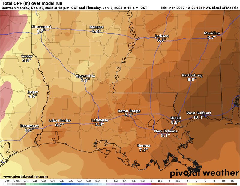
No, your eyes do not deceive you, that is model guidance suggesting more than 10″ of rain across parts of the region during the next 10 days. So, the rain may become a bigger story than the threat for severe weather if this guidance holds. While the ground can probably handle most of that rain, it wouldn’t be able to handle all of it, and we would likely see some localized flooding in some spots.
The chance for flooding would be mainly on Friday of this week and Tuesday of next week. This, too, is not a ‘slam dunk’ by any means, but is certainly one of the cards on the table.
DAY TO DAY FORECAST
Tuesday
Sunny. Highs in the mid 50s.
Tuesday Night
Mostly clear. Lows in the mid 30s.
Wednesday
Sunny. Not as cool with highs in the upper 60s.
Wednesday Night
Partly cloudy with some patchy fog after midnight. Lows around 50.
Thursday
Patchy fog in the morning. Mostly sunny. Highs in the lower 70s.
Thursday Night
Increasing clouds with a few showers possible overnight. Lows in the upper 50s. Chance of rain 20 percent.
Friday
Cloudy with showers and storms likely. Severe weather can’t be ruled out. Highs in the lower 70s. Chance of rain 80 percent.
Friday Night
Lingering showers and storms. Lows in the lower 60s. Chance of rain 60 percent.
Saturday
Mostly cloudy with more showers and storms possible. Highs in the lower 70s. Chance of rain 60 percent.
Saturday Night
Mostly cloudy. Lows in the mid 50s.
New Years Day
Mostly sunny. Highs in the lower 70s.
Sunday Night
Partly cloudy. Lows around 60.
Monday
Mostly cloudy with some showers possible. Highs in the mid 70s. Chance of rain 30 percent.


