The SPC has held the Moderate Risk for severe weather this morning for the area. That is a “4” on the 1-to-5 scale where a “5” is the highest risk for the most significant severe weather.
I’m both surprised, and not surprised by that. I’m surprised they didn’t shift it a bit more south and slim is down a bit. I am also not surprised they left it as-is, since they tend to hold a forecast until they are 100% certain it won’t happen.
That plan of action is both good and bad.
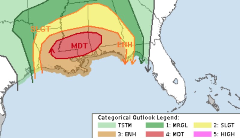
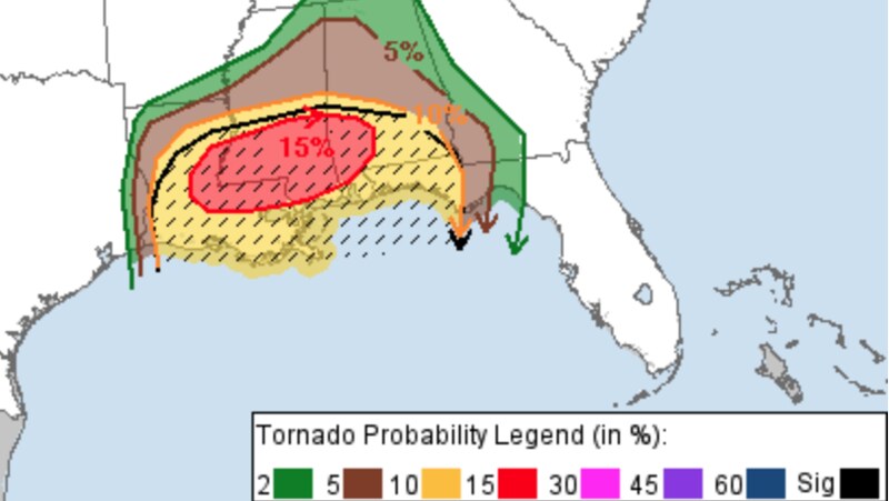
The images above show the SPC risk for today for both categorical and probability for tornado. The area is under a “15% hatched” which means we are about 20x more likely to see a tornado in the area than any other day. And there is an increased risk for that tornado to be EF2 or stronger.
But I am more concerned about the rain and the wind than the tornado threat. Because I think everyone gets rain and wind. And only a select few will have the chance for a tornado – specifically a strong tornado.
In fact, I think my general forecast from the other day still holds:
EVERYONE — Brief heavy rain, some lightning, wind gusts up to 45mph
MOST FOLKS — A few rounds of brief heavy rain, brief localized flash flooding, lightning, wind gusts up to 50mph
SOME SPOTS — A few rounds of extended heavy rain, brief flash flooding, a lot of lightning, wind gusts up to 60mph, small hail
FEW PLACES — A few rounds of extended heavy rain, brief flash flooding, a lot of lightning, wind gusts up to 65mph, quarter-sized sized hail
VERY SELECT LOCATIONS — A few rounds of extended heavy rain, brief flash flooding, a lot of lightning, wind gusts up to 75mph, half dollar-sized sized hail and a tornado (up to EF3 in strength)
I still think everyone sees a good bit of rain, some lightning, and wind gusts that can knock down weakly-rooted trees and bring down old branches. That is why I’m also a bit concerned about power outages, too. Many rural spots where tree-lined roads also have the power lines may have some issues with trees and limbs across lines.
I would prepare to lose power as this lines kicks through today – for some it’ll be for a few minutes, for others it may be a few hours. If you rely on power for any medical devices, please keep that in mind.
The timeline has shifted up a bit – not by much – to be around midday instead of in the afternoon.
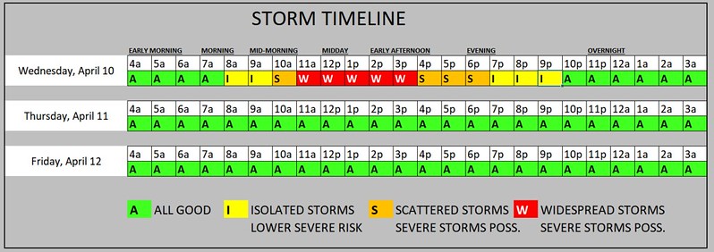
Some of the isolated showers and storms may also linger a bit later into the evening. Though, I believe the true severe threat will come to an end by around 5p.
REGIONAL DAY TO DAY FORECAST
Wednesday: Showers likely with a chance of thunderstorms in the morning, then showers with thunderstorms likely in the afternoon. Some thunderstorms may be severe. Locally heavy rainfall possible in the afternoon. Highs in the mid 70s. Southeast winds 15 to 20 mph with gusts up to 30 mph. Chance of rain near 100 percent.
Wednesday Night: Showers and thunderstorms likely, mainly in the evening. Some thunderstorms may be severe. Lows in the upper 50s. South winds 15 to 20 mph, becoming southwest 10 to 15 mph after midnight. Chance of rain 70 percent.
Thursday: Mostly sunny and breezy and less humid with highs in the mid 70s. West winds 15 to 25 mph with gusts up to 40 mph.
Thursday Night: Clear, cooler with lows in the upper 40s.
Friday: Sunny. Highs in the upper 70s.
Friday Night: Mostly clear. Lows in the upper 40s.
Saturday: Sunny. Highs in the lower 80s.
Saturday Night: Mostly clear. Lows in the lower 50s.
Sunday: Mostly sunny. Highs in the lower 80s.
Sunday Night: Partly cloudy. Lows in the upper 50s.
Monday: Mostly sunny. Highs in the mid 80s.


Thank you Nick!