Well I’m glad I brought up the chance of some mixed precipitation yesterday morning, because yesterday afternoon the weather world was a flutter with the chance for wintry precip across the South. I know many of you guys likely don’t pay attention to that stuff, but for those of you that do… whew! Am I right?
As we move through the week, things are still looking nice and seasonably cool. Really nice Winter weather for the Southern MS/AL/LA region. Lows in the 30s and 40s and highs in the 50s and 60s. It is perfect weather for parents to be in a jacket and kids to be in shorts (I was one of those kids).
This weekend is when things get a bit more interesting.

A cold front set to push through the area will bring a chance for showers and storms. With the potential for some severe weather and/or the potential for wintry precipitation.
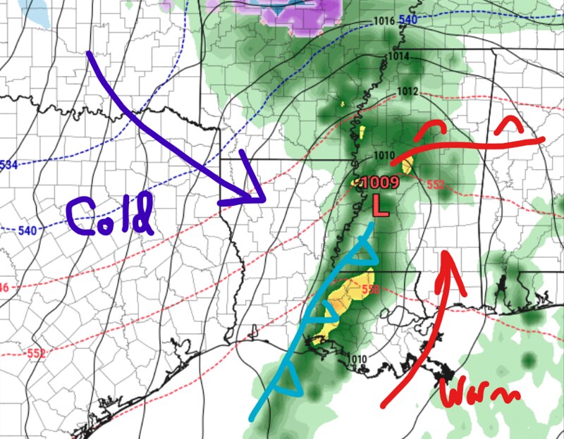
Yesterday I mentioned that it was a bit of a wildcard given the direction it was moving — the area of low pressure was developing as a cold front came in from the northwest. And that is still true. The GFS computer weather model (shown above) has that area of low pressure developing inland a bit quicker, allowing it to wrap some extra Gulf Moisture north.

This creates a scenario where the “horizontal” physics are set up to produce severe weather, but the “vertical” physics are not. Or, in fancy weather terms, we have Shear and Helicity (spinning) but we may not have instability for stronger updrafts (air that was to go up).
And any extra warmth we can pool at the surface, from say, an area of low pressure that develops a bit faster or is stronger, the better the chance is that severe weather occurs.
What are the chances that happens? Not low, that’s for sure. The CIPS Analogs shows the same Top Analog as yesterday, with a score that is up about 1 whole point. That may sound small, but we went from a “D” grade to a “C” grade in just 24 hours. And, unlike a valedictorian, a “B” grade on the CIPS Analogs is considered really, really, good.

But before you get too concerned, in order for severe weather to happen, it needs to be about 5 to 10 degrees warmer than the model guidance is showing right now. That is where all of these analogs are currently missing. No warmth, no severe weather.
If you’re thinking, ‘well what does the European model show? Isn’t that one better?”
It is showing roughly the same thing. And it isn’t necessarily better.
So, then, where is the snow? Where is the sleet? The wintry weather?

You have to wait until late Saturday night and into Sunday morning. There looks to be a brief window – a bit like last time – where some snowflakes may fall. And looking at the model guidance, it is less likely they are “true” snowflakes and more likely they are ice crystals or ice pillars. Still frozen precip falling, but not as ‘fun’ I know.
If this happens, the precip would be pretty light. And no accumulations would be expected.
Our ‘elbow’ isn’t big enough or far enough south to get any kind of ‘over-running’ scenario like in December of 2017.

But things can change a bit. If the cold air behind the front is a bit more beefy, we could squeeze out some extra snowflakes. And if the warm air is a bit more burly, we could squeeze out some extra severe weather.
So please, keep tabs on the forecast this week so you know what to expect this weekend!
Day-to-Day Forecast
Today
Partly cloudy. Highs in the upper 50s.
Tonight
Mostly clear. Lows in the mid 30s. .
Thursday
Sunny. Highs in the mid 60s.
Thursday Night
Clear. Lows in the upper 30s.
Friday
Mostly sunny. Highs in the lower 60s.
Friday Night
Partly cloudy. Lows in the lower 40s.
Saturday
Mostly cloudy with a chance for showers and storms. Highs in the lower 60s. The chance of rain 60-percent.
Saturday Night
Cloudy with a few lingering patches of drizzle possible. Very light wintry mix possible closer to I-20. No accumulations expected. Lows in the mid 30s. The chance of rain 30-percent.
Sunday
Clearing skies. Cooler. Highs around 50.
Sunday Night
Mostly clear. Lows around 30.
Martin Luther King Jr Day
Sunny, warmer. Highs in the mid 50s.
Monday Night
Mostly clear. Lows in the lower 30s.
Tuesday
Mostly sunny. Highs in the upper 50s.


