The weather should be nice today. A few passing clouds with no real threat for rain. But no one really cares about the weather for today. People care about the weather for tomorrow.
Thanksgiving is the start of a more active weather pattern for the next few days. It starts with a warm front that is set to lift north through the area during the day on Thanksgiving. This will allow for some showers and storms to develop.
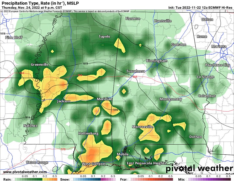
Looking at the maps below, by 3p the showers look to increase and then by the evening and into the overnight hours the showers and storms should be pretty widespread.

The good news is that storms, at this point, don’t pose a very high risk for producing severe weather. Instead, these showers and storms will feature brief heavy rain, lightning, gusty wind and small hail. The tornado threat, at this point is near zero.
Black Friday is going to be a bit of a toss-up.

Right now, model guidance shows things remaining dry through the day. But I’m not certain I buy that quite yet. I tend to think we will see a few showers here and there as well as mostly cloudy skies.
Then on Saturday the next batch of storms blow through. These will not be a long the standard cold front. And that may be good for us.

Because instead of a line of severe storms with heavy rain, lightning, wind gusts up to 70mph, hail and the potential for tornadoes.. We will see a line of storms that may pose the risk for some strong storms with brief heavy rain, lightning, some gusty wind, lea-sized hail and no big threat for tornadoes.
That said, I don’t think this is a slam dunk event. And there is definitely some wiggle room to allow some severe weather. Particularly if either (a) the backside of the storms has a cooler pool of air or (b) the air ahead of those storms is a bit warmer at the surface.

The 12z Euro model data from yesterday paints a picture with a little bit of both. And the Skew-T chart above definitely looks like a chart that can produce severe weather across the Southern MS/AL/LA region.
So while I don’t think this is a situation I’d lose sleep over. It is also not a situation I would dismiss as ‘no biggie’ either.
Instead, just keep tabs on the forecast in the coming 24-48 hours!
DAY TO DAY FORECAST
Wednesday
Sunny. Highs in the lower 70s.
Wednesday Night
Mostly clear in the evening, then becoming partly cloudy. Lows in the lower 50s.
Thanksgiving Day
Mostly cloudy storms possible in the afternoon and evening. Highs in the lower 70s. Chance of rain 80 percent.
Thursday Night
Cloudy with showers and storms possible. Lows around 60. Chance of rain 60 percent.
Friday
Mostly cloudy with scattered storms possible. Highs around 70. Chance of rain 40 percent.
Friday Night
Mostly cloudy storms possible overnight. Lows around 60. Chance of rain 60 percent.
Saturday
Mostly cloudy with a few storms possible before noon. Highs in the mid 60s. Chance of rain 60 percent.
Saturday Night
Partly cloudy with a few lingering showers and possible. Lows in the mid 40s. Chance of rain 20 percent.
Sunday
Sunny. Highs in the upper 60s.
Sunday Night
Mostly clear. Lows in the upper 40s.
Monday
Sunny. Highs in the upper 60s.
Monday Night
Mostly clear. Lows in the upper 40s.
Tuesday
Sunny. Highs around 70.


