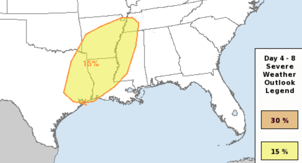
Looking ahead toward the weekend, we have another chance for showers and storms. And there continues to be an outside shot for severe weather. The Storm Prediction Center has outlined parts of our western area with a Slight Risk for severe weather. That is a “2” on the 1-to-5 scale where “5” is the highest risk for the most significant severe weather.
The interesting thing worth watching is how quikcly the risk for severe weather diminishes. The current model guidnace shows the continued risk for storms across Texas, Louisiana and Arkansas. But as the storms shift into Mississippi the mid-levels of the atmosphere may not be as favorable.
The Euro model this morning shows a few things of note.
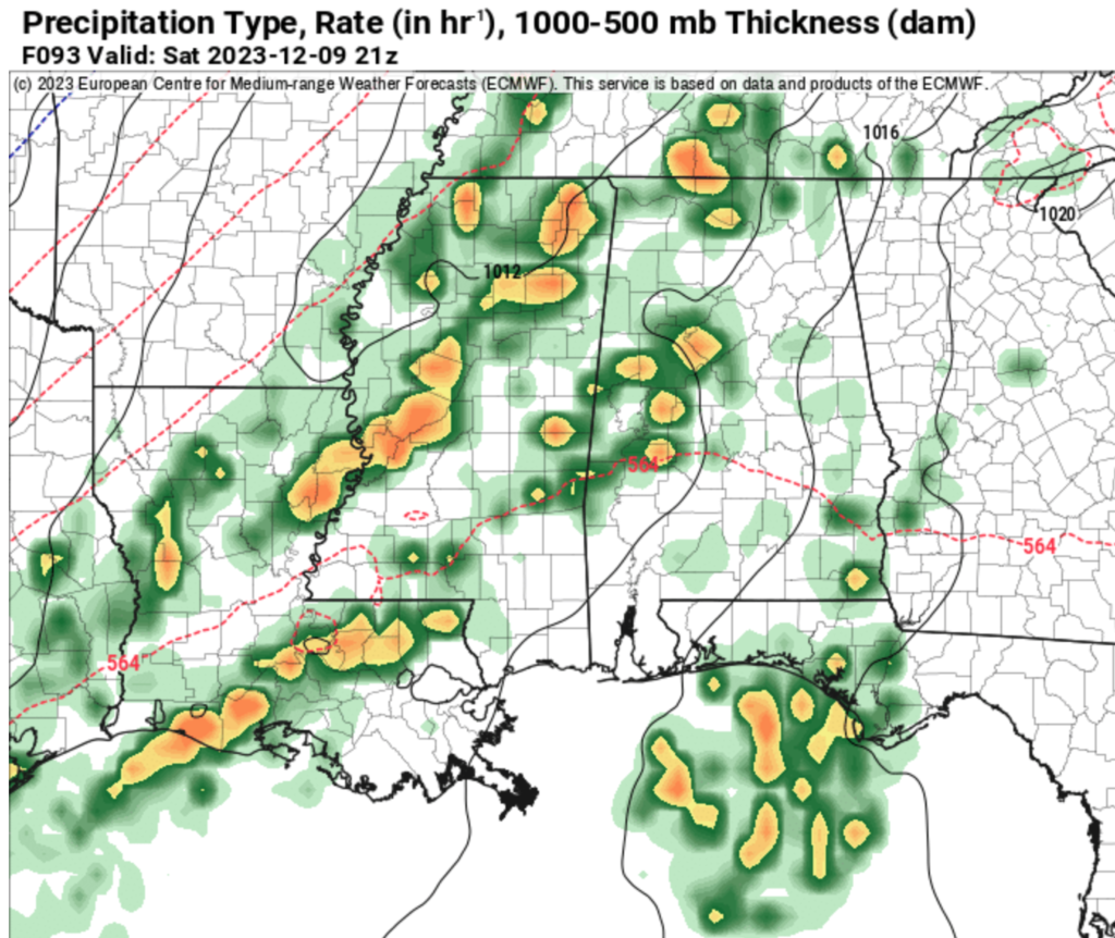
First in how clustered the storms appear in the reflectivity estimate. This is a good indicator that we have a chance for discrete storms, but also that there may not be much capping ahead of the line. While that would mean we can see discrete storms, it also means that many storms may go up at once and cluster together. And that could limit the threat for tornadoes (but hold a potential for strong wind gusts).
Second is the blob of storms shown off the Florida coast and out into the Gulf. If that blob is big enough, it would limit the low-level flow into the region and cut off the juice needed for stronger storms to develop.
Third, the mid-level atmospheric setup may have more “speed shear” and less “directional shear” which would limit the tornado risk, but hold the risk for strong wind gusts. And the speed shear may be locked up above a weak inversion that may develop as the storms traverse the area. That would limit the potential for some of the strongest winds from mixing down the surface in some of the storms that develop.
So there is still a bit to chew on and figure out as we move toward the weekend.
Once we get through the storms, things look to cool down as we move through next week. And may stay seasonably cool through all of next week and potentially next weekend, too.

[wpcode id=”41149″]
REGIONAL DAY TO DAY WEATHER FORECAST
Wednesday: Sunny. Highs in the upper 50s. North winds 5 to 10 mph with gusts up to 20 mph.
Wednesday Night: Clear. Widespread frost after midnight. Cold with lows in the lower 30s. Northeast winds around 5 mph.
Thursday: Areas of frost in the morning. Mostly sunny. Highs around 60. Southeast winds around 5 mph.
Thursday Night: Mostly cloudy. Not as cool with lows in the lower 40s. Southeast winds around 5 mph.
Friday: Partly sunny. Not as cool with highs around 70.
Friday Night: Mostly cloudy. A slight chance of showers after midnight. Not as cool. Near steady temperature in the upper 50s. Chance of rain 20 percent.
Saturday: Partly sunny. A slight chance of showers and thunderstorms in the morning, then showers likely with a chance of thunderstorms in the afternoon. Highs in the mid 70s. Chance of rain 60 percent.
Saturday Night: Showers with a chance of thunderstorms in the evening, then showers likely with a slight chance of thunderstorms after midnight. Cooler with lows in the mid 40s. Chance of rain 60 percent.
Sunday: Sunny. A slight chance of showers in the morning. Much cooler with highs in the upper 50s. Chance of rain 20 percent.
Sunday Night: Mostly clear. Cooler with lows in the mid 30s.
Monday: Mostly sunny. Highs in the lower 60s.
Monday Night: Partly cloudy in the evening, then becoming mostly cloudy. Lows in the upper 30s.
Tuesday: Partly sunny. Highs around 60.


