We are still looking at two chances for storms during the next few days. One will arrive this afternoon, mainly north of I-20 and the second will arrive Friday morning. Yes, friends! I have finally decided to jump on the Friday morning bandwagon for this next round of rain. This no longer looks like an ‘up-all-night’ kind of situation.
First things first, tonight’s chance for rain: it is low. But not zero.

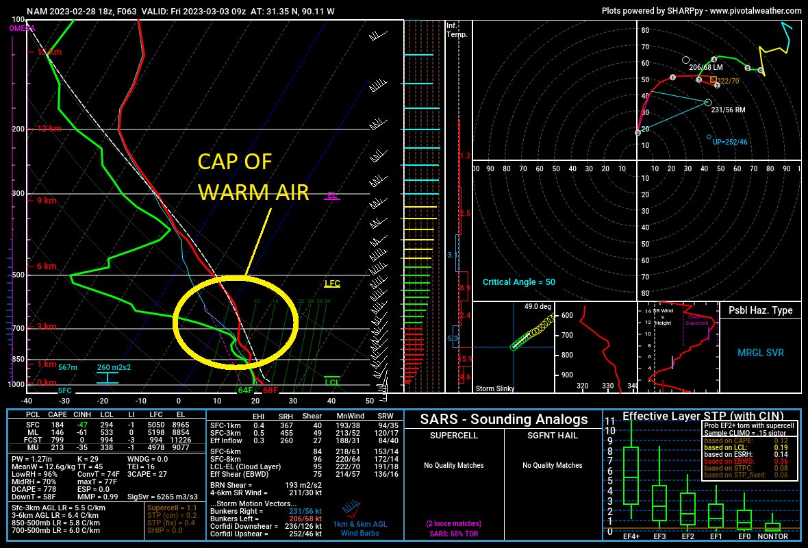
We may see a few wayward storms develop, most will be near or north of I-20. Any severe threat I think will be well-north of I-20. There will be a reasonable cap of warm air aloft and most of the forcing will also be well north.
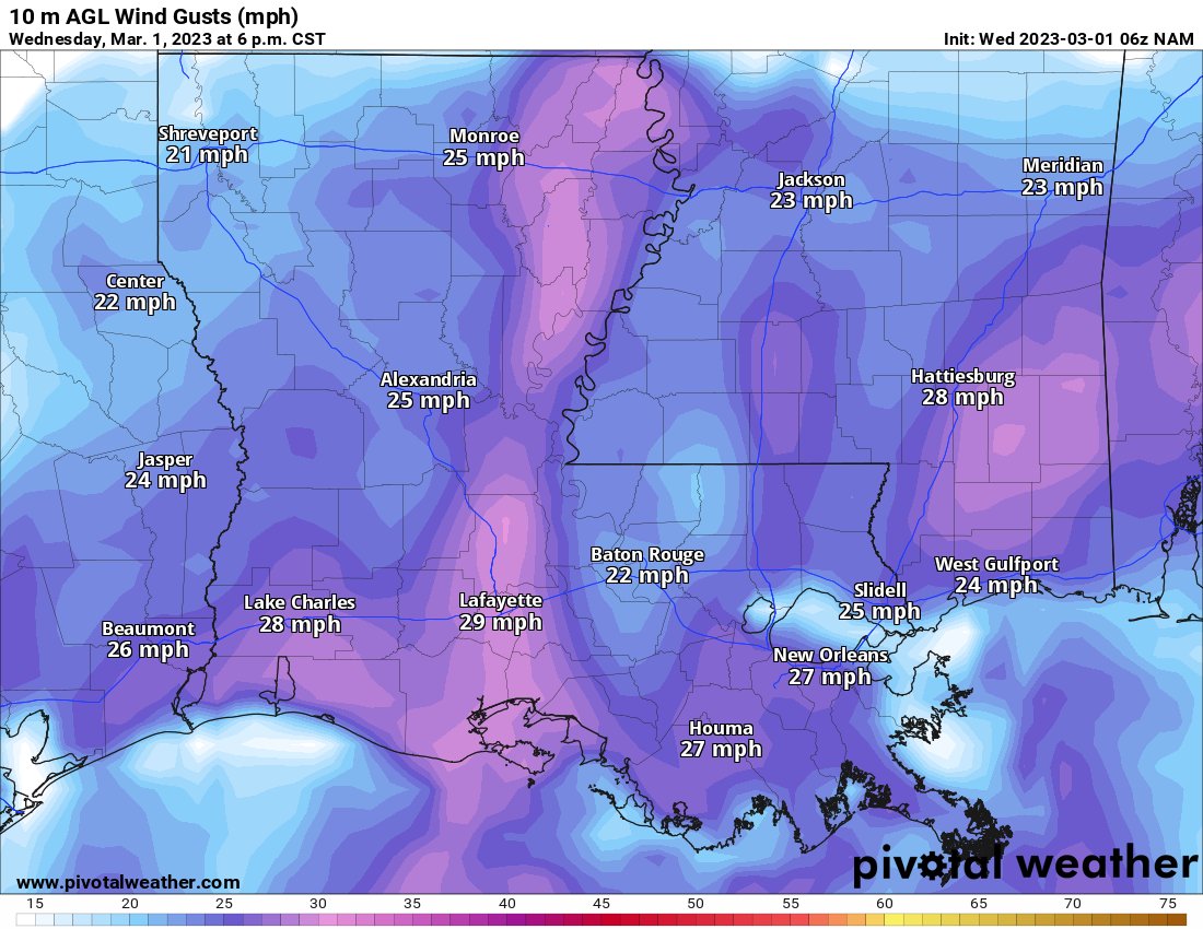
It will be breezy today and tonight, too. Model guidance showing gusts up to 30mph across the area.
For Thursday, things get more interesting. But still not too robust.

As I’ve been discussing the last few days, the risk for more significant sever weather is back to our west and northwest. The Storm Prediction Center continues to shimmy the highest risk for severe weather away from the Southern MS/AL/LA region and the central Gulf Coast. The tail end of the Enhanced Risk is now near Jackson.
I ran the Karrie Meter last night and it kicked back a 4.13. That holds this morning. The graphic below here does not have the updated timeline on it, though. More on that later

The interesting part about how high the “TOR LEAN” number is, is that I think it is giving a bad reading given how strong the shear will be. So I, for now, am going to have to dismiss it a bit.
Model guidance isn’t overly-excited about the prospects for storms down here. the morning run of the North American model (NAM) barely has a line of storms move through.
This is probably under-doing things a bit, but I tend to think we get one quick line of storms – with heavy rain, lightning and some strong wind – and then we are done. There is a chance for a few tornadoes, too, but this setup may end up like the one we had a few weeks ago where storms get over-sheared and can’t – for lack of a better descriptor – stand up straight.
Actually, come to think of it… Here is a good way to look at these storms: they’re drunk on shear. Most of them won’t be able to stand up straight and the ones that will be able to, have a pretty good shot to be pretty loud and obnoxious (very heavy rain, a lot of lightning, hail, and the chance for a tornado). And if you aren’t paying attention, these things can roll through and really mess up your yard and patio furniture.
The good news is that the cap of warm air aloft will help to keep any storms ahead of the line in check. Could we see one or two storms try to develop? Sure. But they’ll be really hard pressed to get moving.

And all of the forcing in the low levels is the reason I tend to think we will have a line of storms develop, despite what the model guidance shows on the animation above.
Notice the timeline on the animation above, too. This is looking more and more like a Friday morning event. So, I’ve update the Storm Timeline to reflect that.
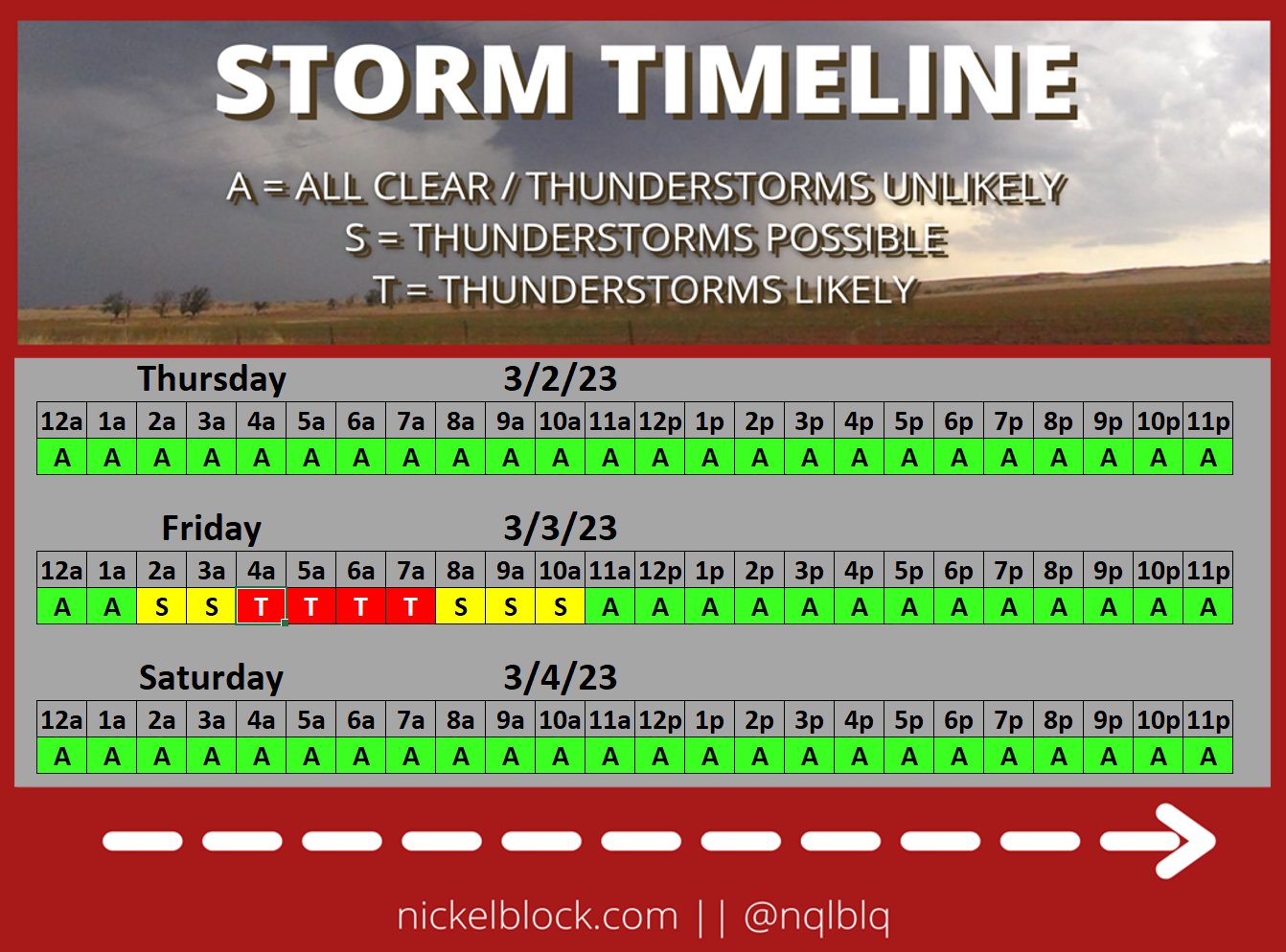
This is why I kept saying, “don’t cancel those Thursday plans!” because I had a feeling this would slide into Friday.
I will note that it is going to be windy even if you don’t see storms. Thursday night and into Friday morning wind gusts will be up around 40-50mph at times. So I’d make sure you don’t leave any patio umbrellas up, or your neighbors may inherit it – and a broken window.


Once we clear this out, we have a great looking weekend in store!
REGIONAL DAY-TO-DAY FORECAST
Today
Cloudy this morning, then becoming partly sunny. Patchy fog this morning. Highs in the mid 80s. South winds 10 to 15 mph with gusts up to 25 mph.
Tonight
Mostly cloudy. A slight chance of showers after midnight. Lows in the upper 60s. South winds 10 to 15 mph with gusts up to 25 mph. Chance of rain 20 percent.
Thursday
Mostly cloudy in the morning, then becoming partly sunny. A slight chance of showers. A slight chance of thunderstorms in the afternoon. Highs in the lower 80s. South winds 10 to 15 mph with gusts up to 25 mph. Chance of rain 20 percent.
Thursday Night
Mostly cloudy. Storms possible well after midnight. Some severe. Lows in the mid 60s. South winds 15 to 20 mph. Gusts up to 30 mph, increasing to 40 mph after midnight. Chance of rain 60 percent.
Friday
Storms possible between 3a and 9a then partly sunny. Less humid with highs in the mid 70s. Southwest winds 15 to 20 mph with gusts up to 40 mph. Chance of rain 20 percent.
Friday Night
Clear. Much cooler with lows in the upper 40s.
Saturday
Sunny. Highs in the lower 70s.
Saturday Night
Clear. Lows in the upper 40s.
Sunday
Sunny. Highs in the mid 70s.
Sunday Night
Mostly clear. Lows in the upper 40s.
Monday
Mostly sunny. Highs around 80.
Monday Night
Partly cloudy in the evening, then becoming mostly cloudy. Lows in the upper 50s.
Tuesday
Partly sunny with a 20 percent chance of showers. Highs in the lower 80s.


“Drunk on shear” is one of the best explanations I’ve heard – thank you and YOINK!