Happy Wednesday everyone! Today’s CONUS weather forecast will be a look at the major weather features in each part of the country over the next seven days, with a more general long-range outlook at the end. As usual, we will begin with a look at the general synoptic pattern of the whole CONUS, and then dive into each region one by one.
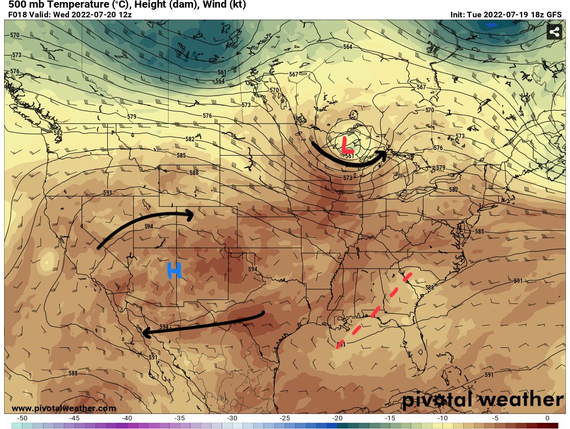
Looking at the upper-level flow, we can see a strong upper-level ridge centered over Arizona and New Mexico providing extreme heat and high temperatures across much of the south and southeast. In addition, a strong upper-level low is moving across the Canadian boarder near Wisconsin and Michigan bringing severe weather potential. Finally, marked with the red dashed lines is a weak trough moving through the southeast.
Western Part of CONUS
Looking at the western part of the CONUS, both ensemble models suggest for higher than normal heights to continue for much of next week.


Given the higher heights in the atmosphere, one would expect higher than average temperatures to remain down at the surface. This is due to hot air “expanding”, leading to the higher heights in the atmosphere. We can confirm this by looking at the surface temperature anomalies over the next week.


Our results are confirmed, with both ensemble models showing plenty of red in the west, indicating temperatures 4-10 degrees above average over the next week. As we saw in the beginning, the ridge over this part of the country is centered right over New Mexico and Arizona, which is why the entire western CONUS is expected to see higher than average temperatures.
This leads us to precipitation, which is very limited over the west, besides portions of Arizona and New Mexico expected to receive some rain this week.


Central / Southern CONUS
Looking the central CONUS, compared to the western CONUS the chances for more severe weather is higher, with hot temperatures continuing to be the theme as well.
Firstly, the SPC has a slight risk of severe storm activity highlighted over portions of Ohio, Indiana, Michigan, and Kentucky for the day today.

If you think back to the first image pointing out the upper-level low moving through this region, that would be the synoptic driver for this better chance at more severe weather.

This upper-level low is expected to coincide with a surface-low pressure system that will bring along a cold front boundary. The combination of positive vorticity advection, meaning higher vorticity or “spin” being moved into the region, along with day-time heating and forcing from the cold front means thunderstorms and some severe weather are expected.
Taking a look at a sounding over the Ohio region, we can see why severe weather is likely to be experienced across the region.

There is a lot of information on soundings, but if we just focus on the circled and marked values, we can see the ML or mixed layer CAPE being at 1732 J/KG, which is sufficient for severe weather development in the summertime. The shear values are below 40kts, with above 40kts being favorable but still enough the see a threat for a tornado as highlighted in the possible hazard type and noted by the SPC. We can also see a very low LCL (lifted condensation level) and LFC (level of free convection), meaning once parcels reach this level, which is quite low at around 860MB, they will build and develop until they reach the EL (equilibrium level) up near 150MB.
Looking at the rest of the region, this comes as no surprise that above average temperatures are expected in this part of the CONUS as well, with both the European and American ensembles picking up on this pattern.


There is very little blue or below average temperatures on this map, with portions of North Dakota expected to receive some below average temperatures.
Looking at the precipitation, totals are highest where the severe weather threat is expected today across the Great Lakes region.

Northeast CONUS
Looking at the northeast, rain chances are pretty limited, with the story being the heat over the next week with temperatures and humidity expected to remain elevated.


Once again, both ensembles agree with the chance at higher than normal temperatures for all of the northeast, with some deeper reds indicating temperatures closer to 10 degrees above average! Just like the rest of the country, the northeast will not be spared from the heat.
There is also a chance for some severe weather in the northeast, with the SPC highlighting a slight risk over New England on Thursday.

The main risks associated with these cluster of storms will be damaging winds and hail, with a tornado possible if enough shear materializes in the area.
Besides this risk, the northeast is expected to remain mainly dry with very low 7-day precipitation values expected along the northeast and increasing towards the Great Lakes region.

Long Range Outlook
Taking a look at the longer range 8-14day temperature and precipitation outlook from the CPC, we can get a glimpse on the expected pattern over the CONUS.

With the main color on this map being red, it is clear that much of if not all of the CONUS is expected to receive above average temperatures, with localized higher chances in the Pacific Northeast and the southeast into the northeast.
Looking at precipitation, there are pockets of higher than normal amounts expected near the Great Lakes and for portions of the southwest. Much of the rest of the country is not expected to receive and more or less than average amounts of precipitation.


