A couple of attempts at tropical cyclone genesis for the Atlantic Hurricane Season have occurred this past week with invests 97L & 98L but have not come to fruition and the lull in activity continues, but don’t let your guard down, as the peak of Hurricane Season has yet to arrive.
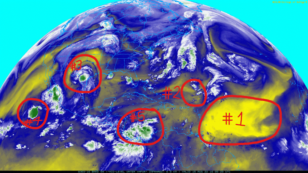
1) The Saharan Air Layer (SAL) continues to cover most of the Main Development Region (MDR) and is one of the main reasons why Invest 97L did not develop any further as it moved through the Atlantic Ocean.
2) The remnants of Invest 97L has caused some showers and cloudiness as its weak area of low pressure slowly moves through the Atlantic, but is experiencing very hostile conditions including strong wind shear and dry air and is not expected to develop any further.
3) The remnants of Invest 98L continue to bring heavy rains and cooler temperatures to Southern Texas. This system continues to impress, with a defined low-level circulation on radar and clockwise upper-level divergence apparent on satellite indicating that the storm is still relatively organized despite being over land for over a day now. If 98L had only half a day more over the Gulf before making landfall it would have likely strengthened to a tropical storm.
4) Tropical Depression 10E is drifting very slowly (westward at 1 mph) over sufficiently warm waters to allow for convective bursts, but further development and organization is not expected at this time.
5) A weak tropical wave will make its way northwestward into the Bay of Campeche and has a 20% chance of tropical development within the next 5 days.
Brief Atlantic Hurricane Climatology Discussion
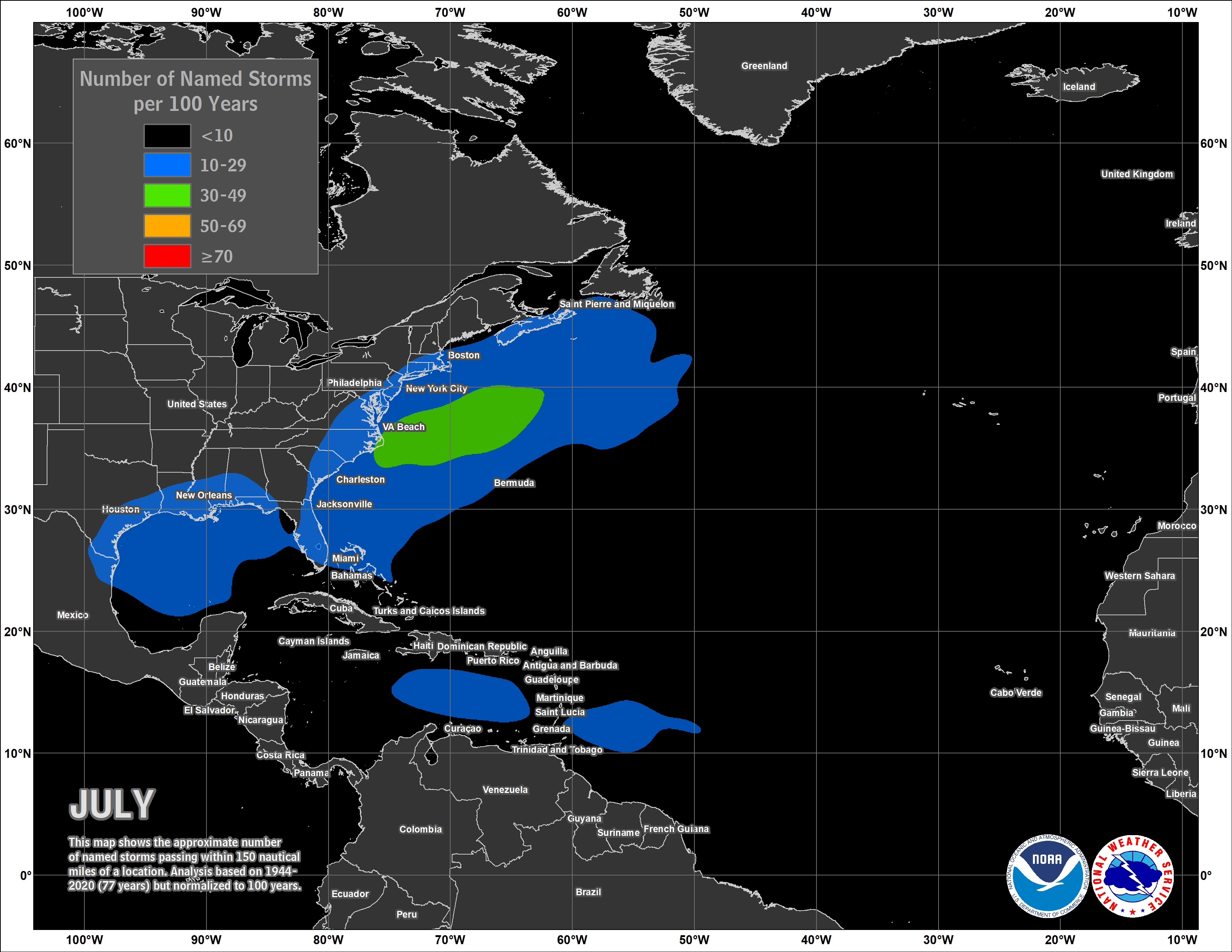
To get an idea of the climatological difference in tropical activity between the early stages of hurricane season and the peak, take a look at the above image. This is the approximate number of named storms that occur in the month of July, i.e., the average number of storms you would see with 150 nautical miles over a 100 year timespan.
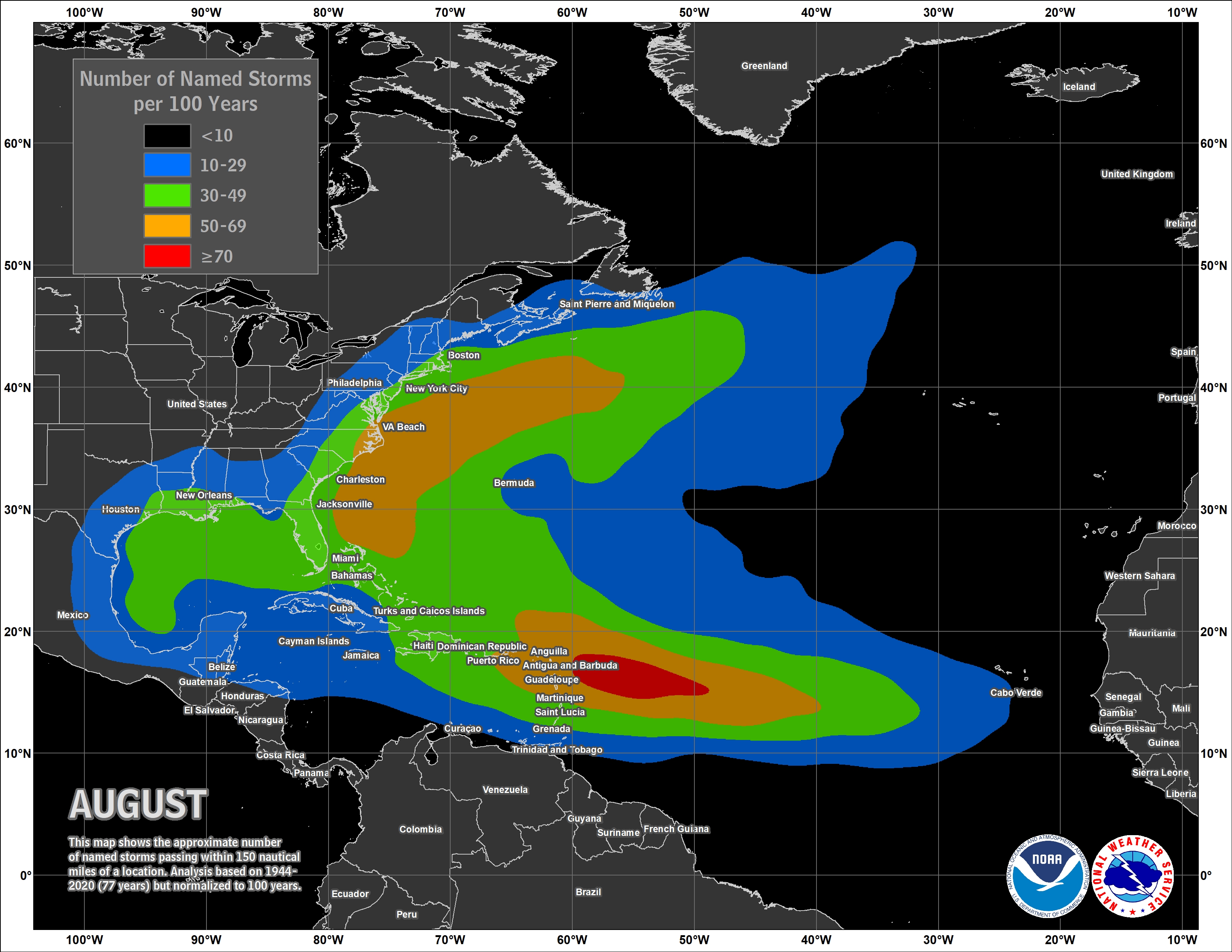
As ocean temperatures tend to increase, shear decreases, and the number tropical waves coming off the coast of Africa increases (also known as African Easterly Waves, AEWs, which account for the majority of tropical systems in the Atlantic) the number of named storms has a large jump in the month of August.
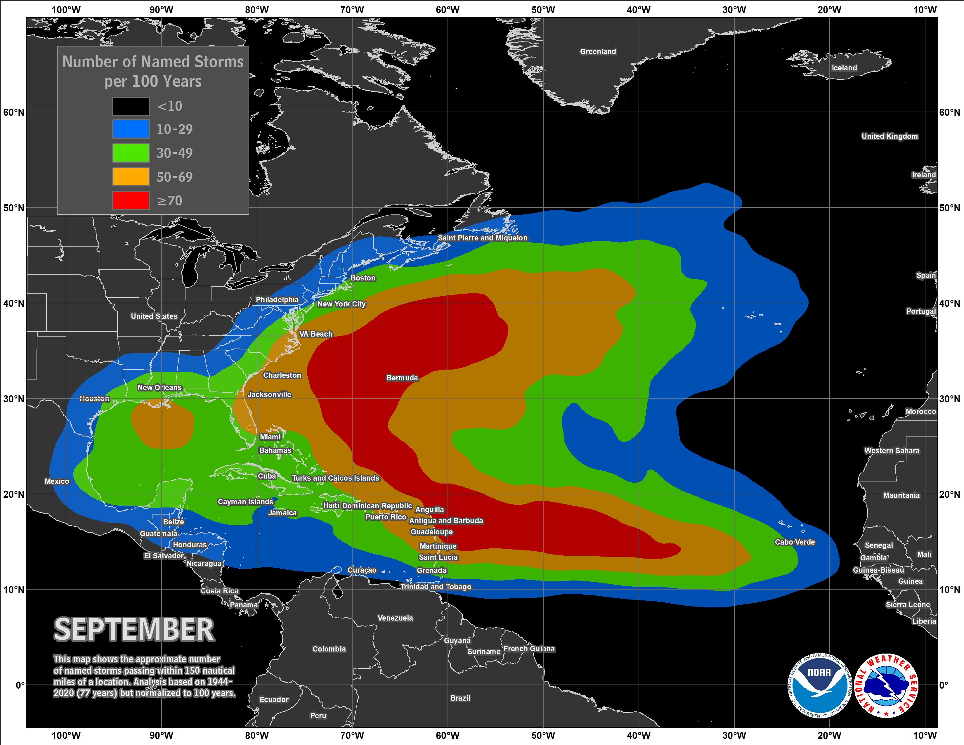
September is climatologically the most favorable month for tropical activity and the number of hurricanes that impact the U.S., and has been the month occupied by major hurricanes like Irma (2017), Maria (2017), and Dorian (2019).
Fortunately, most of August looks to be quiet in terms of tropical activity; however, there are some signs that the very end of August will feature activity in the MDR as thunderstorm activity near the equator over the continent of Africa increases and the number of AEWs entering the Atlantic increases. This is to be expected when the peak of the season nears and atmospheric conditions become more favorable. Some global model guidance runs and ensembles agree that activity will begin to pick up soon, but it’s best not to get caught up in the individual model runs showing major hurricanes in the long-range you might see on social media.
Atlantic Ocean Surface Temperature Analysis
Besides dry air and wind shear, the surface temperatures of the ocean can play a huge role in the development of tropical storms, so let’s see what future tropical waves will have to work with in the MDR:
Most AEWs leave the coast of Africa just north of the 10N line and head westward slowly gaining latitude depending on the steering winds aloft. Most of the Sea Surface Temperatures (SSTs) through the MDR are conductive of tropical development (at or above 26C) and will provide fuel for any storms that traverse through the region; however, cooler SSTs have made their way southward around the 40W, 20N line just enough that they could prevent cyclone genesis, or at least slow down the process if any tropical system gains enough latitude to move over these cooler waters.
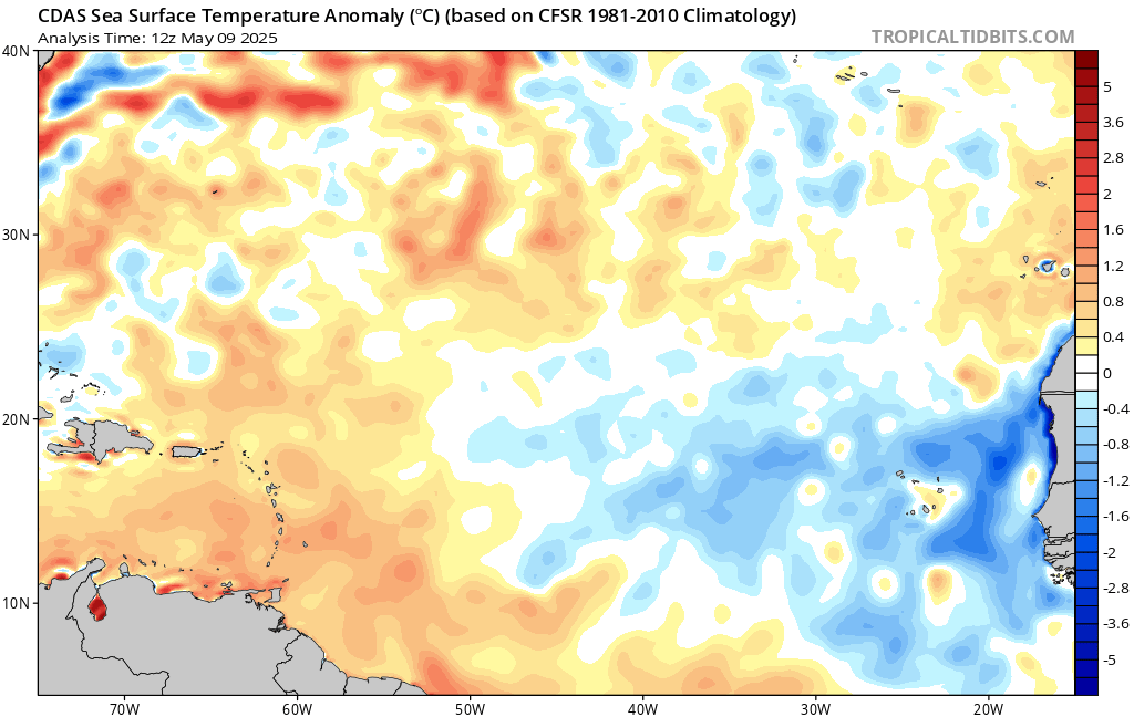
That pocket of cooler waters around the 40W, 20N area is anonymously cool for that part of the Atlantic and will likely make an impact on the season as a whole if it remains that way. Otherwise the MDR’s surface ocean temperatures are about average at the moment and are still conductive of tropical development.
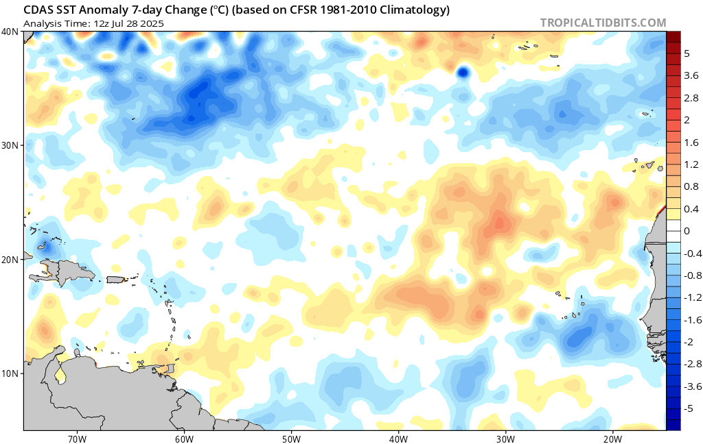
Over the last 7 days several pockets of surface warming have occured between the 10N and 20N lines, most notably east and north of the Virgin Islands and west of the Cabo Verde Islands which will provide more energy to tropical systems.
Regardless of what’s expected to happen, it’s a good idea to always have a hurricane safety plan, including determining your risk if a tropical system were to impact you based on where you live, an evacuation plan, and assembling disaster supplies. More information can be found at https://www.noaa.gov/hurricane-prep


