
Tropical Storm Isaias took a while to finally form, but it is now cruising right along and through parts of Hispaniola. You can see the brighter colors, indicating the more robust convection, blossoming nearer to the center today than previous days. Reports of power outages, trees down, and minor damage have been reported – already – across parts of Puerto Rico and Haiti via Twitter.
The Tropical Storm may even make a run at becoming a hurricane before getting to the Bahamas, depending on how atmospheric conditions shake out and how quickly the low-level, mid-level and upper-level center can align.
On the visible satellite imagery, you can see that the storm is starting to lok much better organized today than previously, too, despite thecurrent interaction with land.
Courtesy: College of DuPage Meteorology via GIPHY
From the NHC
SUMMARY OF 1100 AM AST…1500 UTC…INFORMATION
LOCATION…18.1N 68.9W
ABOUT 50 MI…75 KM SW OF PUNTA CANA DOMINICAN REPUBLIC
ABOUT 165 MI…265 KM SE OF PUERTO PLATA DOMINICAN REPUBLIC
MAXIMUM SUSTAINED WINDS…60 MPH…95 KM/H
PRESENT MOVEMENT…NW OR 310 DEGREES AT 20 MPH…31 KM/H
MINIMUM CENTRAL PRESSURE…1003 MB…29.62 INCHES
DISCUSSION
The satellite presentation of Isaias has improved over the past 24 hours with a concentrated area of deep convection occurring near and to the northeast of the low-level center. Radar imagery from Puerto Rico has shown a mid-level circulation that moved over the Mona passage and is now along the northern coast of Hispaniola. Surface observations and data from an Air Force Reserve reconnaissance aircraft, however, continue to place the center near the southeastern coast of Hispaniola. It is possible that a new center will re-form along the northern coast of Hispaniola as the system interacts with high terrain of that island later today or tonight. The initial intensity remains 50 kt, and is based on the earlier Doppler radar data and observations along the southern coast of Puerto Rico.

Isaias is moving northwestward or 310/16 kt. A high pressure ridge over the western Atlantic should steer Isaias on a west-northwestward to northwestward heading over the next couple of days, but the likelihood of a center re-formation during the next 12-18 hours means that some adjustments to the track and motion are possible. By late Friday, a mid-latitude trough moving into the east-central United States is expected to weaken the western portion of the ridge. This pattern should cause the cyclone to turn northwestward to north-northwestward on Saturday when it is near the northwestern Bahamas and South Florida. As the trough slides eastward over the United States, this should steer Isaias northward and northeastward early next week. Although the bulk of the track guidance agrees on this overall scenario, the confidence in the track forecast remains lower than usual due to the expected land interaction and possible center reformation in the short term. The new NHC track forecast is a blend of the HFIP corrected consensus and the TCVA multi-model consensus, and is similar to the previous advisory.
The intensity forecast remains challenging. The structure of the storm is likely to be disrupted by its passage near or over Hispaniola today, and some weakening is likely. Once the system moves away from the Greater Antilles gradual strengthening is anticipated. The global models and the SHIPS guidance suggest that Isaias will encounter an area of moderate southwesterly shear over the weekend, and the NHC intensity forecast is again leveled off at that time. There are models that continue to suggest Isaias could become a hurricane when it is near the U.S., but given the continued uncertainty, the NHC intensity forecast remains near the intensity consensus.
KEY MESSAGES
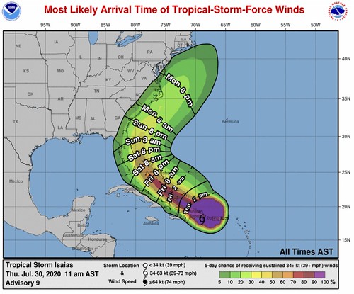
1. Isaias will produce heavy rains and potentially life-threatening flash flooding and mudslides across Puerto Rico, the Dominican Republic, northern Haiti, the Turks and Caicos, and the Bahamas. Heavy rains associated with Isaias may begin to affect South Florida Saturday morning, potentially resulting in isolated flash and urban flooding.
2. Tropical storm conditions will continue across portions of the Virgin Islands and Puerto Rico through early afternoon and will spread across portions of the Dominican Republic, Haiti, the Turks and Caicos and the Bahamas later today through Friday, and Tropical Storm Warnings are in effect for these areas. Do not focus on the details of the track forecast, as rainfall and wind hazards will extend far from the center of the system.
3. There is a risk of impacts from winds, heavy rainfall, and storm surge along portions of the U.S. east coast beginning this weekend in Florida and spreading northward to the Carolinas and southern mid-Atlantic states early next week. Due to Isaias interacting with Hispaniola, the details of the track and intensity forecast remain uncertain and it is too soon to determine the magnitude and location of these potential impacts. Interests in these areas should monitor the progress of Isaias and updates to the forecast. Tropical storm
or hurricane watches could be issued for portions of South Florida later today.
FORECAST POSITIONS AND MAX WINDS
INIT 30/1500Z 18.1N 68.9W 50 KT 60 MPH
12H 31/0000Z 19.7N 71.4W 45 KT 50 MPH…INLAND
24H 31/1200Z 21.4N 74.2W 50 KT 60 MPH…OVER WATER
36H 01/0000Z 23.0N 76.5W 55 KT 65 MPH
48H 01/1200Z 24.6N 78.2W 60 KT 70 MPH
60H 02/0000Z 26.2N 79.4W 60 KT 70 MPH
72H 02/1200Z 28.0N 79.9W 60 KT 70 MPH
96H 03/1200Z 31.5N 79.1W 60 KT 70 MPH
120H 04/1200Z 37.5N 73.5W 60 KT 70 MPH
Model Data
Now that the computer models have a “center” to latch onto for making predictions, many have come into much better agreement. While there is still some discrepancy as to the westward push as Isaias approaches Florida, the general trend is for the storm to reach Florida and turn north and then northeast around a ridge of high pressure in the Atlantic.

The European Ensembles continue to show a few members that put Isaias into the Gulf of Mexico, but a majority take it either up the spine of the peninsula of Florida or keep it out to sea.
The GFS Ensembles show a better chance that Isaias stays just off-shore of Florida as it passes by to the east and moves north up the East Coast.

Even the spaghettis show a pretty similar track.
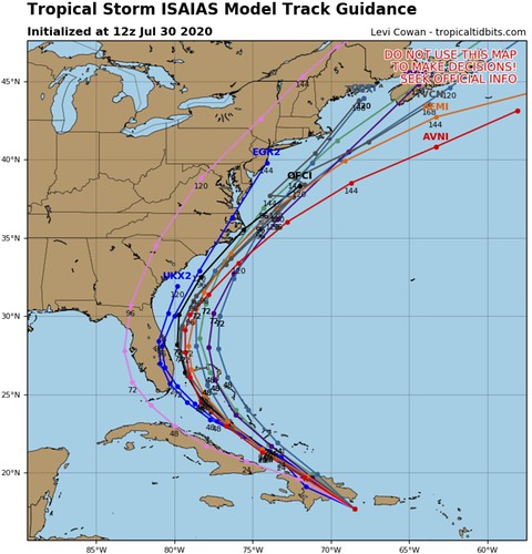
The intensity models, while not in complete consensus, are showing a trend of Tropical Storm strength.

And as of now, the model guidance for Rapid Intensification from the SHIPS model seems reasonably tempered with a 10- to 20- percent chance any form of Rapid Intensification occurrs during the next 72 hours.

That said, as I mentioned above, I wouldn’t be surprised if this makes a run at being a Category 1 Hurricane. A similar situation occurred with Hanna. And that storm was able to squeeze out an extra 5-to-10mph to be designated a Hurricane.
The Bottom Line
As this storm emerges north of the Islands of the Caribbean it will ride west-northwest toward Florida and the Bahamas and then, given the latest model data, curl north. Right now this is of no immediate threat to anyone living along the northern Gulf Coast. However, like always during hurricane season, it is important to keep track of this system until it is north of your latitude.


