As we end June and go into July, the areas that we look towards for tropical development begin to expand. In addition to the Gulf of Mexico and off the coast of the Carolinas, tropical cyclones can start their lifecycles more eastward in the Atlantic Basin as the sea surface temperatures increase even more-so.
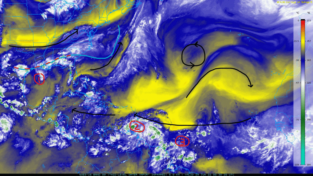
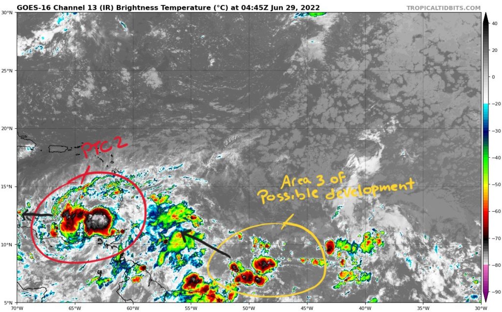
The image above shows three areas that the National Hurricane Center (NHC) is watching for development. Lets go through each of these areas:
1.) Gulf of Mexico disturbance (Invest 95L
A stationary front draped across the Southeastern states near the Gulf Coast is providing some convection in the area and may allow for some spin up for the area of interest off the Louisiana Coast. The front is also helping to provide some moisture to the region to aid in any development. This area of low pressure should move southwestward before turning back north. Model guidance supports this movement. The NHC is giving this invest a 40-percent chance of development over the next 48 hours and 5 days.

The time frame for 95L seems to be on Thursday for it to move onshore. However, rain is likely to move in earlier possibly starting late on Wednesday. This system is not expected to be a strong storm. The model consensus keeps it below tropical storm status and as a tropical depression with winds less than 35kts (40mph).

What will be the main story for this system is the rain. Even if the storm gets a name, Bonnie or Colin depending on when/if PTC 2 gets named, the disorganized nature of the convection will allow for high rain totals in the Coastal Texas area. Some parts could see rainfall totals through Saturday in the 4″-6″ range. Keep in mind that rainfall estimates are highly dependent on the exact track of 95L. Keep up to date with the local forecast office.
2.) Potential Tropical Cyclone Two (PTC 2)
Formerly invest 94L, PTC 2 was classified Monday evening and began getting advisories issued from the NHC. The potential tropical cyclone classification was first introduced during the 2017 hurricane season. It describes an area of invest that is not yet a tropical depression, but is expected to become a cyclone and bring a threat of tropical storm or hurricane conditions to areas of land in a 48-hour time period. This allows for the NHC to issue tropical storm or hurricane watches or warnings for an unnamed storm. Currently, the NHC gives PTC 2 a 80-percent chance of development over the next 48 hours and a 90-percent chance for the next 5 days.
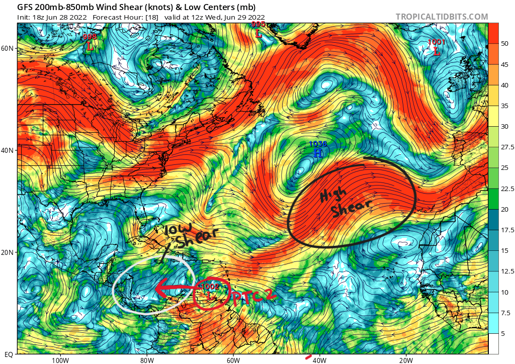
To aid in the development of PTC 2 is the fact that it is heading westward towards an environment in the south Caribbean with low wind shear. Wind shear is how the wind changes speed and direction between two layers of the atmosphere. Areas of high shear (large change in wind between the two layers) are not conducive for tropical cyclones as they tend to tilt the storm and basically tear them apart. Cyclones want to be vertically aligned.

Model guidance above shows a gradual strengthening as PTC 2 moves away from South America into the Caribbean. The environment it is moving towards also has sea surface temperatures above 80F and water above 26C (78F) extending past 100m (328ft) in depth. High sea temperatures and larger depth of warm water is another crucial component for tropical cyclone development. Models and the NHC have PTC 2 becoming a brief category 1 hurricane shortly before landfall in Nicaragua.
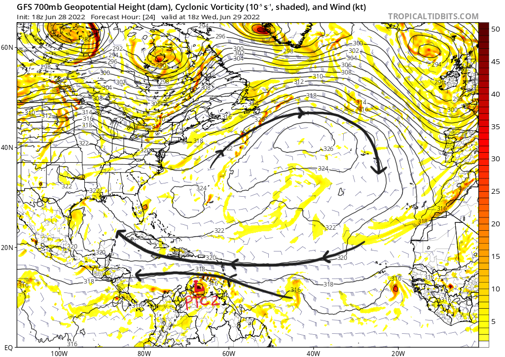
Models keep PTC 2 more toward the south in its track hugging the South American coastline as it moves westward. A mid-level ridge will prevent PTC 2 in a more northward trajectory avoiding the continental U.S. This thinking is mirrored in the official NHC forecast making landfall as a possible category 1 hurricane in Nicaragua on Friday.

3.) Central Atlantic Disturbance
The last area of interest is currently a disorganized cluster of thunderstorms behind PTC 2. A moist environment left behind PTC 2 could help this system develop gradually as it moves west-northwestward. For now, the NHC is giving it a 10-percent chance of development in the next 48 hours and a 30-percent chance over the next 5 days.
As of now, there are no serious threats to the continental U.S. with the exception of heavy rainfall expected for Coastal Texas and the surrounding areas. For more information, visit hurricanes.gov for up to date information.


