Good morning, folks, and happy Hump Day! Today for the Tropical Outlook, we’ll examine what the National Hurricane Center is currently watching, take a look at the weather across the Tropics, and we’ll observe model data to get an idea of how the weather in the tropics will evolve in the coming days.
From the National Hurricane Center
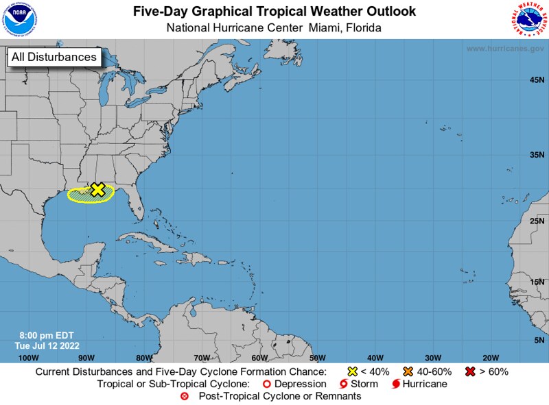
In the Atlantic Basin, the National Hurricane Center is still watching a disturbance in the Northern Gulf of Mexico with a measly 10-percent chance to develop into a tropical cyclone in the next few days. While this system likely won’t develop into a Tropical Storm before it moves onshore later this week, it will continue to be responsible for some heavy rains along the Gulf Coast.
The more exciting although less-important weather is in the Eastern Pacific Basin, where the NHC is watching two systems: Hurricane Darby and an undesignated area of interest.

On Monday, Hurricane Darby strengthened to a category-four hurricane, with winds as strong as 140mph, and a minimum central pressure of 954mb! Since then, it has weakened to a category-two storm and will continue to weaken as it moves into an unfavorable environment.
For the disturbance south of Central America, the National Hurricane Center is giving it a 90-percent chance of development in the next five days. However, much like Darby before it, this system likely won’t pose much of a threat to land.
Current Tropical Picture
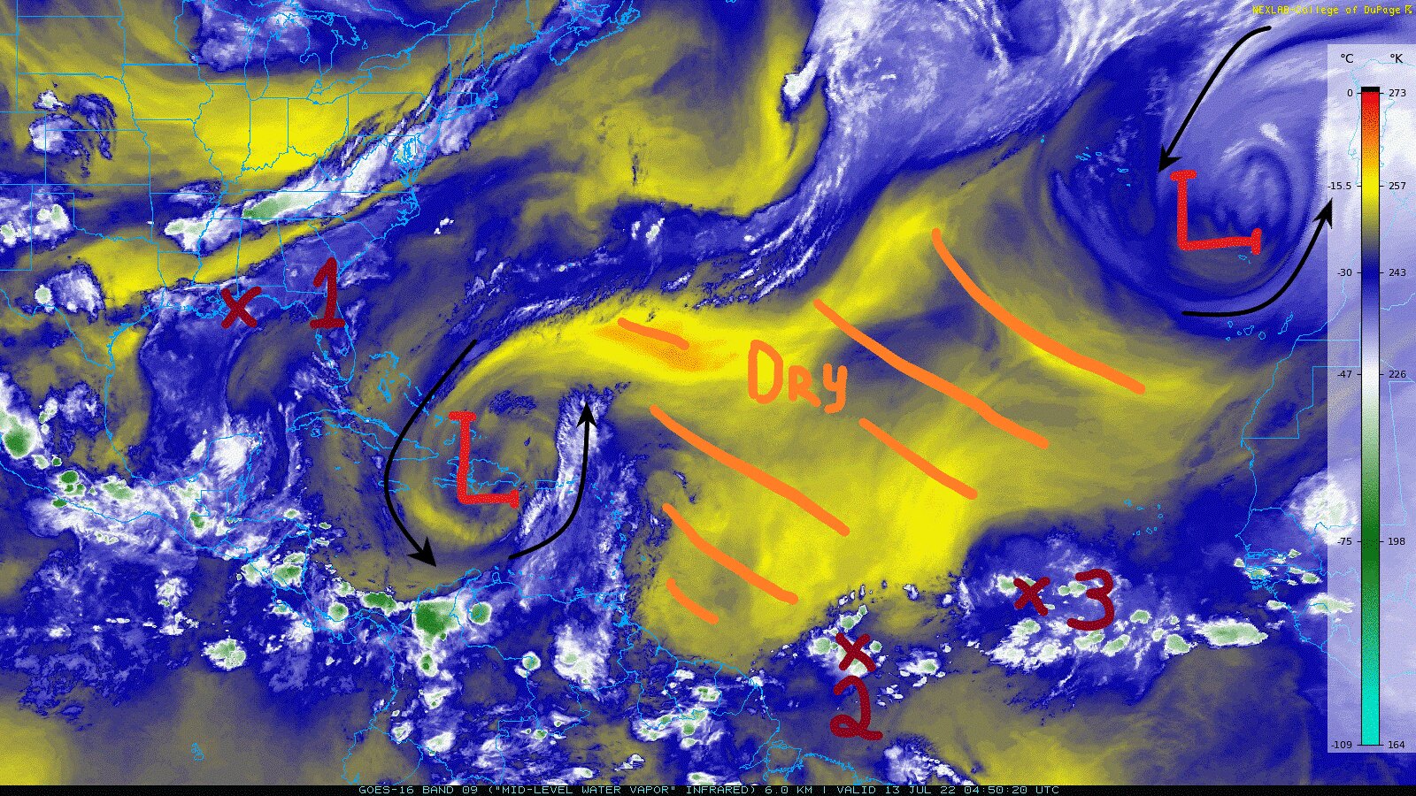
If we take a look at the mid-level water vapor imagery above, we can get a pretty good idea of the dominant features in the Tropical Atlantic. At the moment, there are two big “swirls” in the Atlantic, an upper-level low over Hispaniola and an upper-level low west of Morocco. Between the two is a very large dry air mass, as shown by the yellow and orange colors on the water vapor imagery. To the south of this air mass exists the Intertropical Convergence Zone (ITCZ), where two of our three highlighted disturbances are. These disturbances, numbered 2 and 3 above, are associated with some areas of deeper convection embedded in the ITCZ. The other disturbance, numbered 1 above, is the system that the NHC is watching in the northern Gulf of Mexico.
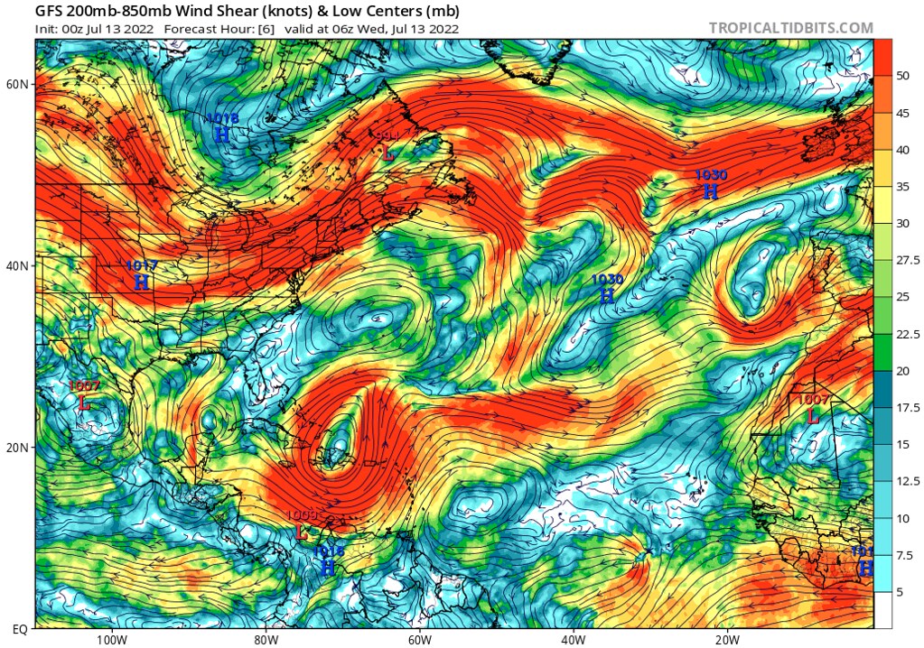
Given the two dominant upper-level lows identified from the mid-level water vapor imagery above, most of the Atlantic is full of shear. This is particularly for the Caribbean, where the close proximity between the upper-level low and the Mid-Atlantic ridge is enhancing the wind shear across much of the Tropical Atlantic.
As for where the shear is weak, the region along and to the north of the ITCZ sticks out – this looks like a more favorable environment for Systems 2 and 3. As for System 1 in the northern Gulf of Mexico, the wind shear isn’t too strong, with an average around 20 knots from the north northeast, but it will certainly not help in the system’s development.
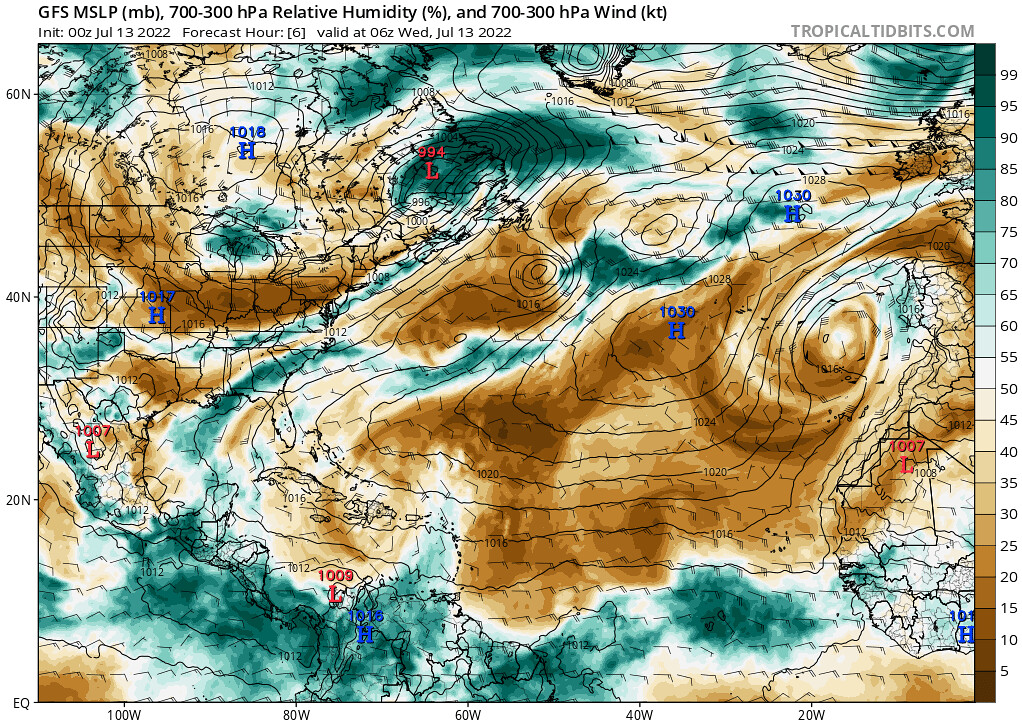
Looking at the mid- and upper-level relative humidity – we can see a similar story to what is shown in the mid-level water vapor imagery. The only notable pockets of moisture in the Tropical Atlantic are those associated with the disturbances along the ITCZ, and and narrow region of locally-higher moisture associated with the disturbance just offshore the Gulf Coast.
Just from this analysis alone we can already get a good idea of the chances that these disturbances have to develop into tropical cyclones. For System 1 in the Gulf of Mexico, the moderate shear and lack of any deep convection at the moment, as well as its limited time above the warm waters will really seem to hinder the development of this system. For System 2, the westernmost system along the ITCZ, even though it is located in a relatively weakly-sheared environment, its proximity to drier air and overall lack of sufficient moisture won’t help this system develop in the near-term. Finally, for System 3, much the same can be said, however it does have slightly better odds as its locally greater moisture plume will help to keep the drier air at bay for longer.
Model Prognosis – Gulf of Mexico
As System 1 is closer to home, let’s start by evaluating the likely evolution of this system. Regardless of whether or not this system develops into a tropical cyclone, it will still be a prolific rain-maker for locations along the Gulf Coast.

By this morning, the developing center of circulation will have already moved onshore, as shown by the region of enhanced 850mb vorticity over the Florida Panhandle above. As tropical cyclogenesis requires storms to be over the water, at this point, it is very unlikely that this system will develop. Nonetheless, it is important to note that the enhanced vorticity is not just confined to the Florida Panhandle, instead the energy for this system is still very elongated, stretching from South Carolina, through Georgia and into southern Alabama, the Florida Panhandle, southern Mississippi, southeastern Louisiana and out to the middle of the Gulf of Mexico. So, even as the potential for this system to develop into a tropical disturbance approaches 0-percent, the threat for the ongoing heavy rain to continue still exists throughout most of the day today.
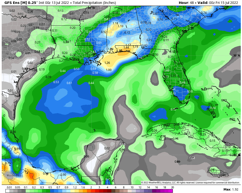
The American Ensemble model solutions show the chance for some places, particularly around the Florida Panhandle to pick up more than an inch of rain through tomorrow evening.
Model Prognosis – Tropical Atlantic
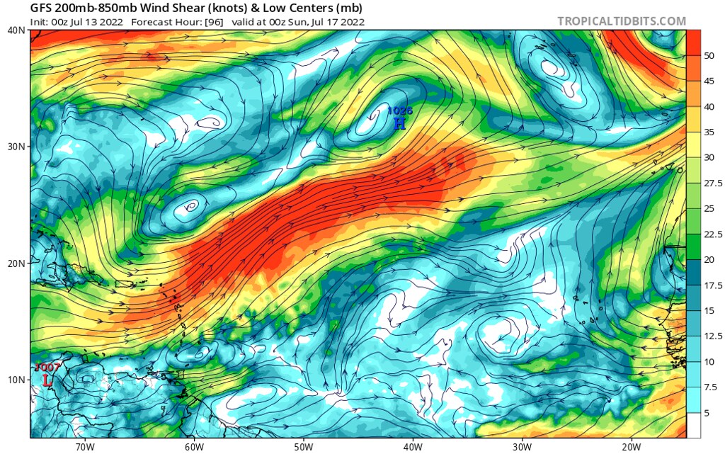
As for the systems in the Tropical Atlantic, the upper-level low responsible for strong wind shear across much of the Caribbean will move out of the region rather quickly by Friday morning, before another, weaker upper-level low moves back into the same region by Saturday afternoon.

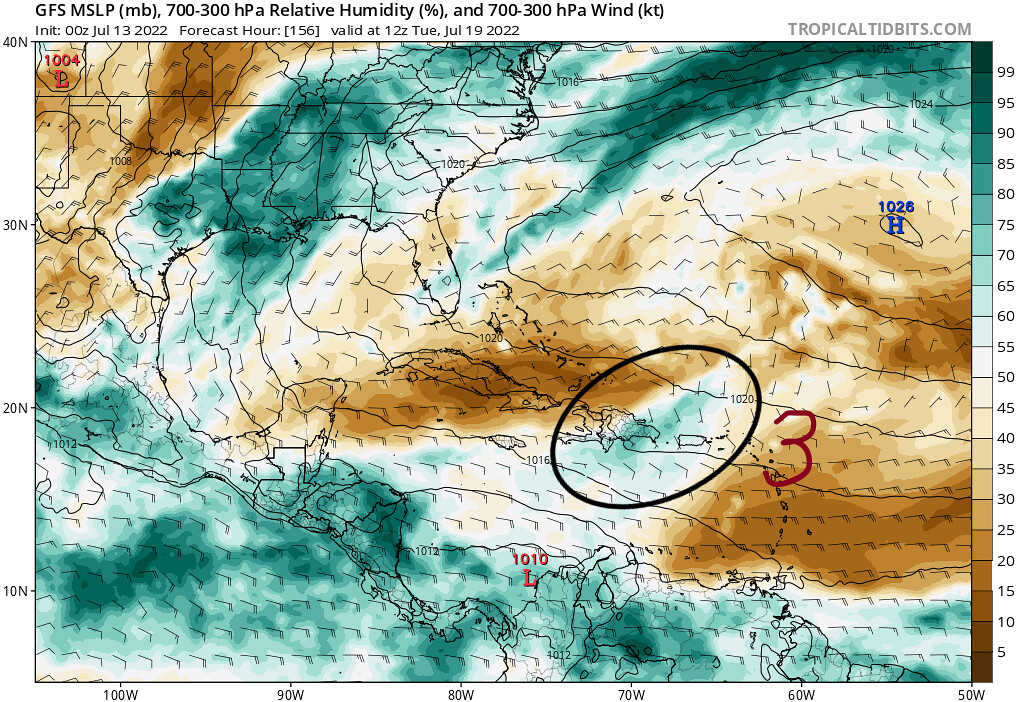
For the most part, though, the region where our Systems 2 and 3 will be tracking through will still be to the south of this belt of greater wind shear. However, System 2 will continue to struggle with dry air, with its signature on the mid- and upper-level relative humidity graphic above greatly diminishing by Saturday evening. What is still visible, though, is System 3 – although it will also have to battle with some dry air, the System 2 did help to moisten the atmosphere before this disturbance’s arrival. This, along with the light wind shear and warm sea surface temperatures will certainly allow this system a chance to get somewhat organized before it passes the Lesser Antilles by Sunday.
Unfortunately for this disturbance, as it approaches the second upper-level low that will be over the Caribbean early next week, the wind shear will increase and models are depicting the system having a much harder time developing convection, allowing drier air to work its way into the system by the time it reaches the Caribbean Sea.
Therefore, it looks like the only chance for this system to develop would be between now and this weekend. Both the European and the American models have the disturbance becoming somewhat better organized during this time, however the American GFS model shows a much more organized system by tomorrow afternoon.


In both solutions, however, this initial strengthening is not enough for this disturbance to overcome the poor environment that lays ahead. Nonetheless, this disturbance is still something to keep an eye on as a period of disturbed weather may affect the Lesser Antilles this weekend.
Conclusions


The threat for a disturbance to develop into a signficant tropical system is relatively low at this time in the Atlantic Basin, thanks to some relatively strong wind shear across much of the Tropical Atlantic. With that being said, just because nothing is likely to develop, doesn’t mean that there won’t be impacts. As we talked about earlier, a disturbance in the Gulf of Mexico that the National Hurricane Center is watching for its potential to develop into a tropical storm or tropical depression will continue to bring heavy rain across to the Central Gulf States.
As it is still only mid-July, the Atlantic Hurricane Season is typically quiet. However, within the next few weeks, expected tropical cyclone activity to increase as we head into August and September, the most active months for the Atlantic Hurricane Season.


