Starting tonight and going through to Friday, we’re seeing a change in the weather pattern that’s bringing warmer temperatures and more moisture from the Gulf of Mexico. This means we could see some light rain showers starting today. Anything that may develop will be rather light.
The good news is that temperatures are going to be quite pleasant, with daytime highs reaching into the mid to upper 60s and overnight lows not far behind in the mid to upper 50s by Friday morning. That’s pretty warm for this time of year, and we’ll also see quite a bit of cloud cover.
By Friday, expect another cloudy, warm, and rainy day as the weather pattern continues to evolve. The warmth and moisture are part of a larger shift in the weather system, with a subtropical ridge moving over the Caribbean Sea. That means, despite the clouds, temperatures will remain about 10 degrees Fahrenheit above what’s typical for this time of year, with highs in the low to mid-70s.
As we look ahead to Saturday and into next Wednesday, the forecast calls for continued shots for rain thanks to a complex weather pattern that includes a low-pressure area and a front that’s going to stall out. This setup will bring in more moisture, raising concerns for heavy rainfall and flooding. While we’re not currently forecasting flash flooding, it’s something to be mindful of, especially if the rain comes down quickly.
On top of that, we may also have a chance or a few severe storms on Sunday, too. It is a low=end risk, but I wouldn’t be surprised if the SPC blankets parts of the area with a Slight Risk for severe weather. The CIPS Analogs continue to show similar events in the past have produced severe weather.
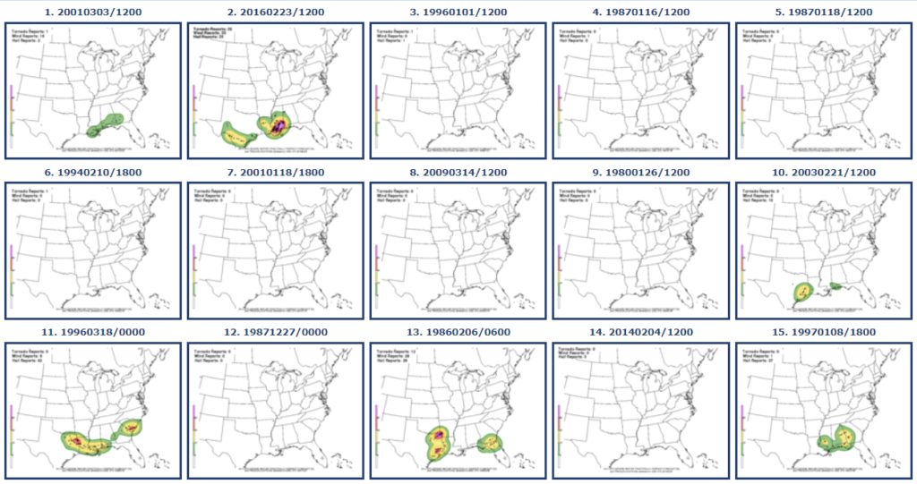
In fact, the No. 2 analog ended up being a Moderate Risk day. Biggest difference between Sunday and that day is that 2/23/16 had much more ‘umph’ than is currently shown in the lower levels.
But it is definitely worth monitoring.
Rain and storm chances will persist into early Monday but should start to move out of the area by Tuesday morning.
LOOKING AHEAD
i know there has been a lot of buzz on Ye Olde Internets about some big shot of cold coming as we move through the second half of February.
And while it will be cooler, and there may even be a few nights where we get down below freezing, I don’t think this is “big big” cold.
Looking at the EC-VAREPS data, which looks out through the next 40 days, the temperature and precipitation data for the area shows a handful of days with temperatures cooling down below 40F overnight, but nor big drastic cold. It also shows a few days where afternoon high temperatures get stuck in the 40s and 50s, too.
Will it be much colder in other places? I think so. Chances are that the brutalest of the cold will likely be up in the Great Lakes and Northeast (where it should be). But down here we are talking about a few days with colder overnight lows down around freezing and highs that peak around 50F.
So what about the maps, then? Well, I think part of the buzz is likely about the colors.
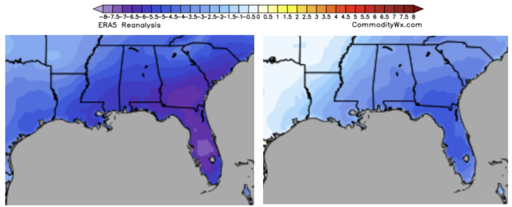
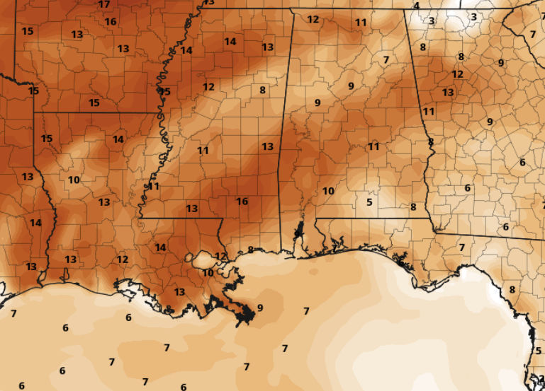
The maps above look very cold. They show the average temperature for the last week in February. But they show temperatures in the area between about 2F and 7F below normal. And that is averaged out over a full week.
But normal is an afternoon high of about 68F and an overnight low of 40F. So, even at its coldest – 7FF below normal – we are looking at a high of 61F and a low of 33F as an average for the entire week. Certainly nothing major. And because it is an average across a week, there is a good chance it is colder for a few days and then warmer for some others.
REGIONAL DAY TO DAY FORECAST
Thursday: Mostly sunny in the morning, then becoming mostly cloudy. Highs in the lower 70s. Southeast winds 5 to 10 mph.
Thursday Night: Mostly cloudy. Patchy fog after midnight. Not as cool with lows in the mid 50s. Southeast winds 5 to 10 mph.
Friday: Mostly cloudy. A slight chance of showers in the afternoon. Highs in the mid 70s. South winds 5 to 10 mph with gusts up to 20 mph. Chance of rain 20 percent.
Friday Night: Mostly cloudy. A slight chance of showers after midnight. Lows around 60. Southeast winds 5 to 10 mph. Chance of rain 20 percent.
Saturday: Mostly cloudy with a 40 percent chance of showers. Highs in the mid 70s.
Saturday Night: Cloudy with a slight chance of thunderstorms. A chance of showers. Lows in the upper 50s. Chance of rain 50 percent.
Sunday: Cloudy with a slight chance of thunderstorms. A chance of showers in the morning, then showers likely in the afternoon. Highs in the lower 70s. Chance of rain 70 percent.
Sunday Night: A slight chance of thunderstorms. Showers. Lows in the upper 50s. Chance of rain 80 percent.
Monday: A slight chance of thunderstorms in the morning. Mostly cloudy with a chance of showers. Highs in the mid 60s. Chance of rain 50 percent.
Monday Night: Mostly cloudy with a slight chance of showers in the evening, then partly cloudy after midnight. Much cooler with lows in the upper 30s. Chance of rain 20 percent.
Tuesday: Sunny. Highs around 60.
Tuesday Night: Partly cloudy. Lows in the upper 30s.
Wednesday: Mostly sunny. Highs in the lower 60s.


