QUICK SUMMARY: Over the next few days, expect warmer-than-average temperatures in the Lower Mississippi Valley due to a high-pressure system, with highs reaching into the 70s. Clouds will gather and there’s an increasing chance of rain starting late Thursday, continuing through the weekend. The warm trend and rain chances carry into early next week, with potential for heavy rainfall over the weekend due to a strong jet stream and moisture flow.
DETAILED FORECAST
There’s a large area of high pressure building over the Lower Mississippi Valley, which is basically like a big ‘bubble’ of calm and stable air. This is happening as we’re squeezed between two other weather systems – one over the west coast and another that’s moving away from us over the Atlantic. Because of this high pressure, we can expect winds from the south to bring in warmer air than usual for this time of year. Temperatures will likely reach the upper 60s to lower 70s during the afternoon, which is warmer than normal.
Clouds will start to gather from the west later in the day due to moisture moving in from the Rockies, leading to partly cloudy skies, especially to the west of the Mississippi River.
Tonight, the high pressure will get even stronger, and with more clouds around, it won’t get as cool as it has on previous nights. We’re looking at overnight temperatures staying in the lower 50s to upper 40s in the west, and in the mid to lower 40s in the east.
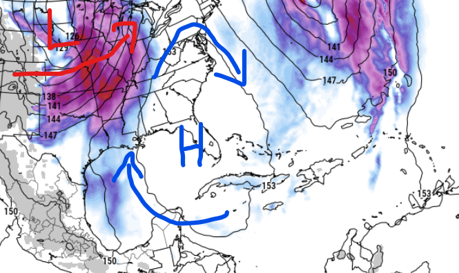
From Thursday to Friday, the high pressure will stretch from the Gulf of Mexico all the way to the Appalachian Mountains. We’ll have a south wind that brings in more moisture and warmth as the week progresses. This is in response to a cold air system moving across the northern Plains and a surface low and cold front moving across the Great Lakes towards Hudson Bay and extending down into the Ohio Valley and our region.
There’s an unusually strong high-pressure area developing over the Caribbean, which will lock in a strong jet stream – a fast-moving ‘river’ of air high in the sky – coming from the southwest. This setup, combined with increasing moisture, is going to lead to higher chances of rain starting late Thursday evening and continuing through the weekend.
Temperatures will be about 5 degrees above normal on Thursday, and by Friday, we could be 10 degrees above the average, with highs in the low to mid-70s. Overnight temperatures will also be quite warm for this time of year, especially by Friday morning.
As for the weekend and early next week, we’re watching another high-pressure system build over the Pacific states, while another weather system is expected to dive down towards the southern Plains by the end of the weekend. This means we could see some strong winds aloft and lots of moisture, leading to the possibility of heavy rain over the weekend.
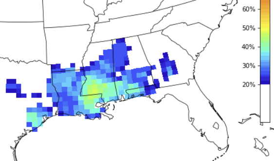
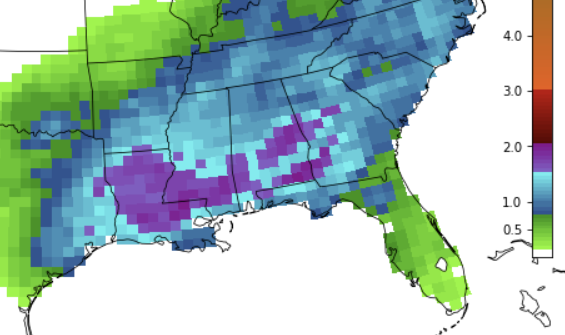
The chance of severe weather seems to be limited to areas south of HWY 84. But everyone looks to have a shot for heavy rain. And with how wet things have been recently, there’s a potential for flooding, especially in local rivers.
The weather pattern for early next week is becoming clearer, with a compact system expected to bring rain and storms through Monday, which should clear out by Tuesday evening.
REGIONAL DAY TO DAY FORECAST
Today: Sunny. Highs around 70. East winds 5 to 10 mph, becoming southeast with gusts up to 20 mph this afternoon.
Tonight: Partly cloudy. Lows in the mid 40s. Southeast winds 5 to 10 mph.
Thursday: Partly sunny. Highs in the upper 60s. Southeast winds 10 to 15 mph.
Thursday Night: Mostly cloudy. Not as cool with lows in the mid 50s. Southeast winds 5 to 10 mph.
Friday: Mostly cloudy in the morning, then becoming partly sunny. Highs in the mid 70s. South winds 10 to 15 mph.
Friday Night: Mostly cloudy. Lows in the upper 50s.
Saturday: Mostly cloudy with a chance of showers. A slight chance of thunderstorms in the afternoon. Highs in the mid 70s. Chance of rain 50 percent.
Saturday Night: Mostly cloudy with a chance of showers with a slight chance of thunderstorms. Lows around 60. Chance of rain 50 percent.
Sunday: Mostly cloudy with a slight chance of thunderstorms. A chance of showers in the morning, then showers likely in the afternoon. Highs in the lower 70s. Chance of rain 70 percent.
Sunday Night: Showers likely with a slight chance of thunderstorms. Lows in the mid 50s. Chance of rain 70 percent.
Monday: Mostly cloudy in the morning, then becoming partly sunny. A 50 percent chance of showers. Highs in the mid 60s.
Monday Night: Mostly cloudy with a slight chance of showers in the evening, then partly cloudy after midnight. Much cooler with lows around 40. Chance of rain 20 percent.
Tuesday: Sunny. Highs in the lower 60s.


