Expect a beautiful day with clear skies thanks to high pressure settling over the area. As the system that brought any recent wet weather continues to move away, we’re in for dry conditions with no rain expected. It’ll be slightly warmer than usual temperatures for this time of year, with daytime highs reaching into the mid 60s. Heading into the evening, you might notice more clouds as moisture begins to move in from the west.
The rest of the workweek looks stable with high pressure influencing our weather, meaning we’ll have dry and increasingly warm days ahead. You can expect temperatures to gradually rise, with highs about 5 to 10 degrees above average later in the week. By Friday, morning, with a slight chance for some drizzle, temperatures will be quite mild for this time of year, potentially in the low to upper 50s.
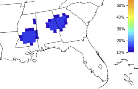
Looking ahead to the weekend, it appears we could be in for a rainy few days. An area of heavier rain may set up across the region, thanks to a combination of high moisture levels and favorable winds aloft. While we may also see some thunderstorms, it’s too early to know specifics but the CIPS Analogs data supports a chance for widespread low-end severe weather. Or, in other words, a chance for a line of storms to move through with gusty wind and small hail. The tornado threat remains on the low-end of the scale.
Once we get through the storms we clear back out for the beginning of next week.
REGIONAL DAY TO DAY FORECAST
Tuesday: Sunny. Not as cool with highs in the mid 60s. North winds 5 to 10 mph.
Tuesday Night: Clear. Lows in the upper 30s. North winds around 5 mph.
Wednesday: Mostly sunny. Highs in the upper 60s. East winds 5 to 10 mph, becoming southeast in the afternoon.
Wednesday Night: Partly cloudy. Lows in the mid 40s. Southeast winds 5 to 10 mph.
Thursday: Partly sunny. Highs in the upper 60s.
Thursday Night: Mostly cloudy. Not as cool with lows in the mid 50s.
Friday: Mostly cloudy. A slight chance of showers in the afternoon. Highs in the lower 70s. Chance of rain 20 percent.
Friday Night: Mostly cloudy. A slight chance of showers in the evening, then a chance of showers after midnight. Lows in the upper 50s. Chance of rain 30 percent.
Saturday: Mostly cloudy with a chance of showers with a slight chance of thunderstorms. Highs in the lower 70s. Chance of rain 40 percent.
Saturday Night: Mostly cloudy with a chance of showers with a slight chance of thunderstorms. Lows in the upper 50s. Chance of rain 50 percent.
Sunday: Mostly cloudy with a slight chance of thunderstorms. A chance of showers in the morning, then showers likely in the afternoon. Highs in the lower 70s. Chance of rain 60 percent.
Sunday Night: Mostly cloudy with a chance of showers with a slight chance of thunderstorms. Lows in the lower 50s. Chance of rain 50 percent.
Monday: Partly sunny with a 20 percent chance of showers. Highs in the upper 60s.


