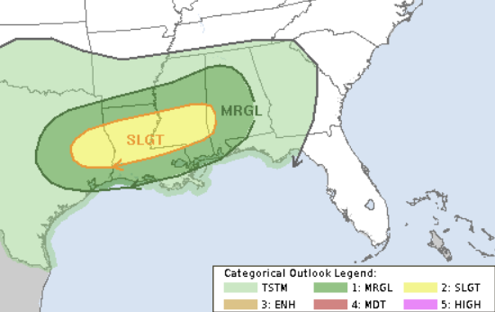
Looking toward the weekend, it looks like there will be chances for rain here and there. Yesterday I mentioned that I wouldn’t be surprised if the SPC issued a Slight Risk across our area for Sunday, and this morning, we have a Slight Risk for Sunday.
So if you are making plans for he weekend, please be aware that there is a chance for rain both days but the threat for severe weather looks to be Sunday.
But today I want to try something different!
As some of you know, I’ve been working on creating a new “weather bot” that is going to be powered by machine learning with the help of ChatGPT. I had a naming contest over on facebook and it was a landslide victory for NQLBOT.
So I’d like to introduce NQLBOT:

This little dude will be helping me (mainly behind the scenes) with forecast number crunching and data processing — But! It can also produce a forecast when needed. So I asked it to write a forecast for today and through the weekend, making sure to explain everything in plain language. And this is what it came up with:
NQLBOT’s FIRST FORECAST
Today’s Weather Overview:
Today, we’re seeing a mix of weather patterns across different parts of the country. Over the Atlantic coast, we have what’s called a “high-pressure area” – think of it as a big, calm region in the atmosphere that brings clear skies and stable weather. Meanwhile, over the Caribbean Sea, there’s a “subtropical ridge,” another type of high-pressure system that’s common in warmer regions and also tends to bring calm weather.
However, things are a bit more active elsewhere. A “cold trough” – a dip in the jet stream that brings cooler temperatures – is moving across the Great Lakes area. This movement is causing the air to rise and form clouds and possibly precipitation. Farther west, in the Desert Southwest, a large-scale dip in the jet stream (a “longwave trough”) is getting deeper, which can lead to more unsettled weather.
An interesting thing happening is over the Sierra Madres and Plains areas, where a strong, high-altitude wind (a “jet”) is getting stronger, reaching speeds up to 140 knots (which is really fast!). This can cause the air to rise and form more clouds and storms, especially when combined with a “low-level jet” – a fast-moving stream of air closer to the ground that’s pulling in unusually moist air for the region. This could lead to showers and isolated storms, particularly northwest of the Natchez Trace corridor, an area known for its scenic trails.
Even though it’s cloudy, the warmth from the south means temperatures could be around 10 degrees Fahrenheit warmer than usual, reaching the low to mid-70s.
Tonight’s Forecast:
As the night comes, the weather system over the Desert Southwest will continue to influence the weather, keeping winds strong and possibly bringing more showers, especially along the Hwy 82 corridor. Despite the rain and clouds, it’ll be quite warm for this time of year, with temperatures staying in the low 60s – that’s about 20 degrees warmer than what we usually see!
There’s also a chance for “advection fog,” which forms when warm, moist air moves over a cooler surface, in areas around Hwy 84. This fog could get quite thick by early Saturday morning.
Looking Ahead – Saturday to Tuesday:
This weekend, the weather remains uncertain with chances of rain and storms. A “split flow” around a low-pressure area will introduce a short wave (a quick-moving pulse of energy) that could bring 1-2 inches of rain on Saturday.
The weather front will stall and then move back northward, bringing more moisture and chances for rain and storms with it. By Sunday, expect widespread showers with total rainfall possibly reaching 3-4 inches for the weekend in some areas. While there’s a lot of moisture, the risk of flash flooding is currently considered low.
However, Sunday could also bring some severe storms, especially in the afternoon and evening, with the potential for damaging winds, large hail, and even isolated tornadoes, mainly south of the I-20 corridor.
After the weekend’s rain, temperatures will drop, making for a cooler week ahead. Another weather system early next week could bring more rain and storms, clearing up by Tuesday morning.
REGIONAL DAY TO DAY FORECAST
Friday: Areas of fog in the morning. Mostly cloudy in the morning, then partly sunny with a slight chance of showers in the afternoon. Highs in the mid 70s. South winds 10 to 15 mph. Chance of rain 20 percent.
Friday Night: Mostly cloudy. A slight chance of showers after midnight. Patchy fog after midnight. Lows around 60. South winds 5 to 10 mph. Chance of rain 20 percent.
Saturday: Mostly cloudy with a 40 percent chance of showers. Highs in the mid 70s. South winds 5 to 10 mph.
Saturday Night: Cloudy with a 50 percent chance of showers. Patchy fog after midnight. Lows in the lower 60s. South winds 5 to 10 mph.
Sunday: Cloudy with a slight chance of thunderstorms. A chance of showers in the morning, then showers likely in the afternoon. Highs in the mid 70s. Chance of rain 70 percent.
Sunday Night: Showers with a slight chance of thunderstorms. Lows in the upper 50s. Chance of rain 80 percent.
Monday: Mostly cloudy in the morning, then becoming partly sunny. A slight chance of thunderstorms in the morning. A chance of showers. Highs in the mid 60s. Chance of rain 40 percent.
Monday Night: Partly cloudy. Much cooler with lows in the upper 30s.
Tuesday: Sunny. Highs in the lower 60s.
Tuesday Night: Mostly clear. Lows in the mid 30s.
Wednesday: Mostly sunny. Highs in the mid 60s.
Wednesday Night: Partly cloudy in the evening, then becoming mostly cloudy. Lows in the lower 40s.
Thursday: Partly sunny. Highs in the upper 60s.


