Starting off with a warm, misty morning, a humid airmass from the Gulf is present over us for the next few days. As many of us know, when it gets warm and humid for a few days, rain and thunderstorms are bound to follow.
Starting off today, we’ll have overcast skies from I-20 south to the coast. Areas north of I-20 are currently experiencing rain and some thunderstorms. Temperatures will reach the mid-70s by the afternoon.

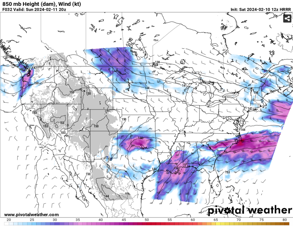
First off, let’s talk the upper atmosphere to establish what’s going on with the possible severe weather for the next couple of days. A longwave trough in the southwest US is moving slowly east along with an upper-level jet in the Great Lakes region. The trough itself will start digging in and gaining strength, however much later than any extreme effect it would have on us. The 850mb flow shows us where the moisture is coming from for the next couple of days, pulling straight from the Gulf.
The location of the upper level jet also plays into where the majority of rain and severe weather will be for Saturday. Most of it will stay around northern Louisiana and central to northeast Mississippi. Looking at the Significant Tornado parameter for today, the worst of it is hanging around central/northern Louisiana.
While the parameter looks to be on the low side, this doesn’t mean it isn’t possible for a tornado or two to develop. Other than the tornado threat, the main concerns for today into tonight for Louisiana and central/north Mississippi will be heavy rain and wind gusts.

For areas south of I-20 on Saturday, we’ll see a more limited chance of rain with a few pop-up showers from the evening into overnight. Sunday, however, is when we have our turn of the severe weather threat. As the low-level jet sets up towards the Louisiana/Mississippi Gulf Coast, the atmosphere will have plenty of moisture to work with to set up some severe thunderstorms and even some possible tornadoes.
There is a decent amount of instability and dewpoints in the mid-60s, and most of this looks to come to a head in the afternoon. The setup looks like mostly discrete cells riding along the stalled frontal boundary which means that there will be a low and mid-level driving force to help with some shear. Most of this looks to happen around mid-afternoon until after sunset. And while I said the SigTor parameter is on the lower side, it still is possible, especially with developing discrete cells. Our other main threats for tomorrow will be wind gusts up to 40 mph and possible hail.

Overnight Sunday and Monday, we’ll have some lingering showers and thunderstorms. The stalled front from Sunday will eventually be carried off by the upper level trough and pushing the rain east into Alabama, Florida and Georgia later in the day.
Expect a possible inch or two of rain especially closer to the coast, but no severity with these storms for Louisiana or Mississippi. Conditions will eventually clear up and we’ll see the sun again with temperatures in the upper 60s.
Stay safe this weekend and be sure to keep your phone or radio close for any upcoming alerts!
[wpcode id=”41179″]
Regional Day-to-Day Forecast
Today – Drizzle and showers possible in the afternoon. Otherwise, cloudy, with a high near 76. South wind 5 to 10 mph, with gusts as high as 20 mph. Chance of precipitation is 20%.
Tonight – A chance of showers, with thunderstorms also possible in the overnight hours. Patchy fog after midnight. Otherwise, cloudy, with a low around 64. South wind around 10 mph, with gusts as high as 20 mph. Chance of precipitation is 50%. New rainfall amounts of less than a tenth of an inch, except higher amounts possible in thunderstorms.
Sunday – A chance of showers and thunderstorms in the morning, then thunderstorms possible in the afternoon. Some of the storms could be severe. Patchy fog in the morning. Otherwise, mostly cloudy, with a high near 75. South wind 5 to 10 mph, with gusts as high as 20 mph. Chance of precipitation is 70%. New rainfall amounts between a tenth and quarter of an inch, except higher amounts possible in thunderstorms.
Sunday Night – Showers and possibly a thunderstorm overnight. Some of the storms could be severe. Low around 60. South wind 5 to 10 mph. Chance of precipitation is 90%. New rainfall amounts between a quarter and half of an inch possible.
Monday – Scattered showers and thunderstorms until the afternoon. Partly sunny, with a high near 68. West wind 5 to 15 mph, with gusts as high as 25 mph. Chance of precipitation is 40%.
Monday Night – Partly cloudy, with a low around 38. West northwest wind 10 to 15 mph, with gusts as high as 30 mph.
Tuesday – Sunny, with a high near 61. North northwest wind 5 to 10 mph, with gusts as high as 20 mph.
Tuesday Night – Mostly clear, with a low around 36. North northwest wind around 5 mph becoming calm in the evening.
Wednesday – Sunny, with a high near 66. Calm wind becoming south southeast around 5 mph.
Wednesday Night – Partly cloudy, with a low around 39.
Thursday – Mostly sunny, with a high near 70.
Thursday Night – Mostly cloudy, with a low around 45.
Friday – Scattered showers. Mostly cloudy, with a high near 63. Chance of precipitation is 30%.
[wpcode id=”41149″]


