
Looking at the next 36 hours, we’ll have our hands full with a few rounds of possible severe weather. Around 10 am tomorrow, we’ll see storms begin to pop up from north central to eastern Louisiana. After that, the severe weather commences.
I’ll go by a 3-hour interval and talk about where the storms will develop.
10am – 1pm


Starting off around 10am, storms will start firing off around the I-49 corridor all the way to I-10/I-12 corridor. Areas around Alexandria will be the first to experience a possible supercell within the first few hours. Around Baton Rouge and New Orleans and north of I-12 will see some cells develop and begin moving north. By 12pm, a few cells north of Lake Pontchartrain and along the MS/LA may bring some slight chance of severe weather with a tornado and some hail possible. By 1pm, several cells have developed along I-55 all the way to Wayne County.
1 – 4 pm

Around 2pm, many of the cells will mature and bring more of the hail, wind, and possible tornadoes. Areas along I-59 from Slidell to Meridian should be aware of the incoming weather. From St. Tammany Parish to Purvis, Hattiesburg, Laurel, and Meridian should all be on alert at this time as storms are moving northeast.
5 – 8pm
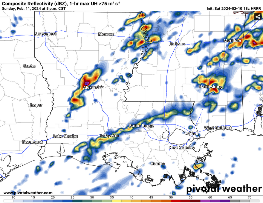
By 5pm, an organized line of storms developing from the low-level jet will begin to move north from Louisiana into Mississippi, but not before another round of possible severe cells will affect areas around Hattiesburg, Collins and Ellisville up I-59 to Meridian. Wind, hail, and tornadoes are all possible with this round of storms.

Moving northeast, a thin line of storms from the jet will head towards south Mississippi and will likely bring some possible hail and strong winds with it. This will span across the Pinebelt from Natchez to State Line. Afterwards, this line will dissipate as it reaches I-20.
1 – 4am

Past midnight, the cold front will move further east towards southwest MS/southeast LA. Another round of storms will develop west of I-59 from Marion County to Jones County which will include areas of Purvis, Hattiesburg, Ellisville, Laurel, up to Sandersville. A series of semi-organized cells will form around 1am to 4 am moving northeast. A tornado can’t be ruled out, and hail and straightline winds are possible. They look to weaken as they move towards Meridian.
5 – 8am

At last, we’ll see our final round of storms, albeit a fairly longer one. The severe storms look to move further east along the MS/AL border from Wayne County southward to the coast. As they lose intensity, we’ll see a more organized line of storms develop and cover eastern Louisiana, the Mississippi coast, and areas along and east of I-59. Expect some heavier rain and thunderstorms in the morning. The rain will linger until the early afternoon and eventually give way to partly cloudy skies.

[wpcode id=”41179″]
[wpcode id=”41149″]


