The more active weather pattern begins later tonight and into tomorrow. And it will last for the next – roughly – 10 days.
It looks like there will be chances for rain on a handful of days during the next week and a half, but only two days where the rain will feature a chance for “dangerous” weather. Right now it looks like Monday (tomorrow) and then next weekend will feature storms with the potential for severe weather.
So far that threat is pretty low for the Southern MS/AL/LA region, but it certainly isn’t zero.
Looking at the data from the GFS computer weather model, atmospheric parameters for severe weather look pretty sparse for Monday. And rather robust for this upcoming weekend.


It is important to note that I keep saying, “this weekend” or “Saturday/Sunday” because there is still a fair bit of wiggle room for the timing of that system.

The above map is a top-down look at the earth. Sometimes it can be a bit difficult to wrap your brain around (or at least, I struggle with it). Basically the north pole is in the middle, the US is on bottom, Europe is in the middle on the right and Asia is in the middle and on the upper left.
The black circle is where the energy for this next weekend’s storm system is. That is north of Scandinavia and Siberia. And the dashed line is where the model thinks it will move during the next eight days. Rather serpentine.
And any deviation from that path shown is going to change the eventual timeline for where the system eventually goes, when the system arrives there, how strong it will be, and thus, what the impacts will be.
So there is still a lot to hammer out.
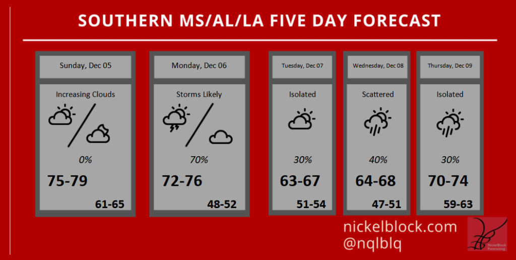
Day to Day Forecast
Today
Areas of dense fog in the morning. Partly cloudy. Highs in the upper 70s.
Tonight
Increasing clouds. Temperatures nearly steady in the mid 60s.
Monday
Mostly cloudy with storms possible. Severe weather can’t be completely ruled out, but is not anticipated. Highs in the mid 70s. The chance of rain 70-percent.
Monday Night
Cloudy with lingering showers possible. Cooler. Lows around 50.
Tuesday
Cloudy with a 30-percent chance of regular rain. Cooler. Highs in the lower 60s.
Tuesday Night
Clouds stick around with showers possible overnight. Lows in the lower 50s. The chance of rain 40-percent.
Wednesday
Mostly cloudy with a 40-percent chance of showers. Highs in the mid 60s.
Wednesday Night
Partly cloudy. Lows in the upper 40s.
Thursday
Partly cloudy with a 30-percent chance of showers and storms. Highs in the lower 70s.
Thursday Night
Mostly cloudy. Warmer. Lows in the lower 60s.
Friday
Mostly cloudy with a 40-percent chance for showers and storms. Highs in the upper 70s.
Friday Night
Mostly cloudy. Lows in the upper 60s.
Saturday
Mostly cloudy with a 40-percent chance of showers and thunderstorms. Severe weather can’t be ruled out. Highs in the upper 70s.
Graphical Forecast