We’ve certainly flip-flopped weather patterns in the past few weeks and that’s going to hang around a little longer! The atmosphere is moving with an anomalously low trough in the Great Lakes helping to contribute to our cooler than average temperatures and more active weather patterns. Plus, the best news, more rain!

Atmospheric Setup
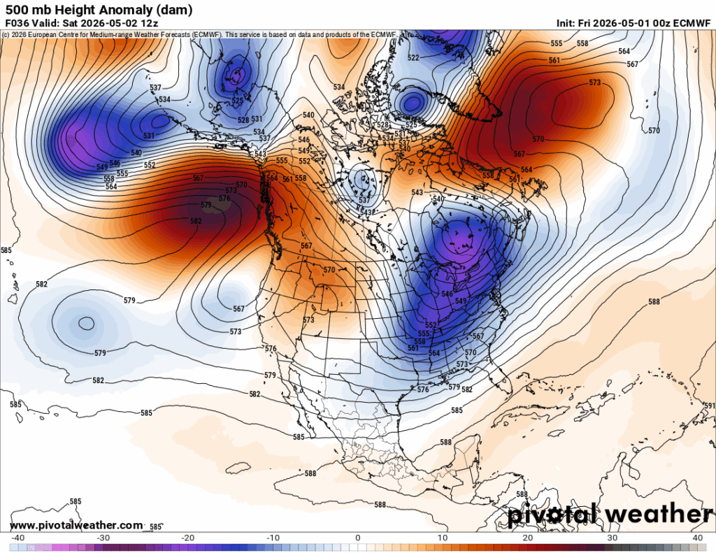
Before I go into my usual spiel about the weekend and the following week, I’ll describe what’s going on in the lower and upper atmosphere first. Looking at the height anomaly map above, we can see a few features that will define our next week. The first is the anomalously low closed trough north of the Great Lakes in Quebec. The trough isn’t moving fast and will contribute to our lower-than-average temperatures and incoming rain.
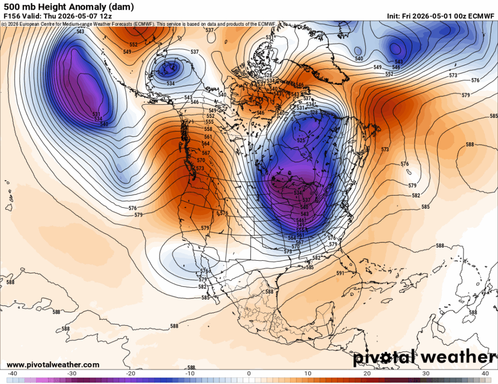
If we move out about 6 days from Saturday, we’ll notice that the low height anomaly is still there! The incoming shortwave trough that brings the rain on Wednesday is essentially absorbed by the large trough. Another thing of note is the large ridge that was over Alaska has shifted to the east towards the Pacific Northwest which will contribute to warmer than average temperatures and less rain.
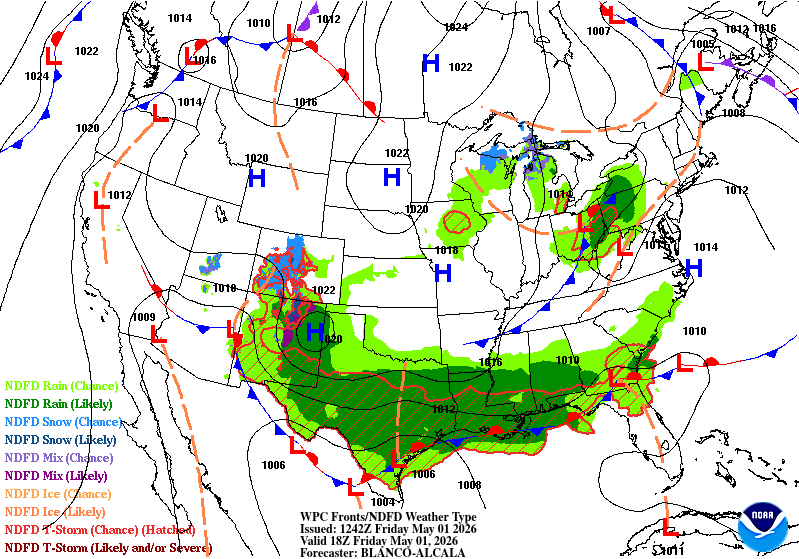
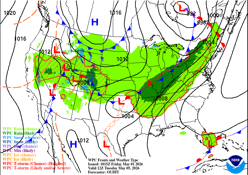
Now let’s look at the surface. Comparing today’s front map and Tuesday’s, we can wee that the low pressure system develops right over the Hudson Bay area, in a similar location to the upper level trough. The low will move in by Wednesday bring in more rain and thunderstorms before we have a brief period of calm weather. A high pressure system will develop over the eastern US before it moves out in-lieu of the cold front. The low pressure systems will move in towards the west before they begin to dry out.

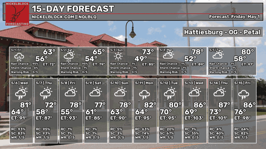
Today
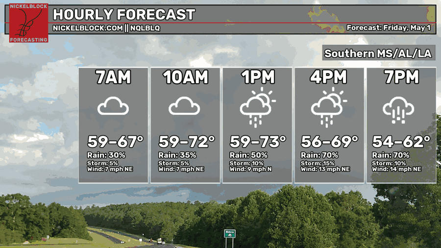
We’re expecting rain just about all day today! You’ll have to keep your plans indoors as more showers will move in by the mid-afternoon and we’ll only have brief periods between each squall. Severe weather is expected for those near the mouth of the Mississippi in Louisiana. Otherwise, it’s mainly going to be rain with a few thunderstorms. Highs will reach the upper 60s to low 70s during the day and the low 50s overnight. Rainfall totals may exceed 2 inches.
Tomorrow
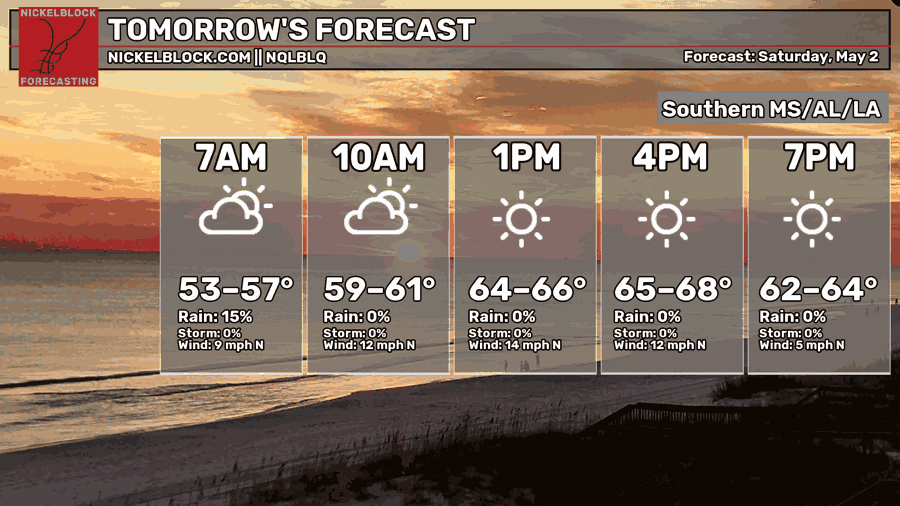
The rain will move out by the early morning tomorrow leaving us with clear skies and some gusty north winds. We’ll reach the mid to upper 60s during the day which is a decent blast of cool for this time of year. Overnight, we’ll fall into the upper 40s. Yep! A cool night ahead, so dress and warm up accordingly!
Sunday
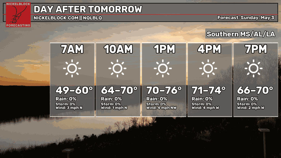
The winds will calm down by Sunday, and we’ll be a little chilly in the morning especially if we’re headed to church or exercising. It’ll be a beautiful day with hardly a cloud in the sky with a high in the low to mid 70s across the area. Overnight, we’ll fall into the low 50s with clear skies.
Next Week
As we roll into the work week, temperatures will stay just below our seasonal norms. Highs will move from the upper 70s to the low 80s and lows will eventually move from the low 50s to the mid 60s. This is due to the front I mentioned earlier contributing to higher dewpoints and therefore a higher threshold for moisture and saturation temperature.
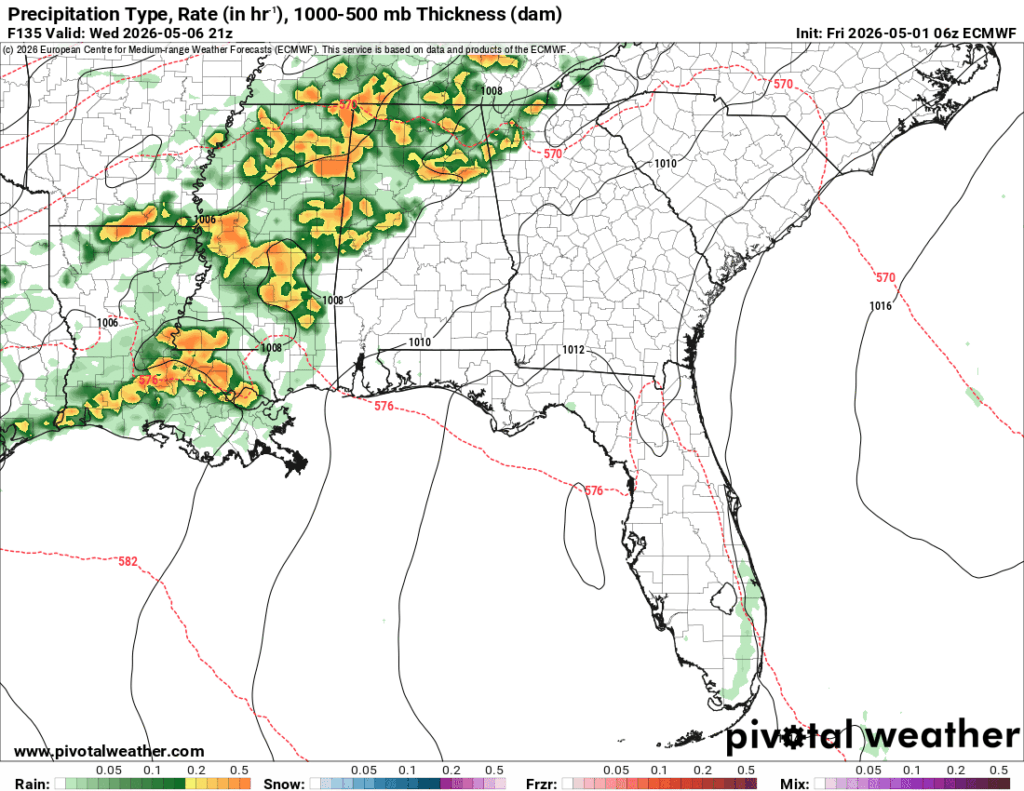
Wednesday also looks like our next severe weather concern. The SPC hasn’t placed an outlook on it yet, but the line does look somewhat organized. The main problem is that it’s located at the tail end of the low pressure system and looks to develop fairly quickly over a short period. This could hinder much of the major risk development before it can get started. Can this change? Absolutely. As the models update, we’ll see what this system can look like and how it evolves as it moves towards the southeast.
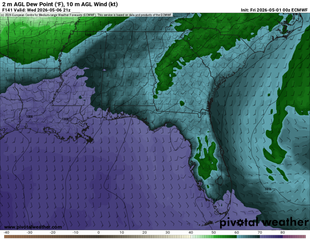
One big contributing factor I mentioned earlier is the dewpoint spike we receive before the storm rolls in. This moves in fairly quickly early Wednesday and drops early Thursday. While dewpoints reach around 70 which is great for severe development, it also drops pretty quickly. Convection is readily available with this system as well. Overall, it’s tough to say what this will do just yet but we’re going to keep an eye on it.
Through the rest of the week, we’ll go back to just under seasonal norms. Highs will be in the upper 70s to low 80s with lows in the upper 50s. Not a bad way to end the week!