Author: Nick Lilja
|| Published: 12/17/2020 at 10:19pm
A “White Christmas” is designated by the National Weather Service as a Christmas Day with 1″ of snow on the ground at any time during the day.
So, I received a text from good friend, and former WDAM’er, Ryan Moore today pointing out that a few of the national-level weather apps were showing a chance for snow on Christmas Eve night for south Mississippi…. I knew there was about the be an avalanche of questions.
My knee-jerk reaction was one of Lee Corso:
via GIPHY
After looking into the model data, I found the problem.
It’s only one model…
The trend from the model guidance shows a cooler than normal Christmas Day. It also shows a chance for rain – and perhaps storms – on Christmas Eve.
The data has been pretty consistent with this – general – forecast for the last two or three weeks.
Today, though, the model data showed barely enough lingering moisture in combination with much cooler temperatures to squeeze out a chance for some pretty cold drizzle or even a few ice crystals before things fully dried out.
Barely.
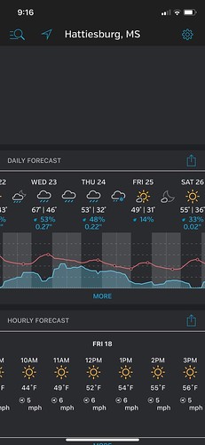
Here is a look at the model data
Not a lot of moisture at all. And it isn’t like 6 hours before this there was much moisture either. As it looks just as dry.
And it is only a single model. Looking at some of the other data that is available regarding the same point in time, the chance for snow is is non-existent.
So it looks like the model data being used within these apps is being pulled from just a single model.
Other models show a different outcome
Notice that the temperature spread (light blue shaded area) shows an equal chance the area is 22F on Christmas morning OR 67F at the same time. That is a pretty big spread.
The two lines show the operational model and the average of the ensemble. And while both show temperatures potentially cold enough for snow, the problem is there isn’t likely to be much moisture left to snow.
Right now both the GFS and the ECMWF – as well as their ensembles – show plenty of cold air spilling into the area behind the chance for rain around the 23rd/24th. Temperatures on Christmas morning are looking closer to 30F than the 40F shows in data previously. That is a reasonably large change.
And while I’m not totally onboard with that change, yet, I think it is time to start preparing for a chilly Christmas. But, sadly, not a white one along the Gulf Coast.
Author of the article:
Nick Lilja
Nick is former television meteorologist with stints in Amarillo and Hattiesburg. During his time in Hattiesburg, he was also an adjunct professor at the University of Southern Mississippi. He is a graduate of both Oregon State and Syracuse University that now calls Houston home. Now that he is retired from TV, he runs this site and its app in his spare time.
 My knee-jerk reaction was one of Lee Corso:
via GIPHY
After looking into the model data, I found the problem.
My knee-jerk reaction was one of Lee Corso:
via GIPHY
After looking into the model data, I found the problem.
 Not a lot of moisture at all. And it isn’t like 6 hours before this there was much moisture either. As it looks just as dry.
And it is only a single model. Looking at some of the other data that is available regarding the same point in time, the chance for snow is is non-existent.
So it looks like the model data being used within these apps is being pulled from just a single model.
Not a lot of moisture at all. And it isn’t like 6 hours before this there was much moisture either. As it looks just as dry.
And it is only a single model. Looking at some of the other data that is available regarding the same point in time, the chance for snow is is non-existent.
So it looks like the model data being used within these apps is being pulled from just a single model.
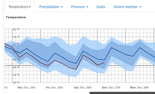 Notice that the temperature spread (light blue shaded area) shows an equal chance the area is 22F on Christmas morning OR 67F at the same time. That is a pretty big spread.
The two lines show the operational model and the average of the ensemble. And while both show temperatures potentially cold enough for snow, the problem is there isn’t likely to be much moisture left to snow.
Notice that the temperature spread (light blue shaded area) shows an equal chance the area is 22F on Christmas morning OR 67F at the same time. That is a pretty big spread.
The two lines show the operational model and the average of the ensemble. And while both show temperatures potentially cold enough for snow, the problem is there isn’t likely to be much moisture left to snow.


