As wintry temperatures descend on the Pine Belt, here is a quick update regarding a few hot topics…
Before you ask
The Top 3 questions I get are as follows:
1. Is it going to snow?
2. Will they cancel school?
3. Can I drive?
The answers, in order, are:
1. Unlikely.
2. Also unlikely. Though it may get delayed.
3. Most likely. But, some people will likely still end up in the ditch.
Yeah, Lloyd, I suppose the chance isn’t zero.
As cold air invades the area on Tuesday morning behind a cold front, there is a chance that a mix of rain, sleet and (it is a long shot, here) a few snowflakes may accompany it, too. Temperatures will be in the 30s, but the ground temperatures are currently in the 50s so accumulation of anything other than liquid water is very unlikely. Like very, very unlikely.
The forecast, in-depth
This is the kind of setup that makes most forecasters (myself as proof) lose hair. As a shallow cold front slides through the area, it is going to cool down the lowest 1500 feet of the atmosphere quite a bit.
So much so, that some model data shows the chance that precipitation may turn from rain showers to a mix of rain and sleet.

Precipitation rates will be pretty low, so it any precipitation does all it will be generally light. Because of that, it is unlikely that precipitation rates overcome the ‘warm’ ground, with soil temperatures in the 50s, to get any accumulations. Other than liquid water, that is.

This go-around it looks like the atmosphere is sufficiently saturated throughout with a temperature at almost 50 degrees up at 4000 feet. So despite this graph above showing a saturated DGZ with WAA occuring, there is too much warm air between it and us on the ground, for us to see snow.
That same graph does indicate that there is the outside chance that for an hour or so between 5am and 9am, there is a chance that rain does mix with sleet pellets.
You may be thinking, ‘well what does it take to get snow?’ in South Mississippi.
The chance that the precipitation falls as snow depends on (1) where you are, (2) where the area of lowest pressure moves, (3) how fast the cold air pushes south, (4) how deep the cold air is, (5) the direction vector of the moisture plume, (6) if the over-riding southwest flow is moist enough at the right levels, (7) if the dendritic growth zone can become saturated, and (8) the wet-bulb temperature through the atmospheric profile.
As well as a handful of other factors like (9) 500mb vorticity location, (10) 700mb vertical velocity, and (11) 200mb divergence.
Oh, and (12) if all of these things can happen in the (12a) right amounts (12b) at the right time (12c) in the right place and (12d) you are in that place and (12e) looking for it.
As you can see, for down in Mississippi… Sadly it isn’t as simple as just being 32 degrees.
Here is a helpful guide:

Why doesn’t the Gulf Coast see snow?
You probably didn’t ask this, but understanding why is an important first step toward understanding why there isn’t really a chance for it now. Because the Gulf Coast can get temperatures around freezing. In fact, it gets below freezing here often but there just isn’t any precipitation falling by the time that happens.
Generally that is because cold fronts at the surface are usually faster than the cold air aloft.
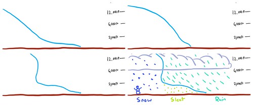
Take these graphics (Sure there are prettier graphics out there to explain this, but I don’t like stealing other people’s work. I’d rather made a rough sketch.) above, for example, they showcase how the area ends up with sleet and freezing rain. Generally our atmosphere has a warm patch about 2,000 to 6,000 feet off the ground. This is due to our proximity to the Gulf of Mexico.
Even when super strong cold fronts come barreling toward the Gulf, usually (1) the trajectory of the front (the direction it is coming from) tends to allow the warmer air aloft to hang around and (2) where the forcing / vertical motion are occuring will not line up where it needs to be, to give the area any snow. Instead the area gets sleet.
Possible vs Probable
I got a lot of kick-back on these two terms the last time I posted a weather forecast. Some folks were a bit perplexed that used the terms independent of each other, as they thought it meant the same thing. So I want to take some time to help everyone out. Probability is the measure of the likelihood of an event, the possibility is a measure of the chance that an event even exists.
For example, there is the possibility that it snows in the South next week. The possibility is, one-in-three. There are three possible types of precipitation on Tuesday: rain, sleet, snow. That’s it.
 But the probability that it snows is, at this point, given the available data, very low.
But why is that? Why isn’t it just yes or no?
Variability within the data is the key here. At this distance in time there are too many variables within the future forecast that are still unknowns. And those unknowns are ‘unknowns with high variance’ and so it throws a wrench in things. The graphic here illustrates how many possible outcomes there are when a decision matrix has three options and three steps.
Imagine if each choice at each step is reasonably accurate within the frame of reference established. Could you make an informed decision?
I would argue, probably not.
A good example of this conundrum, in this case may be the 850mb temperature (the temperature up at 4,000 feet) next Tuesday when precipitation will be falling in South Mississippi.
In this situation, the 850mb temperature is a big indicator of precipitation type. And right now, the data shows it will be above freezing. And above freezing melts snowflakes.
What you need to know
A cold front is going to turn a mild day on Monday into a very winter-like day on Tuesday. Monday when the sun goes down it will be in the upper 60s and low 70s. By the time the sun comes back up on Tuesday, the temperatures will be around 35. As the cold front exits there may be some lingering moisture around and just enough forcing to produce some precipitation – and what kind of precipitation is going to be dictated by many factors.
That is the main story. It will be quite cold on Tuesday compared to Monday. And it will be coldest when we all wake up and head to work or the kids head out to the bus stop.
There is an outside shot that some counties/cities may elect to delay school, even with a pretty low potential for impacts, just to be safe. And wouldn’t you rather school be safe with the kids than sorry?
For now, keep tabs on the forecast but prepare for the cold, not for any kind of ice storm or blizzard.


