Quite the eventful day across the area.
Where we stand now…
Tropical Storm Olga is still merging with a weakening cold front. That is providing some extra ‘umph’ to the showers and storms we are dealing with today and tonight.
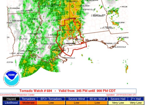
The Tornado Watch will remain in effect until 9pm for Clarke, Wayne, Jones, Forrest Lamar, Pearl River, Stone, George, Greene and Perry counties. There is a chance it gets extended overnight, but it looks like there will be a relative lull in the threat between about 8pm and midnight. More on that below.
Radar estimates show that the storms that moved through earlier dropped between 1″ and 4″ of rain across the area. With a few spots seeing even a tad more than that.
More rain is expected overnight.
The tornado threat
It looks like there will still be the threat of tropical tornadoes through midnight and likely through the overnight hours and until tomorrow morning around 6am.
But the threat will be rather limited. And the strength of the tornadoes will be weak.
Tropical tornadoes are a bit different than the normal tornadoes we get with cold fronts. Generally, they aren’t as big, they aren’t as devastating. But they are really difficult to find on radar and can spin up and break up in a matter of seconds. So they are very difficult to track and predict.

But again, the good news is these types of tornadoes are mostly known for tree damage, roof damage and fence damage. These aren’t the kind that loft homes in the air or flatten neighborhoods.
The flooding threat
The flooding threat will continue overnight, too. For those of you who live in low-lying areas or live in a place where flooding has caused you problems in the recent past, please pay close attention to the weather overnight and have a plan now for what you may do if overnight a Flash Flood Emergency is issued for your area.
Remember that a Flash Flood Emergency is different than just a Flash Flood Warning. A Flash Flood Emergency should be treated as a life-threatening situation that needs immediate action. Think of it like the flooding version of a tornado warning. Only, instead of seeking shelter, you need to head for higher ground.
As Tropical Storm Olga drifts north overnight, it looks like the Pine Belt may pick up an additional 2″ to 4″ of rain. While normally 2″ to 4″ of rain isn’t enough to cause us problems, it would be on top of the already saturated soils from today’s rains.

Right now, it looks like the I-59 corridor is going to be the place that deals with the most rains from the overnight rounds. So if you live along or near I-59, make sure you have a plan in place to deal with localized flooding.
From the WPC
Discussion…Regional radar imagery across the central Gulf Coast at 2330Z continued to show numerous showers and embedded thunderstorms from south and east of Lake Pontchartrain into western Alabama located within confluent flow in the low levels. A
weak, eastward moving outflow boundary was noted in KMOB velocity data from Wayne/Green County back down to Harrison County. Just ahead of the outflow boundary, a number of discrete mini supercells continued to track north along and just east of the
Mississippi/Alabama border. Observed rainfall rates within the repeating and training bands have generally been in the 1-2 in/hr range, but locally into the 2-3 inch range as seen in northern Washington County (Alabama) ending 23Z.

850 mb VAD wind plots from KLIX and KMOB were 30 and 40 kt at 2330Z, respectively, stronger than the deeper layer mean flow from the south, promoting repeating and training of convection. While some weakening of low level confluence is expected over the next 6 hours, deep tropical moisture, unidirectional southerly flow and divergent flow aloft should continue rounds of repeating heavy rain for at least another couple of hours along the Mississippi/Alabama border. Also, an increase in 850 mb winds to
50 kt by 06Z is forecast by the latest runs of the RAP into southeastern LA. This increase in low level wind speed, ahead of T.S. Olga, is expected to bring a surge of heavy rain to the area. Olga is forecast by NHC to become a post tropical low by 06Z as it makes landfall.
Over the past 12 hours, 2-4 inches of rain have fallen over portions of southeastern Louisiana into south-central Mississippi and portions of Alabama. Given many of these locations are expected to see the potential for an additional 3-5 inches through 06Z, flash flooding will continue to be possible.
What else?
Tonight isn’t a night to lose sleep. However, make sure that when you put your head down to snooze for the night that you have a way to be alerted to any warnings that may be issued. Make sure your NOAA Weather Radio is programmed with fully-charged batteries. Leave a TV turned on with it tuned to a local news channel (like WDAM) and have a good weather app on your phone that will ping you in the event a warning is issued for your area (like the WDAM weather app).


