Despite how easy it looks, making a hurricane is actually pretty difficult to do. There are dozens of African Easterly Waves (we usually just call these “Tropical Waves”) that traverse the Atlantic Ocean every season, and most seasons we only get about 5-10 hurricanes.
A lot like making a tornado, there are a certain set of ingredients you need in order to go through the steps outlined in the video above.
Ingredients of a hurricane
1. The showers and storms in the video above have to get better organized are that surface area of low pressure.
2. There needs to be low wind shear. Unlike tornadoes, which need high wind shear, hurricanes form when the wind aloft is not changing wind speed and direction with height. If there is too much wind shear it can push the clouds away from the central area of low pressure, limiting a storms ability to organize and grow.
3. There needs to be warm water. And, research has found that there is a specific temperature threshold to meet: 26-degrees Celsius. And that 26C water needs to be more than 50 meters deep. And the warmer the water, and the deeper that warmer water goes, the more that a tropical system can “eat” and grow.
Here is the textbook explanation from NOAA:
As this weather system moves westward across the tropics, warm ocean air rises into the storm, forming an area of low pressure underneath. This causes more air to rush in. The air then rises and cools, forming clouds and thunderstorms. Up in the clouds, water condenses and forms droplets, releasing even more heat to power the storm.
When wind speeds within such a storm reach 74 mph, it’s classified as a hurricane. The terms “hurricane” and “tropical cyclone” refer to the same kind of storm: a rotating, organized system of clouds and thunderstorms that originates over tropical or subtropical waters and has closed, low-level circulation.
Courtesy: oceanservice.noaa.gov
But that is the quick explanation. To really get into the nitty-gritty, there are a few other thigns that help hurricanes form.
4. A moist mid-level is needed to keep the central area of low pressure from drying out. Even though an eye of a strong hurricane is clear and sunny, during the formation of a tropical system dry air from around the storm interacting with the central area of low pressure will keep the storms around it from congealing. And that may limit how low the area of low pressure can get.
5. The area of interest needs to be at least 300 miles north (or south) of the equator, so Coriolis Force can help the area of low pressure develop some spin. Without Coriolis, there is no spin. This is why you rarely ever see hurricanes near the equator, and when you do, it is a very rare sight. Hurricane Pali (2016) was the last hurricane to get within 3-degrees of the equator.
There are many more ingredients, but those are the Big Five. Others tend to be not as important, or can be overcome by having the right set of the ingredients above.
Hurricane formation statistics
Looking back to 1990, I tallied every tropical system in the Atlantic and put together some stats to keep in your back pocket during Hurricane Season as you watch Tropical Waves drift across the open waters of the Atlantic.
This table is broken down with the total number of each type of tropical system along the first row. Then the rest of the rows show you the percentage of Tropical Depressions (TD), Tropical Storms (TS) and Hurricanes (HURR) have strengthened into the next stage.
For example, how many Tropical Depressions have become Major Hurricanes? 19.56-percent.
| Tropical Depressions | Tropical Storms | Hurricanes | Major Hurricanes | ||
| Total | 501 | 436 | 224 | 98 | |
| TD-> | 87.03% | 44.71% | 19.56% | ||
| TS-> | 51.38% | 22.48% | |||
| HUR-> | 43.75% | ||||
Of all of the Major Hurricanes since 1990, only 17 have made landfall. That is just under 20-percent.
That also means, of all of the Tropical Depressions that have formed since 1990, only 3.34-percent of them have turned into landfalling Major Hurricanes.
I hear form a lot of people who get anxiety every time a new Tropical Depression forms, fearing the worst. But know that the likelihood that any single Tropical Depression develops into a landfalling Major Hurricane is about 1 of every 30 Tropical Depressions.
So, even if it may feel like every next Tropical Depression is going to be a Major Hurricane headed toward you, the likelihood of that happening is quite low.
The Bottom Line
Hurricane formation is a complicated and tricky set of events that have to happen in the right place, at the right time, and in the right amounts. The chances that any next tropical wave turns into an organized tropical system is actually pretty low.
The areas we watch for development out in the Atlantic change by month given that those events in the right amount, in the right place and at the right time change.
The NHC put together some good graphics to highlight where we tend to watch for developments during different months in the summer.
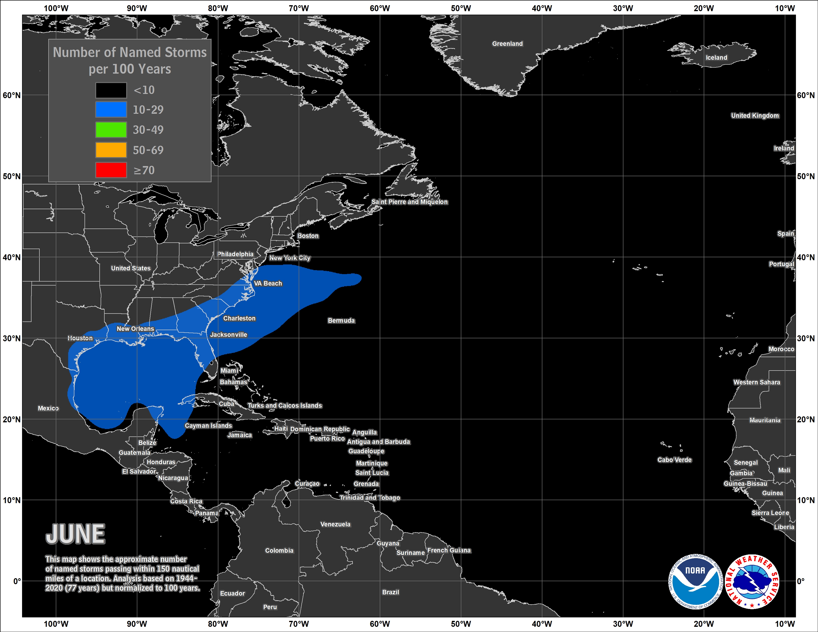
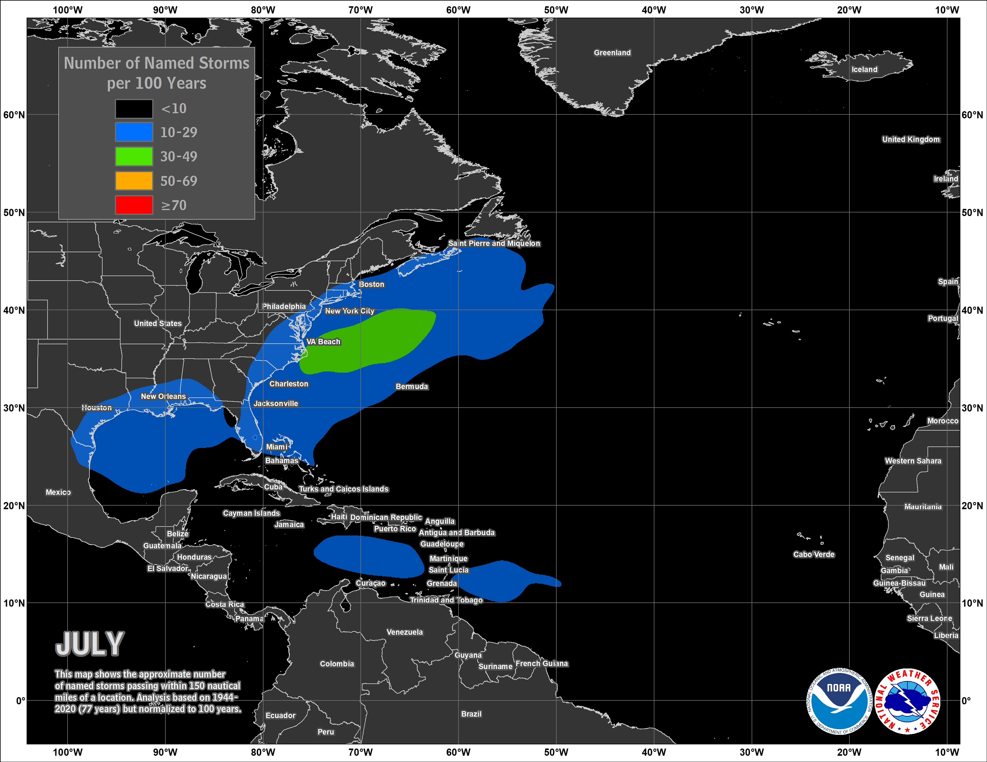
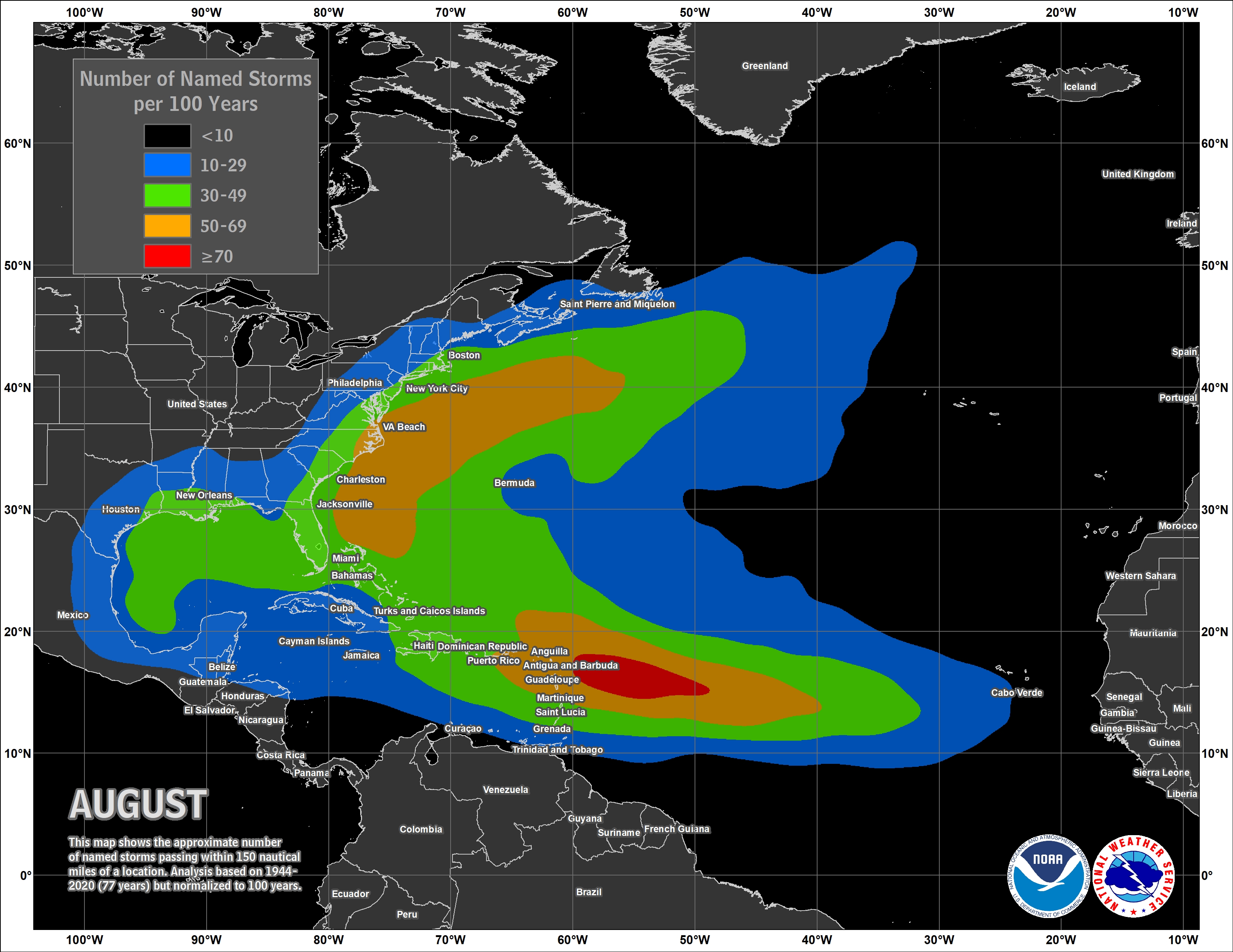
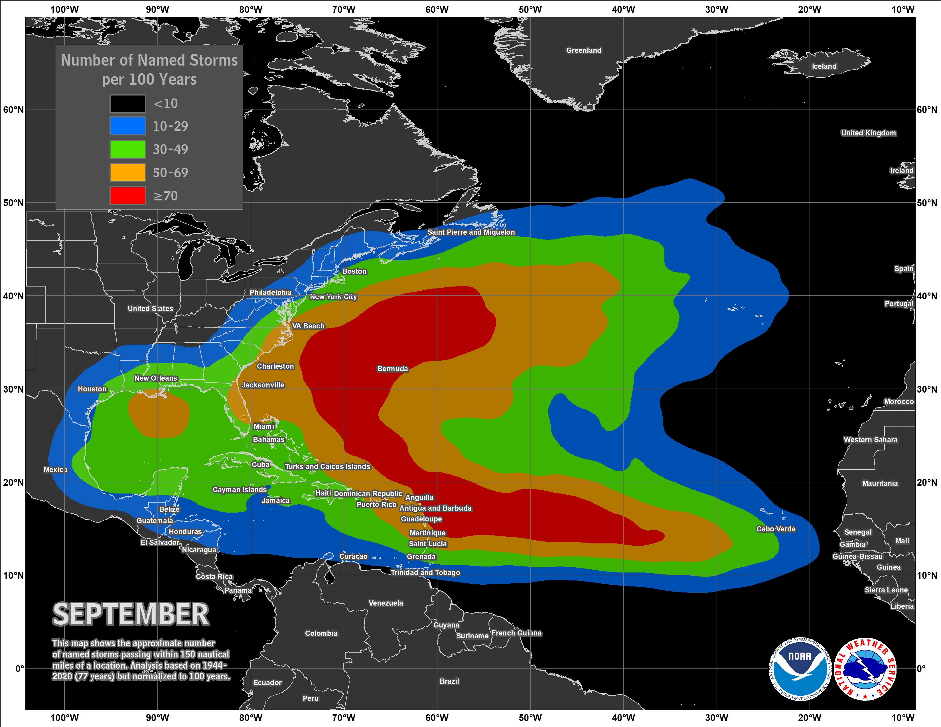
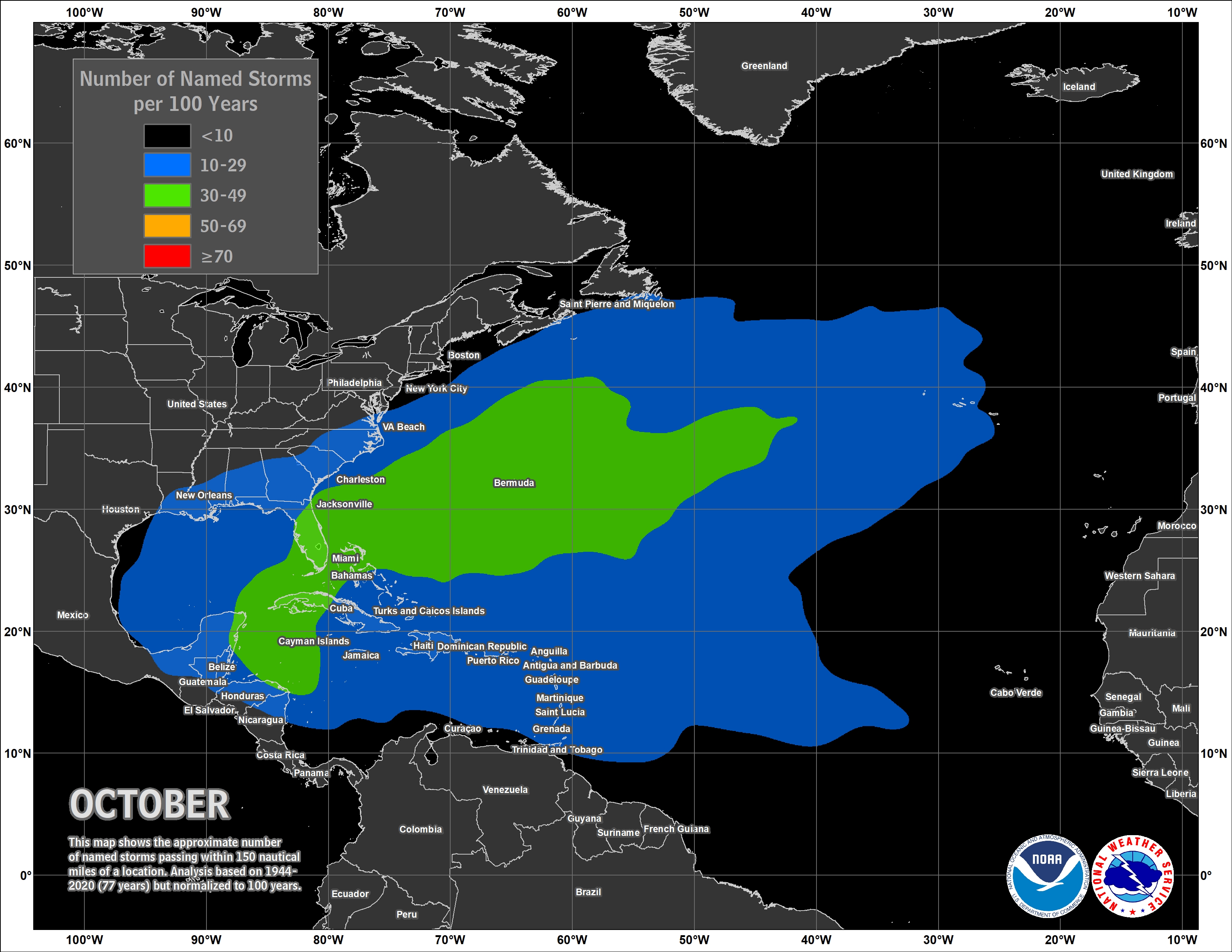
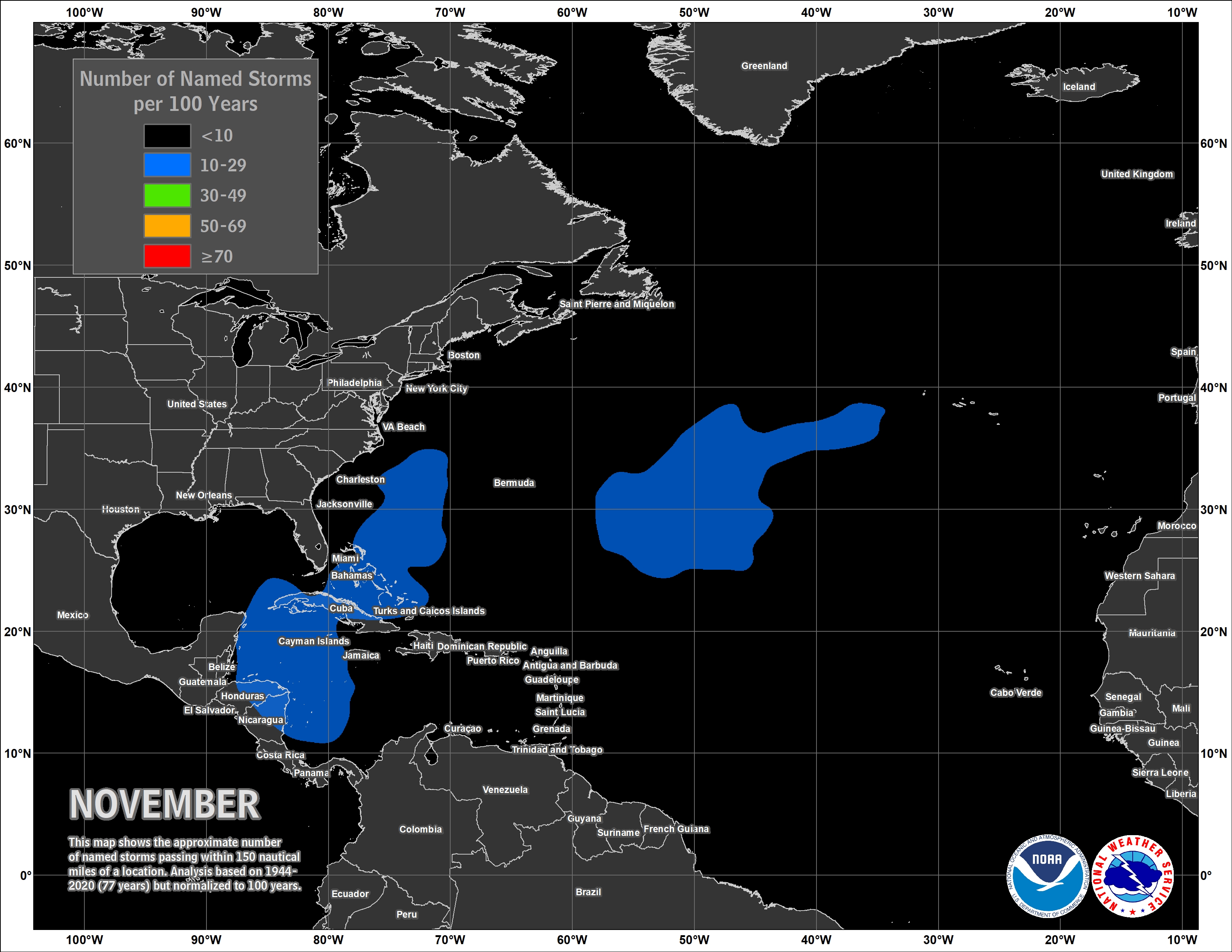
If you live along the East Coast of Gulf Coast keeps these maps in mind as you follow the weather forecasts all summer long.


