Things are still looking generally calm over the next few days while we keep eyes on the tropics. Invest 92L is still tabbed to lift north starting Thursday and across the Gulf Coast region late Friday, Saturday and through Sunday.
As it moves through, the main concern will be the rainfall. The Weather Prediction Center released and update forecast for rain totals and it is a bit higher for a slight bigger chunk of southeast Louisiana, for South Mississippi and Lower Alabama.
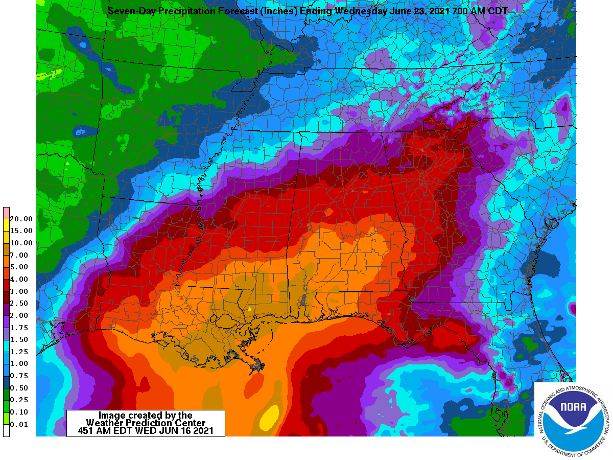
Because of the bump in rainfall totals acros a slihgtly wider area, I’ve bumped up the Tropical Threat Index.

The extra rainfall puts it at a “4” on the 1-10 scale. This is above Tropical Storm Cristobal last year and the same number as Hurricane Zeta.
For more information on the Tropical Threat Index, check this out
This doesn’t mean the storm will be “as bad” as Hurricane Zeta or “worse than” Tropical Storm Cristobal for everyone. Not does this mean this system will be “like” those storms. Cristobal was flooding/surge and Zeta was a wind producer.
At the moment, Invest 92L’s threats look to be flooding. And flooding only. But enough of a flooding threat that – generally – the level of impact it will have on the area is forecast to be the same or greater than Cristobal and Zeta.
Day-to-Day forecast
Today
Passing clouds but mostly sunny. Not as humid. Highs in the lower 90s.
Tonight
Mostly clear with some fog possible. Lows in the mid 60s.
Thursday
Some fair-weather cumulus clouds. But otherwise, mostly sunny. Highs in the lower 90s.
Thursday Night
Partly cloudy. Lows in the upper 60s.
Friday
Increasing clouds with a chance for showers and storms by afternoon and evening. Highs in the upper 80s. The chance of rain 40-percent. Rainfall totals up to 1″
…Invest 92L influence begins
Friday Night
Mostly cloudy with passing showers and storms.. Lows in the lower 70s. The chance of rain 40-percent.
Saturday
Mostly cloudy with off-and-on showers and storms likely. Highs in the lower 80s. The chance of rain 70-percent. Rainfall totals up to 3″
Saturday Night
Off-and-on showers and storms likely. Lows in the lower 70s. The chance of rain 70-percent. Rainfall totals overnight up to 3″
Sunday
Showers and storms likely. Highs in the lower 80s. The chance of rain 70 percent.
Sunday Night
Showers and storms coming to an end. Lows in the lower 70s. The chance of rain 50-percent.
…Invest 92L influence ends
Monday
Partly cloudy with chance of showers and thunderstorms. Highs in the upper 80s. The chance of rain 40-percent.
Monday Night
A few lingering showers through midnight, otherwise partly cloudy. Lows around 70.
Tuesday
Summertime storms possible. Partly cloudy. Highs in the upper 80s. The chance of rain 40-percent.


Glad I left my canoe handy!