Thundersleet has rumbled across South Mississippi recently, so I thought I would take some time to breakdown just how Thundersleet, and Thundersnow, too, are a thing!
But first, we have to go back to school!
So… Let’s start by looking at some Skew-Ts. This will help us realize how similar the atmosphere is in a situation where thundersleet is occurring versus where a regular thunderstorm is occurring.
For more info on how to read a Skew-T chart, check this out!
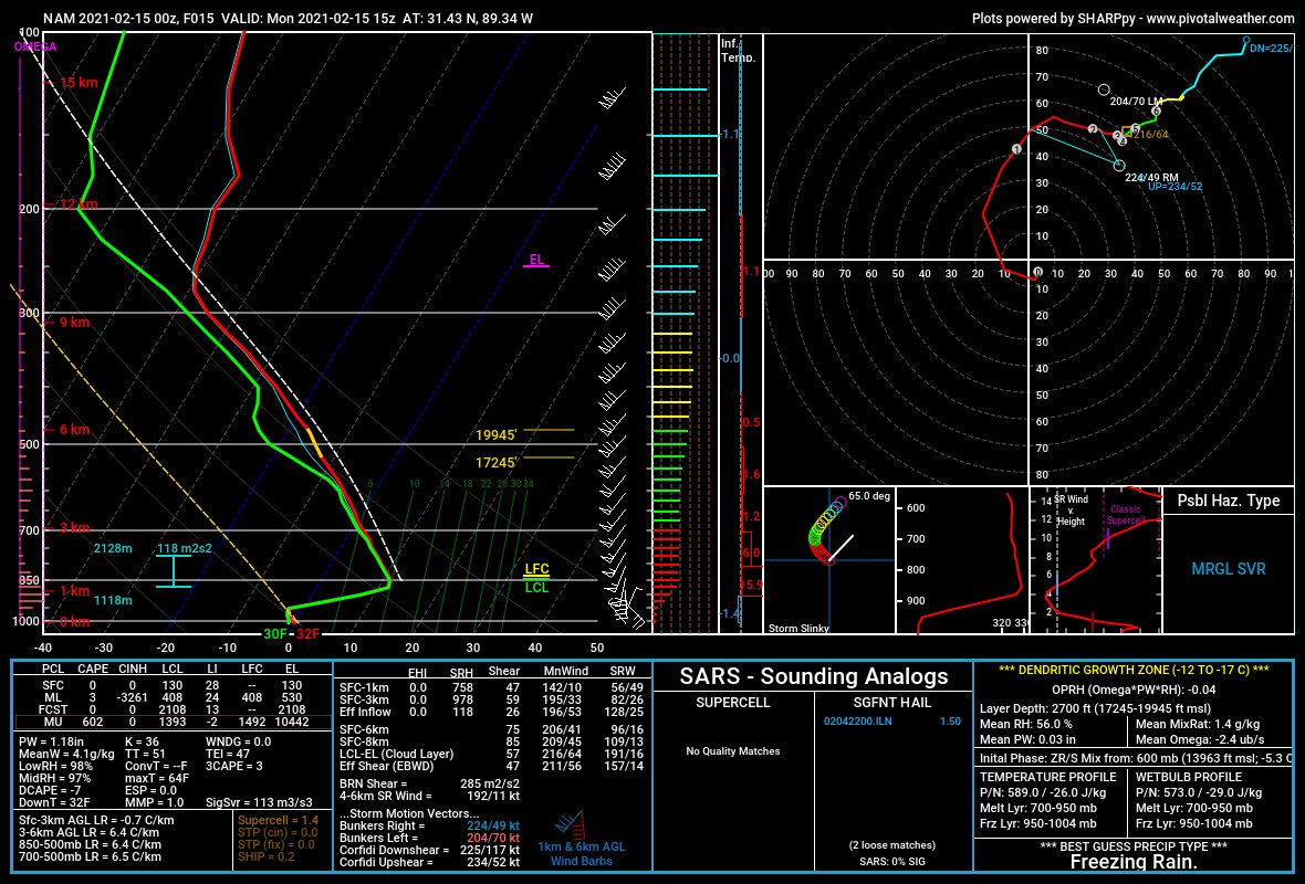
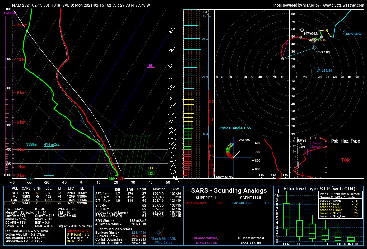
Take a look at the two Skew-Ts above. Don’t worry about all of the extra numbers and plots. Just take a look at the line-graph-looking chart in the upper left on each Skew-T. One graph (on the left) is from South Mississippi during a time when sleet was falling and thunder was heard rumbling. The other graph (on the right) is from a time when thunderstorms were moving through the Gulf.
The two graphs are pretty similar. The green and red lines are pretty close to following the same path – except toward the bottom. On one, the two lines jet back to the left, and on the other, they just continue downward.
That is an indication that – mathematically – through most of the atmosphere, you would not be able to distinguish between thundersleet and regular a thunderstorm. The only different shows up as you get toward the bottom (closer to the ground)
Both feature similar temperatures decreasing with height and some sort of saturation. But how does it thunder when it is that cold?
How does thunder happen?
Thunder happens when the air around a lightning bolt expands, so quickly, that it makes a sound as all of the air molecules bump into one another.
A lightning bolt happens when the electrical charge inside of a cloud discharges – a lot like the static electricity shock you feel after you scuff your feet on the carpet on a cold winter day and reach out and grab something metal.
But, how does a cloud build up an electrical charge?
Great question.
This often happens inside of a thunderstorm due to a process called differentiation. No, not like Calculus. This is more like the geological version of the word. It turns out that parts of a cloud can contain different-sized water droplets. Toward the bottom of the cloud, the bigger and heavier rain drops collect. And toward the top of the clouds there are smaller and lighter raindrops. It is the same story with hail, too. Small hail up top, larger hail toward the bottom.
But that differentiation isn’t even across the cloud. And it isn’t equal, either.
That is because the raindrops and hail toward the top of the cloud are being lifted toward the top of the cloud by an updraft. An updraft is a rapidly rising column of air. And there can be multiple updrafts within a single thunderstorm. And different updrafts can have different strengths, and can – thus – lift different-sized of raindrops and hail differently!
This makes the inside of the cloud a pretty turbulent place (hint: this is why planes don’t fly through storms! And one reason why flying through big clouds can cause turbulence!). And it means that there are a lot of rain drops and hail stones bumping into each other. Constantly!
Amid all the chaos and turbulence one piece of “order” does take place: This process, for both hailstones and rain drops, means that one area of the cloud has a different charge than other areas of the cloud. And when the potential energy reaches a certain threshold – FLASH! – you get a lightning bolt.
Sleet is winter weather, though! Storms are in the Spring and Summer! What gives?!
The updrafts in a thunderstorm during the Spring and Summer can also exist within storms in the Winter, too! Because an updraft is simply where air starts to ride rapidly. And that happens when warm air is under cold air.
The ‘bottom’ of an updraft, where the air starts to rise quickly, can start almost anywhere. An updraft can start just off the surface (we call this a “surface-based” storm), or can start higher up in the cloud (we call these “elevated” storms).
Let’s got back to our example from above….
If we started an updraft at 850mb, the first horizontal white line up from the bottom on each chart, and ended the updraft at 500mb, the third horizontal white line up from the bottom, lets look at what the temperature difference would be….
On the Skew-T on the left, the air would rise up moving from a temperature of 11 degrees Celsius to a temperature of -14 degrees Celsius. A difference of 25 degrees Celsius.
On the Skew-T on the right, the air would rise up moving from a temperature of 13 degrees Celsius to a temperature of -12 degrees Celsius. A difference of 25 degrees Celsius.
Updrafts, and their relative strength, are often determined by how much instability there is within the atmosphere. That is a fancy way of saying is there a lot of warmer air sitting underneath a lot of colder air. This is because warm air rises.
The stronger the gradient there is between warm and cold air, the faster that warm air wants to rise – no matter where it starts.
In the case of our two Skew-Ts, though, that gradient was the same. Meaning that thundersleet, is using the same physics – in a similar strength – as a thunderstorm. Meaning it can differentiate things inside of the cloud in a similar manner. Meaning it can build up an electrical charge in a similar way.
Meaning it can discharge that charge creating lightning! And thus creating thunder! While sleeting!
Thundersleet.


One thought on “Wx Info: Thundersleet?! What is Thundersleet??”
Comments are closed.