Things continue to ramp up this morning. Rain is falling across most of the area, it is mixed with sleet across some of the western counties, and to the north (but still south of I-20, freezing rain has started to glaze over roads and bridges.
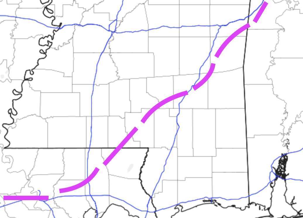
That is a look at the line between freezing things and non-freezing things as of 8:30am. To the west things are starting to freeze and to the east things are still (barely) liquid.
Forecasts by area
Here is a breakdown of the forecasts by County for Monday:
Northern counties
Simpson County
10am – Freezing rain continues
1pm – Sleet showers coming to an end
4pm – Drying out, lingering light ice crystal flurries possible
7pm – Precipitation has ended, very cold air filters in with overnight lows below 20 degrees
Smith County
10am – Freezing rain continues
1pm – Sleet showers coming to an end
4pm – Drying out, lingering light ice crystal flurries possible
7pm – Precipitation has ended, very cold air filters in with overnight lows below 20 degrees
Jasper County
10am – Freezing rain continues
1pm – Sleet showers coming to an end
4pm – Drying out, lingering light ice crystal flurries possible
7pm – Precipitation has ended, very cold air filters in with overnight lows below 20 degrees
Clarke County
10am – Freezing rain continues
1pm – Sleet showers coming to an end
4pm – Some light ice crystal flurries possible
7pm – Precipitation has ended, very cold air filters in with overnight lows below 20 degrees
HWY 84 Corridor
Lawrence County
10am – Freezing rain continues
1pm – Sleet and ice crystal showers coming to an end
4pm – Drying out, lingering light ice crystal flurries possible
7pm – Precipitation has ended, very cold air filters in with overnight lows below 20 degrees
Jefferson Davis County
10am – Freezing rain continues
1pm – Sleet showers coming to an end
4pm – Drying out, lingering light ice crystal flurries possible
7pm – Precipitation has ended, very cold air filters in with overnight lows below 20 degrees
Covington County
10am – Freezing rain continues to fall
1pm – Freezing rain showers coming to an end
4pm – Drying out, lingering light ice crystal flurries possible
7pm – Precipitation has ended, very cold air filters in with overnight lows around 20 degrees
Jones County
10am – Freezing rain continues to fall
1pm – Freezing rain showers coming to an end
4pm – Drying out, lingering light ice crystal flurries possible
7pm – Precipitation has ended, very cold air filters in with overnight lows around 20 degrees
Wayne County
10am – Rain, that quickly changes to freezing rain, continues to fall
1pm – Freezing rain showers coming to an end
4pm – Some lingering sleet possible
7pm – Precipitation has ended, very cold air filters in with overnight lows around 20 degrees
HWY 98 Corridor
Walthall County
10am – Freezing rain and sleet continues
1pm – Sleet and ice crystal showers coming to an end
4pm – Drying out, lingering light ice crystal flurries possible
7pm – Precipitation has ended, very cold air filters in with overnight lows around 20 degrees
Marion County
10am – Freezing rain and sleet continues
1pm – Sleet and ice crystal showers coming to an end
4pm – Drying out, lingering light ice crystal flurries possible
7pm – Precipitation has ended, very cold air filters in with overnight lows around 20 degrees
Lamar County
10am – Rain, changes to freezing rain, continues to fall
1pm – Freezing rain showers coming to an end
4pm – Drying out, lingering light ice crystal flurries possible
7pm – Precipitation has ended, very cold air filters in with overnight lows around 20 degrees
Forrest County
10am – Rain, changes to freezing rain, continues to fall
1pm – Freezing rain showers coming to an end
4pm – Drying out, lingering light ice crystal flurries possible
7pm – Precipitation has ended, very cold air filters in with overnight lows around 20 degrees
Perry County
10am – Rain, that quickly changes to freezing rain, continues to fall
1pm – Freezing rain showers coming to an end
4pm – Drying out, lingering light ice crystal flurries possible
7pm – Precipitation has ended, very cold air filters in with overnight lows around 20 degrees
Greene County
10am – Rain, that quickly changes to freezing rain, continues to fall
1pm – Freezing rain showers coming to an end
4pm – Some lingering sleet possible
7pm – Precipitation has ended, very cold air filters in with overnight lows around 20 degrees
HWY 26 Corridor
Pearl River County
10am – Cold rain continues to fall
1pm – Freezing rain showers coming to an end
4pm – Drying out, lingering light ice crystal flurries possible
7pm – Precipitation has ended, very cold air filters in with overnight lows around 20 degrees
Stone County
10am – Cold rain continues to fall
1pm – Freezing rain showers coming to an end
4pm – Drying out, lingering light ice crystal flurries possible
7pm – Precipitation has ended, very cold air filters in with overnight lows around 20 degrees
George County
10am – Cold rain continues to fall
1pm – Rain showers coming to an end
4pm – Some light sleet possible
7pm – Precipitation has ended, very cold air filters in with overnight lows around 20 degrees
The Bottom Line
Not much has changed here.
Be prepared for the potential for wintry precipitation, followed by some pretty cold air. Travel will be difficult Monday before noon. Places will be impassable by Monday afternoon – especially north. And, for some places, it will be almost impossible to drive anywhere overnight Monday and into Tuesday morning.
The good news is that by Tuesday afternoon, things will start to melt and temperatures will be above freezing – barely. And you may be able to get some places. Folks in rurl areas and along county roads that are well shaded will likely still be stuck.
The bad news is that anything that doesn’t evaporate, will likely re-freeze overnight Tuesday and into Wednesday morning. That means another game of “be somewhere by Tuesday at sundown that you are comfortable being until Wednesday at noon.”
But by Wednesday afternoon, we will be back above freezing for a while. And life will get back to normal.


