Okay, boy do we have a doozy of an event coming up tomorrow and into Wednesday morning. There are a lot of moving parts and different things to watch for and I will do my best to line it all up and explain it all in this post.
So far the main concerns are for the wind (just regular wind), the storms, and for this whole forecast to bust (not a problem for you, other than nothing actually happening).

On the handy bar chart above, notice that the concern on Tuesday afternoon is mainly the regular ole wind. That shifts to storms overnight, but notice that orange bar of wind remains prevalent all night and into tomorrow morning.
The chances for things ‘busting’ is highest Tuesday evening before midnight and eases off pretty dramatically after midnight. That means that once we get later and later into the evening, the chances that storms don’t develop and severe weather doesn’t occur gets lower (meaning we are more confident is storms the later into the overnight hours we go).
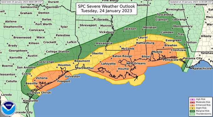
Because of the storm threat, the SPC is holding an Enhanced Risk for severe weather. That is a “3” on the 1-to-5 scale, where “5” is the highest risk for the most significant severe weather.
SOME DATA
The wind tomorrow and into Wednesday is the biggest slam dunk. In fact, I would almost treat this like a weak landfalling tropical storm. Here is a look at some of the wind gusts possible shortly after sundown. These wind gust speeds will likely hold through midnight for most spots.
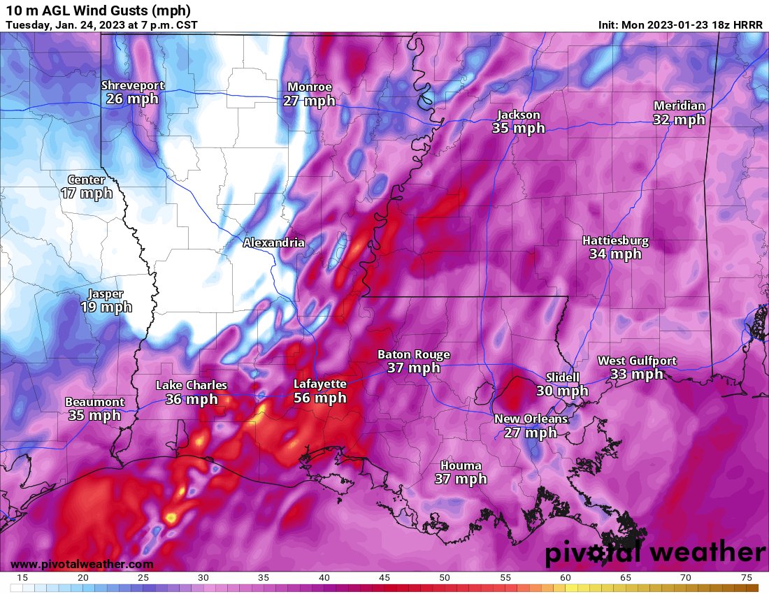
This will lead to power outages in some places. And I would expect many trees to fall, too. So, I would make sure you are prepared to be without power for up to 12 hours. I don’t think a ton of people will be without power for that long, but just in case it is you, I would prepare for that.
On top of that wind, there is the potential for storms.
The interesting part of the forecast is the split in the CIPS Analogs guidance which shows that historically there is a 1-in-3 shot that no severe weather happens at all. And about a 1-in-3 chance that there is at least one significant severe weather event. And another 1-in-3 chance that there are storms and a few severe reports but nothing too crazy.

It isn’t often that evenly split.
The grades for all of those analogs run between a C and a B-, so it isn’t like any one of those is a total slam dunk relative to another.
The model guidance isn’t so sure surface-based severe weather ever develops at all. The latest HRRR guidance shows an inversion in place in the lower levels which would limit the tornado and wind gust threat while holding a threat for small hail.
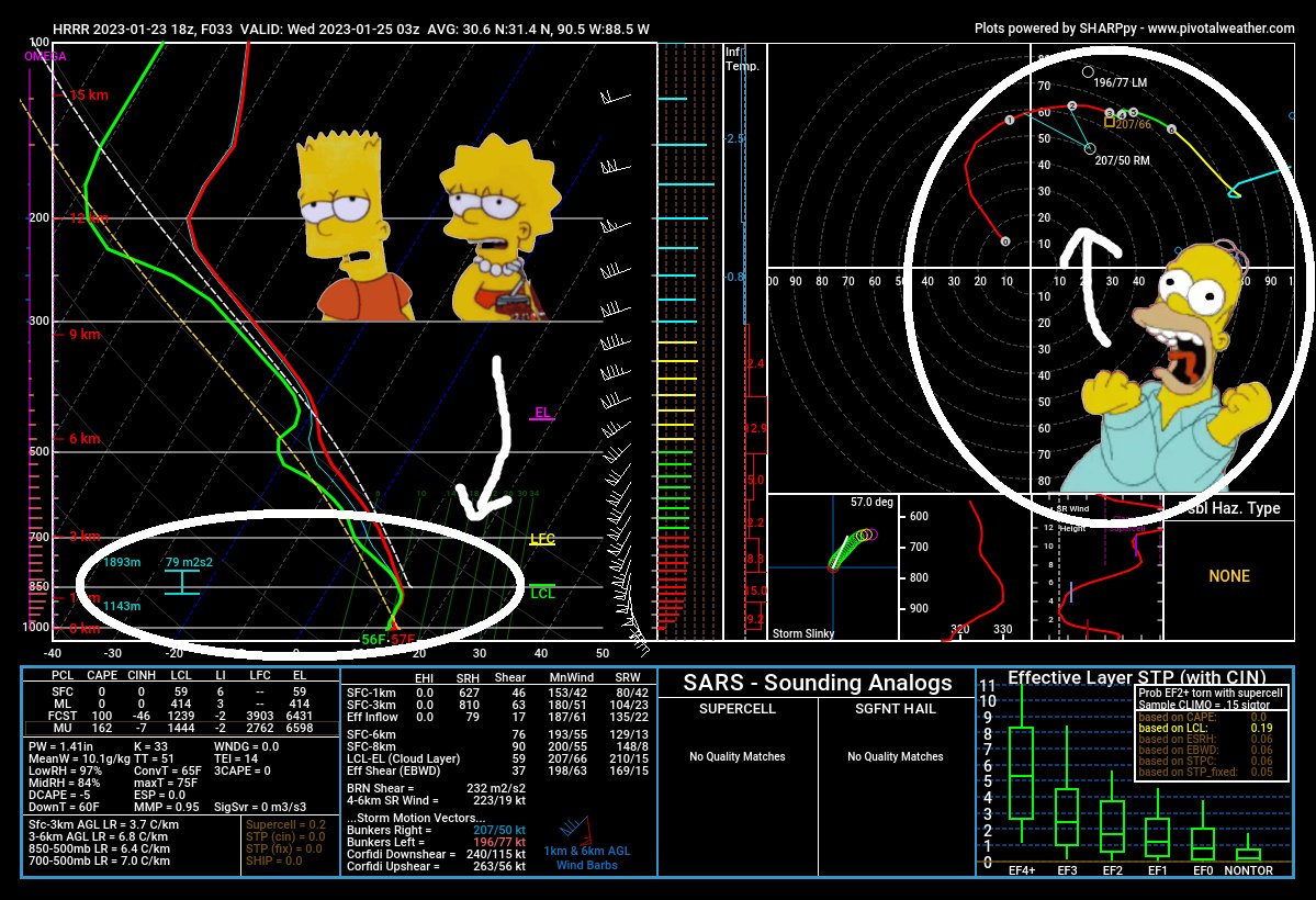
That means that while Homer can scream with terror at the hodograph, it is meaningless with respect to developing and sustaining tornadoes because they can’t get through the inversion and down to the surface.
So there is a lot to watch and a lot to monitor for your local meteorologists. And for you, a lot to consider when making your plans for tomorrow.
Know that the wind will be pretty strong and gusty at times, particularly in the afternoon. Know that storms will be possible in the evening and through the overnight hours. And don’t be surprised if you are never under a warning, because the strongest storms may not clip the “severe criteria” due to missing some of the atmospheric parameters.
COUNTY-BY-COUNTY TIMELINE & THREATS
A quick reminder that this timeline is the first best estimate, based on the latest available data, .There may be some changes during the coming 36 to 48 hours.
Louisiana
St. Helena Parish
Tuesday 1p – 7p — Mostly cloudy with a strong southerly breeze. Sustained wind between 15mph and 30mph with gusts up to 50mph possible. Isolated storms also possible. Some storms will be strong, very few will be severe. Main concern will be brief heavy rain and gusty wind.
Tuesday 7p – Wednesday 1a — Cold front passes with showers and storms ahead of and along the front. Some storms may be severe, especially near and south of I-10 / I-12. Main concerns are brief heavy rain, lightning, wind gusts up to 70mph, small hail and a few tornadoes up to EF-3 in strength.
Wednesday 1a – 7a — Storms ending, wind continues from the west at 10mph to 20mph with gusts up to 35mph.
Tangipahoa Parish
Tuesday 1p – 7p — Mostly cloudy with a strong southerly breeze. Sustained wind between 15mph and 30mph with gusts up to 50mph possible. Isolated storms also possible. Some storms will be strong, very few will be severe. Main concern will be brief heavy rain and gusty wind.
Tuesday 7p – Wednesday 1a — Cold front passes with showers and storms ahead of and along the front. Some storms may be severe, especially near and south of I-10 / I-12. Main concerns are brief heavy rain, lightning, wind gusts up to 70mph, small hail and a few tornadoes up to EF-3 in strength.
Wednesday 1a – 7a — Storms ending, wind continues from the west at 10mph to 20mph with gusts up to 35mph.
Livingston Parish
Tuesday 1p – 7p — Mostly cloudy with a strong southerly breeze. Sustained wind between 15mph and 30mph with gusts up to 50mph possible. Isolated storms also possible. Some storms will be strong, very few will be severe. Main concern will be brief heavy rain and gusty wind.
Tuesday 7p – Wednesday 1a — Cold front passes with showers and storms ahead of and along the front. Some storms may be severe, especially near and south of I-10 / I-12. Main concerns are brief heavy rain, lightning, wind gusts up to 70mph, small hail and a few tornadoes up to EF-3 in strength.
Wednesday 1a – 7a — Storms ending, wind continues from the west at 10mph to 20mph with gusts up to 35mph.
Washington Parish
Tuesday 2p – 8p — Mostly cloudy with a strong southerly breeze. Sustained wind between 15mph and 30mph with gusts up to 50mph possible. Isolated storms also possible. Some storms will be strong, very few will be severe. Main concern will be brief heavy rain and gusty wind.
Tuesday 8p – Wednesday 2a — Cold front passes with showers and storms ahead of and along the front. Some storms may be severe, especially near and south of I-10 / I-12. Main concerns are brief heavy rain, lightning, wind gusts up to 70mph, small hail and a few tornadoes up to EF-3 in strength.
Wednesday 2a – 8a — Storms ending, wind continues from the west at 10mph to 20mph with gusts up to 35mph.
St. Tammany Parish
Tuesday 2p – 8p — Mostly cloudy with a strong southerly breeze. Sustained wind between 15mph and 30mph with gusts up to 50mph possible. Isolated storms also possible. Some storms will be strong, very few will be severe. Main concern will be brief heavy rain and gusty wind.
Tuesday 8p – Wednesday 2a — Cold front passes with showers and storms ahead of and along the front. Some storms may be severe, especially near and south of I-10 / I-12. Main concerns are brief heavy rain, lightning, wind gusts up to 70mph, small hail and a few tornadoes up to EF-3 in strength.
Wednesday 2a – 8a — Storms ending, wind continues from the west at 10mph to 20mph with gusts up to 35mph.
Mississippi
NEAR I-20
Copiah County
Tuesday 1p – 7p — Mostly cloudy with a strong southerly breeze. Sustained wind between 15mph and 30mph with gusts up to 50mph possible. Isolated storms also possible. Some storms will be strong, very few will be severe. Main concern will be brief heavy rain and gusty wind.
Tuesday 7p – Wednesday 1a — Cold front passes with showers and storms ahead of and along the front. Some storms may be strong to marginally severe. Main concerns are brief heavy rain, lightning, wind gusts up to 70mph, small hail and a few brief tornadoes up to EF-2 in strength.
Wednesday 1a – 7a — Storms ending, wind continues from the west at 10mph to 20mph with gusts up to 35mph.
Simpson County
Tuesday 1p – 7p — Mostly cloudy with a strong southerly breeze. Sustained wind between 15mph and 30mph with gusts up to 50mph possible. Isolated storms also possible. Some storms will be strong, very few will be severe. Main concern will be brief heavy rain and gusty wind.
Tuesday 7p – Wednesday 1a — Cold front passes with showers and storms ahead of and along the front. Some storms may be strong to marginally severe. Main concerns are brief heavy rain, lightning, wind gusts up to 70mph, small hail and a few brief tornadoes up to EF-2 in strength.
Wednesday 1a – 7a — Storms ending, wind continues from the west at 10mph to 20mph with gusts up to 35mph.
Smith County
Tuesday 2p – 8p — Mostly cloudy with a strong southerly breeze. Sustained wind between 15mph and 30mph with gusts up to 50mph possible. Isolated storms also possible. Some storms will be strong, very few will be severe. Main concern will be brief heavy rain and gusty wind.
Tuesday 8p – Wednesday 2a — Cold front passes with showers and storms ahead of and along the front. Some storms may be strong to marginally severe. Main concerns are brief heavy rain, lightning, wind gusts up to 70mph, small hail and a few brief tornadoes up to EF-2 in strength.
Wednesday 2a – 8a — Storms ending, wind continues from the west at 10mph to 20mph with gusts up to 35mph.
Scott County
Tuesday 2p – 8p — Mostly cloudy with a strong southerly breeze. Sustained wind between 15mph and 30mph with gusts up to 50mph possible. Isolated storms also possible. Some storms will be strong, very few will be severe. Main concern will be brief heavy rain and gusty wind.
Tuesday 8p – Wednesday 2a — Cold front passes with showers and storms ahead of and along the front. Some storms may be strong to marginally severe. Main concerns are brief heavy rain, lightning, wind gusts up to 70mph, small hail and a few brief tornadoes up to EF-2 in strength.
Wednesday 2a – 8a — Storms ending, wind continues from the west at 10mph to 20mph with gusts up to 35mph.
Jasper County
Tuesday 2p – 8p — Mostly cloudy with a strong southerly breeze. Sustained wind between 15mph and 30mph with gusts up to 50mph possible. Isolated storms also possible. Some storms will be strong, very few will be severe. Main concern will be brief heavy rain and gusty wind.
Tuesday 8p – Wednesday 2a — Cold front passes with showers and storms ahead of and along the front. Some storms may be strong to marginally severe. Main concerns are brief heavy rain, lightning, wind gusts up to 70mph, small hail and a few brief tornadoes up to EF-2 in strength.
Wednesday 2a – 8a — Storms ending, wind continues from the west at 10mph to 20mph with gusts up to 35mph.
Newton County
Tuesday 2p – 8p — Mostly cloudy with a strong southerly breeze. Sustained wind between 15mph and 30mph with gusts up to 50mph possible. Isolated storms also possible. Some storms will be strong, very few will be severe. Main concern will be brief heavy rain and gusty wind.
Tuesday 8p – Wednesday 2a — Cold front passes with showers and storms ahead of and along the front. Some storms may be strong to marginally severe. Main concerns are brief heavy rain, lightning, wind gusts up to 70mph, small hail and a few brief tornadoes up to EF-2 in strength.
Wednesday 2a – 8a — Storms ending, wind continues from the west at 10mph to 20mph with gusts up to 35mph.
Clarke County
Tuesday 3p – 9p — Mostly cloudy with a strong southerly breeze. Sustained wind between 15mph and 30mph with gusts up to 50mph possible. Isolated storms also possible. Some storms will be strong, very few will be severe. Main concern will be brief heavy rain and gusty wind.
Tuesday 9p – Wednesday 3a — Cold front passes with showers and storms ahead of and along the front. Some storms may be strong to marginally severe. Main concerns are brief heavy rain, lightning, wind gusts up to 70mph, small hail and a few brief tornadoes up to EF-2 in strength.
Wednesday 3a – 9a — Storms ending, wind continues from the west at 10mph to 20mph with gusts up to 35mph.
Lauderdale County
Tuesday 3p – 9p — Mostly cloudy with a strong southerly breeze. Sustained wind between 15mph and 30mph with gusts up to 50mph possible. Isolated storms also possible. Some storms will be strong, very few will be severe. Main concern will be brief heavy rain and gusty wind.
Tuesday 9p – Wednesday 3a — Cold front passes with showers and storms ahead of and along the front. Some storms may be strong to marginally severe. Main concerns are brief heavy rain, lightning, wind gusts up to 70mph, small hail and a few brief tornadoes up to EF-2 in strength.
Wednesday 3a – 9a — Storms ending, wind continues from the west at 10mph to 20mph with gusts up to 35mph.
HIGHWAY 84 CORRIDOR
Lincoln County
Tuesday 1p – 7p — Mostly cloudy with a strong southerly breeze. Sustained wind between 15mph and 30mph with gusts up to 50mph possible. Isolated storms also possible. Some storms will be strong, very few will be severe. Main concern will be brief heavy rain and gusty wind.
Tuesday 7p – Wednesday 1a — Cold front passes with showers and storms ahead of and along the front. Some storms may be strong to marginally severe. Main concerns are brief heavy rain, lightning, wind gusts up to 70mph, small hail and a few brief tornadoes up to EF-2 in strength.
Wednesday 1a – 7a — Storms ending, wind continues from the west at 10mph to 20mph with gusts up to 35mph.
Lawrence County
Tuesday 1p – 7p — Mostly cloudy with a strong southerly breeze. Sustained wind between 15mph and 30mph with gusts up to 50mph possible. Isolated storms also possible. Some storms will be strong, very few will be severe. Main concern will be brief heavy rain and gusty wind.
Tuesday 7p – Wednesday 1a — Cold front passes with showers and storms ahead of and along the front. Some storms may be strong to marginally severe. Main concerns are brief heavy rain, lightning, wind gusts up to 70mph, small hail and a few brief tornadoes up to EF-2 in strength.
Wednesday 1a – 7a — Storms ending, wind continues from the west at 10mph to 20mph with gusts up to 35mph.
Jeff Davis County
Tuesday 2p – 8p — Mostly cloudy with a strong southerly breeze. Sustained wind between 15mph and 30mph with gusts up to 50mph possible. Isolated storms also possible. Some storms will be strong, very few will be severe. Main concern will be brief heavy rain and gusty wind.
Tuesday 8p – Wednesday 2a — Cold front passes with showers and storms ahead of and along the front. Some storms may be strong to marginally severe. Main concerns are brief heavy rain, lightning, wind gusts up to 70mph, small hail and a few brief tornadoes up to EF-2 in strength.
Wednesday 2a – 8a — Storms ending, wind continues from the west at 10mph to 20mph with gusts up to 35mph.
Covington County
Tuesday 2p – 8p — Mostly cloudy with a strong southerly breeze. Sustained wind between 15mph and 30mph with gusts up to 50mph possible. Isolated storms also possible. Some storms will be strong, very few will be severe. Main concern will be brief heavy rain and gusty wind.
Tuesday 8p – Wednesday 2a — Cold front passes with showers and storms ahead of and along the front. Some storms may be strong to marginally severe. Main concerns are brief heavy rain, lightning, wind gusts up to 70mph, small hail and a few brief tornadoes up to EF-2 in strength.
Wednesday 2a – 8a — Storms ending, wind continues from the west at 10mph to 20mph with gusts up to 35mph.
Jones County
Tuesday 2p – 8p — Mostly cloudy with a strong southerly breeze. Sustained wind between 15mph and 30mph with gusts up to 50mph possible. Isolated storms also possible. Some storms will be strong, very few will be severe. Main concern will be brief heavy rain and gusty wind.
Tuesday 8p – Wednesday 2a — Cold front passes with showers and storms ahead of and along the front. Some storms may be strong to marginally severe. Main concerns are brief heavy rain, lightning, wind gusts up to 70mph, small hail and a few brief tornadoes up to EF-2 in strength.
Wednesday 2a – 8a — Storms ending, wind continues from the west at 10mph to 20mph with gusts up to 35mph.
Wayne County
Tuesday 3p – 9p — Mostly cloudy with a strong southerly breeze. Sustained wind between 15mph and 30mph with gusts up to 50mph possible. Isolated storms also possible. Some storms will be strong, very few will be severe. Main concern will be brief heavy rain and gusty wind.
Tuesday 9p – Wednesday 3a — Cold front passes with showers and storms ahead of and along the front. Some storms may be strong to marginally severe. Main concerns are brief heavy rain, lightning, wind gusts up to 70mph, small hail and a few brief tornadoes up to EF-2 in strength.
Wednesday 3a – 9a — Storms ending, wind continues from the west at 10mph to 20mph with gusts up to 35mph.
HIGHWAY 98 CORRIDOR
Pike County
Tuesday 1p – 7p — Mostly cloudy with a strong southerly breeze. Sustained wind between 15mph and 30mph with gusts up to 50mph possible. Isolated storms also possible. Some storms will be strong, very few will be severe. Main concern will be brief heavy rain and gusty wind.
Tuesday 7p – Wednesday 1a — Cold front passes with showers and storms ahead of and along the front. Some storms may be strong to marginally severe. Main concerns are brief heavy rain, lightning, wind gusts up to 70mph, small hail and a few tornadoes up to EF-3 in strength.
Wednesday 1a – 7a — Storms ending, wind continues from the west at 10mph to 20mph with gusts up to 35mph.
Walthall County
Tuesday 1p – 7p — Mostly cloudy with a strong southerly breeze. Sustained wind between 15mph and 30mph with gusts up to 50mph possible. Isolated storms also possible. Some storms will be strong, very few will be severe. Main concern will be brief heavy rain and gusty wind.
Tuesday 7p – Wednesday 1a — Cold front passes with showers and storms ahead of and along the front. Some storms may be strong to marginally severe. Main concerns are brief heavy rain, lightning, wind gusts up to 70mph, small hail and a few tornadoes up to EF-3 in strength.
Wednesday 1a – 7a — Storms ending, wind continues from the west at 10mph to 20mph with gusts up to 35mph.
Marion County
Tuesday 2p – 8p — Mostly cloudy with a strong southerly breeze. Sustained wind between 15mph and 30mph with gusts up to 50mph possible. Isolated storms also possible. Some storms will be strong, very few will be severe. Main concern will be brief heavy rain and gusty wind.
Tuesday 8p – Wednesday 2a — Cold front passes with showers and storms ahead of and along the front. Some storms may be strong to marginally severe. Main concerns are brief heavy rain, lightning, wind gusts up to 70mph, small hail and a few tornadoes up to EF-3 in strength.
Wednesday 2a – 8a — Storms ending, wind continues from the west at 10mph to 20mph with gusts up to 35mph.
Lamar County
Tuesday 2p – 8p — Mostly cloudy with a strong southerly breeze. Sustained wind between 15mph and 30mph with gusts up to 50mph possible. Isolated storms also possible. Some storms will be strong, very few will be severe. Main concern will be brief heavy rain and gusty wind.
Tuesday 8p – Wednesday 2a — Cold front passes with showers and storms ahead of and along the front. Some storms may be strong to marginally severe. Main concerns are brief heavy rain, lightning, wind gusts up to 70mph, small hail and a few tornadoes up to EF-3 in strength.
Wednesday 2a – 8a — Storms ending, wind continues from the west at 10mph to 20mph with gusts up to 35mph.
Forrest County
Tuesday 2p – 8p — Mostly cloudy with a strong southerly breeze. Sustained wind between 15mph and 30mph with gusts up to 50mph possible. Isolated storms also possible. Some storms will be strong, very few will be severe. Main concern will be brief heavy rain and gusty wind.
Tuesday 8p – Wednesday 2a — Cold front passes with showers and storms ahead of and along the front. Some storms may be strong to marginally severe. Main concerns are brief heavy rain, lightning, wind gusts up to 70mph, small hail and a few tornadoes up to EF-3 in strength.
Wednesday 2a – 8a — Storms ending, wind continues from the west at 10mph to 20mph with gusts up to 35mph.
Perry County
Tuesday 3p – 9p — Mostly cloudy with a strong southerly breeze. Sustained wind between 15mph and 30mph with gusts up to 50mph possible. Isolated storms also possible. Some storms will be strong, very few will be severe. Main concern will be brief heavy rain and gusty wind.
Tuesday 9p – Wednesday 3a — Cold front passes with showers and storms ahead of and along the front. Some storms may be strong to marginally severe. Main concerns are brief heavy rain, lightning, wind gusts up to 70mph, small hail and a few tornadoes up to EF-3 in strength.
Wednesday 3a – 9a — Storms ending, wind continues from the west at 10mph to 20mph with gusts up to 35mph.
Greene County
Tuesday 3p – 9p — Mostly cloudy with a strong southerly breeze. Sustained wind between 15mph and 30mph with gusts up to 50mph possible. Isolated storms also possible. Some storms will be strong, very few will be severe. Main concern will be brief heavy rain and gusty wind.
Tuesday 9p – Wednesday 3a — Cold front passes with showers and storms ahead of and along the front. Some storms may be strong to marginally severe. Main concerns are brief heavy rain, lightning, wind gusts up to 70mph, small hail and a few tornadoes up to EF-3 in strength.
Wednesday 3a – 9a — Storms ending, wind continues from the west at 10mph to 20mph with gusts up to 35mph.
HIGHWAY 26 CORRIDOR
Pearl River County
Tuesday 2p – 8p — Mostly cloudy with a strong southerly breeze. Sustained wind between 15mph and 30mph with gusts up to 50mph possible. Isolated storms also possible. Some storms will be strong, very few will be severe. Main concern will be brief heavy rain and gusty wind.
Tuesday 8p – Wednesday 2a — Cold front passes with showers and storms ahead of and along the front. Some storms may be strong to marginally severe. Main concerns are brief heavy rain, lightning, wind gusts up to 70mph, small hail and a few tornadoes up to EF-3 in strength.
Wednesday 2a – 8a — Storms ending, wind continues from the west at 10mph to 20mph with gusts up to 35mph.
Stone County
Tuesday 2p – 8p — Mostly cloudy with a strong southerly breeze. Sustained wind between 15mph and 30mph with gusts up to 50mph possible. Isolated storms also possible. Some storms will be strong, very few will be severe. Main concern will be brief heavy rain and gusty wind.
Tuesday 8p – Wednesday 2a — Cold front passes with showers and storms ahead of and along the front. Some storms may be strong to marginally severe. Main concerns are brief heavy rain, lightning, wind gusts up to 70mph, small hail and a few tornadoes up to EF-3 in strength.
Wednesday 2a – 8a — Storms ending, wind continues from the west at 10mph to 20mph with gusts up to 35mph.
George County
Tuesday 3p – 9p — Mostly cloudy with a strong southerly breeze. Sustained wind between 15mph and 30mph with gusts up to 50mph possible. Isolated storms also possible. Some storms will be strong, very few will be severe. Main concern will be brief heavy rain and gusty wind.
Tuesday 9p – Wednesday 3a — Cold front passes with showers and storms ahead of and along the front. Some storms may be strong to marginally severe. Main concerns are brief heavy rain, lightning, wind gusts up to 70mph, small hail and a few tornadoes up to EF-3 in strength.
Wednesday 3a – 9a — Storms ending, wind continues from the west at 10mph to 20mph with gusts up to 35mph.
COASTAL MISSISSIPPI
Hancock County
Tuesday 2p – 8p — Mostly cloudy with a strong southerly breeze. Sustained wind between 15mph and 30mph with gusts up to 50mph possible. Isolated storms also possible. Some storms will be strong, very few will be severe. Main concern will be brief heavy rain and gusty wind.
Tuesday 8p – Wednesday 2a — Cold front passes with showers and storms ahead of and along the front. Some storms may be strong to marginally severe. Main concerns are brief heavy rain, lightning, wind gusts up to 70mph, small hail and multiple brief tornadoes up to EF-3 in strength.
Wednesday 2a – 8a — Storms ending, wind continues from the west at 10mph to 20mph with gusts up to 35mph.
Harrison County
Tuesday 2p – 8p — Mostly cloudy with a strong southerly breeze. Sustained wind between 15mph and 30mph with gusts up to 50mph possible. Isolated storms also possible. Some storms will be strong, very few will be severe. Main concern will be brief heavy rain and gusty wind.
Tuesday 8p – Wednesday 2a — Cold front passes with showers and storms ahead of and along the front. Some storms may be strong to marginally severe. Main concerns are brief heavy rain, lightning, wind gusts up to 70mph, small hail and multiple brief tornadoes up to EF-3 in strength.
Wednesday 2a – 8a — Storms ending, wind continues from the west at 10mph to 20mph with gusts up to 35mph.
Jackson County
Tuesday 2p – 8p — Mostly cloudy with a strong southerly breeze. Sustained wind between 15mph and 30mph with gusts up to 50mph possible. Isolated storms also possible. Some storms will be strong, very few will be severe. Main concern will be brief heavy rain and gusty wind.
Tuesday 8p – Wednesday 2a — Cold front passes with showers and storms ahead of and along the front. Some storms may be strong to marginally severe. Main concerns are brief heavy rain, lightning, wind gusts up to 70mph, small hail and multiple brief tornadoes up to EF-3 in strength.
Wednesday 2a – 8a — Storms ending, wind continues from the west at 10mph to 20mph with gusts up to 35mph.
Alabama
Sumter County
Tuesday 3p – 10p — Mostly cloudy with a strong southerly breeze. Sustained wind between 15mph and 30mph with gusts up to 50mph possible. Isolated storms also possible. Some storms will be strong, very few will be severe. Main concern will be brief heavy rain and gusty wind.
Tuesday 10p – Wednesday 3a — Cold front passes with showers and storms ahead of and along the front. Some storms may be strong to marginally severe. Main concerns are brief heavy rain, lightning, wind gusts up to 70mph, small hail and a few brief tornadoes up to EF-2 in strength.
Wednesday 3a – 10a — Storms ending, wind continues from the west at 10mph to 20mph with gusts up to 35mph.
Choctaw County
Tuesday 3p – 10p — Mostly cloudy with a strong southerly breeze. Sustained wind between 15mph and 30mph with gusts up to 50mph possible. Isolated storms also possible. Some storms will be strong, very few will be severe. Main concern will be brief heavy rain and gusty wind.
Tuesday 10p – Wednesday 3a — Cold front passes with showers and storms ahead of and along the front. Some storms may be strong to marginally severe. Main concerns are brief heavy rain, lightning, wind gusts up to 70mph, small hail and a few tornadoes up to EF-2 in strength.
Wednesday 3a – 10a — Storms ending, wind continues from the west at 10mph to 20mph with gusts up to 35mph.
Washington County
Tuesday 3p – 10p — Mostly cloudy with a strong southerly breeze. Sustained wind between 15mph and 30mph with gusts up to 50mph possible. Isolated storms also possible. Some storms will be strong, very few will be severe. Main concern will be brief heavy rain and gusty wind.
Tuesday 10p – Wednesday 3a — Cold front passes with showers and storms ahead of and along the front. Some storms may be strong to marginally severe. Main concerns are brief heavy rain, lightning, wind gusts up to 70mph, small hail and a few tornadoes up to EF-2 in strength.
Wednesday 3a – 10a — Storms ending, wind continues from the west at 10mph to 20mph with gusts up to 35mph.
Mobile County
Tuesday 2p – 11p — Mostly cloudy with a strong southerly breeze. Sustained wind between 15mph and 30mph with gusts up to 50mph possible. Isolated storms also possible. Some storms will be strong, very few will be severe. Main concern will be brief heavy rain and gusty wind.
Tuesday 11p – Wednesday 4a — Cold front passes with showers and storms ahead of and along the front. Some storms may be strong to marginally severe. Main concerns are brief heavy rain, lightning, wind gusts up to 70mph, small hail and multiple brief tornadoes up to EF-3 in strength.
Wednesday 4a – 11a — Storms ending, wind continues from the west at 10mph to 20mph with gusts up to 35mph.


One thought on “1/23/23 7p Severe Weather Update: A county-by-county breakdown of the Storms, severe weather, and tropical storm-force wind all possible tomorrow for central Gulf Coast”
Comments are closed.