The Storm Prediction Center is holding the Enhanced Risk for severe weather for the area for tonight and into early tomorrow morning. While tornadoes are a concern, the bigger concern will be the wind.
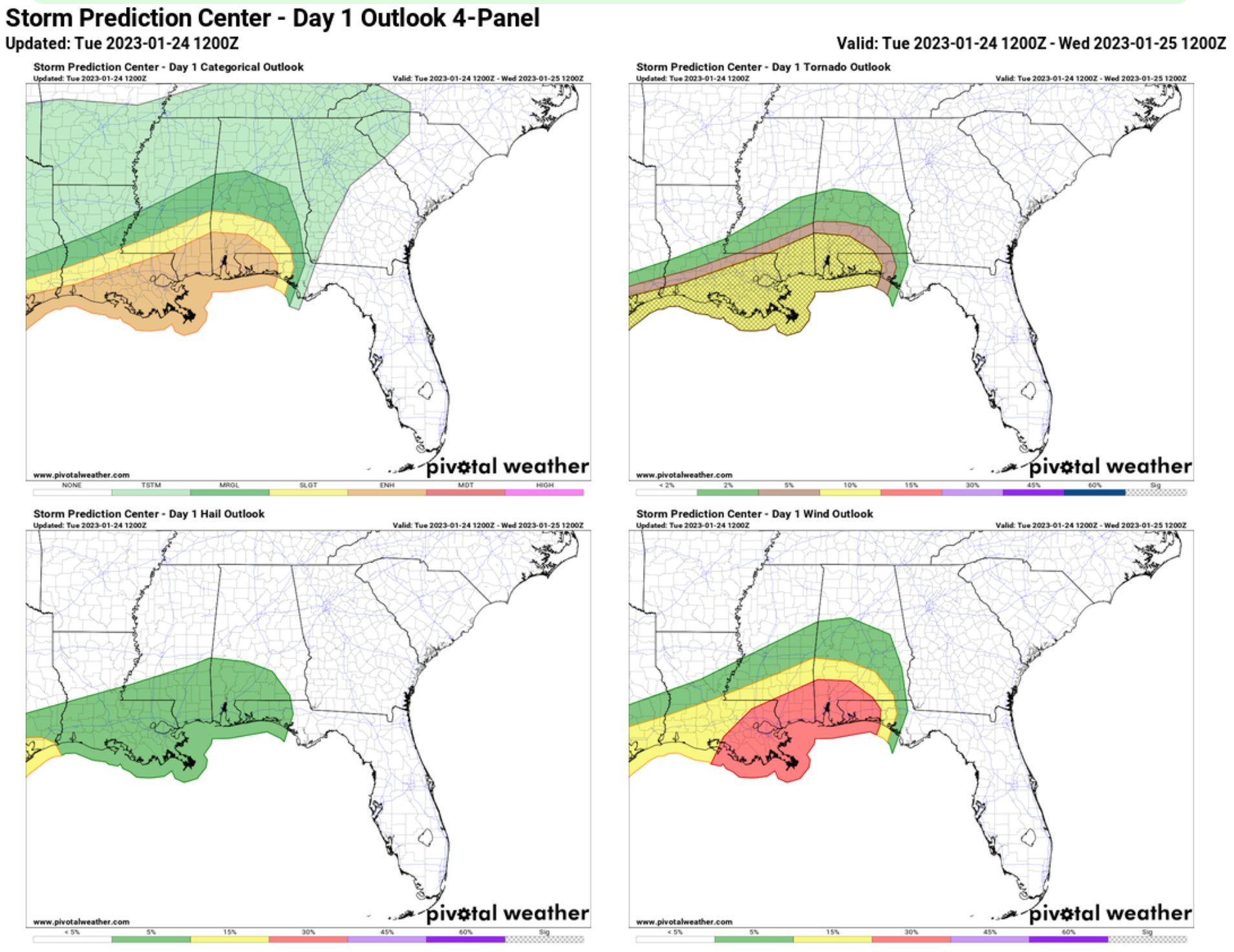
I tend to think the tornado threat will be closer to the coast. In fact, I would argue that the likelihood of tornadoes falls off pretty quickly once you get more than 75 miles from the Gulf.
But the wind? Everyone gets the wind. Here is a look at the wind gusts possible tonight around 9p. This isn’t wind in the storms. This is just the wind blowin’ because there is a storm system nearby.

This is why I said last night to, basically, treat this like a weak landfalling tropical system. Because the wind will be cruisin for a few hours leading to pockets of power outages and some downed trees. And that is before the storms arrive.
So please make sure you have a way to get alerted about severe weather and potential tornadoes that doesn’t require being plugged into a wall. A NOAA weather radio with good batteries in it, a good weather app that pings you with NWS Watches/Warnings, too, for example!
….. On your phone?
TAP HERE TO DOWNLOAD THE NICKELBLOCK FORECASTING APP FOR ANDROID
OR
TAP HERE TO DOWNLOAD THE NICKELBLOCK FORECASTING APP FOR APPLE
i will say that my app is still in “Beta” which means I would not rely on it to work 100% today since it is still being tested. But this will be a good test!
For more info about the forecast and a county-by-county breakdown of what to expect, check out my post from last night by clicking/tapping here!
REGIONAL DAY TO DAY FORECAST
Today
Partly sunny. A slight chance of showers this afternoon. Highs in the upper 60s. Southeast winds 15 to 20 mph. Gusts up to 40 mph this afternoon. Chance of rain 20 percent.
Tonight
Cloudy. Showers with thunderstorms likely. Some thunderstorms may be severe. Very windy. Lows behind the storms in the upper 40s. Southeast winds 25 to 35 mph, becoming southwest after midnight. Gusts up to 55 mph. Chance of rain near 100 percent.
Wednesday
Partly sunny. Highs around 60. West winds 15 to 20 mph with gusts up to 30 mph.
Wednesday Night
Mostly cloudy. Lows in the upper 30s. Northwest winds 10 to 15 mph with gusts up to 25 mph
.Thursday
Mostly sunny. Highs in the mid 50s. Northwest winds 10 to 15 mph with gusts up to 25 mph.
Thursday Night
Mostly clear. Cold with lows in the lower 30s.
Friday
Sunny. Highs in the mid 50s.
Friday Night
Mostly clear. Lows in the mid 30s.
Saturday
Mostly sunny. Highs in the lower 60s.
Saturday Night
Cloudy. A slight chance of showers after midnight. Not as cool with lows in the upper 40s. Chance of rain 20 percent.
Sunday
Showers likely. Highs in the mid 60s. Chance of rain 50 percent.
Sunday Night
Cloudy with a 50 percent chance of showers. Lows in the mid 50s.
Monday
Cloudy with a 20 percent chance of showers. Highs in the mid 60s.


This is at just past noon. Looks like the warm front is moving on up from the south and west. Will that make it better for us in south and east MS or worse? Wind is as calm as can be at this time.