Looking at some of the latest data today – both this morning and this afternoon – I’m starting to become a bit more concerned about the flooding threat for the area in the coming days. It looks like we will have multiple rounds of potential storms. The first showing up on Friday. A second on Monday/Tuesday. And perhaps a third on Wednesday.
In fact, looking at the CIPS Analogs severe weather data, it shows five of the next 8 days include the potential for severe weather across parts of the Southern MS/AL/LA region.

While most of that day-to-day risk has to do with timing of the storms, it also means that we need to pay attention to the timeline closely. And if you have plans on any particular day, it is important to watcht he weather forecast to make sure your plans don’t get washed out.
Round 1
Given the latest available data, this first round of storms the severe threat looks pretty limited, but it isn’t zero. So, as I like to say, ‘severe weather is possible, but not likely,’ and is something to consider and remember but not he biggest concern. Instead, flooding is looking likely, not just possible. The question isn’t “will it flood?” at this point, but “where will it flood?” and “How much will it flood?”
Thankfully, the numbers have come down a bit from where they were earlier this week. The NBM data was showing up to 10″ of rain possible between the next two systems. Not that number is closer to just 7″ in total.
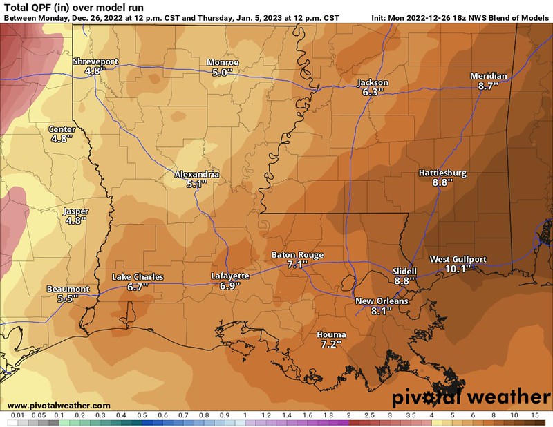

Still a lot of water, but a more manageable amount. The recent dry spell should help, too, even with the recent rains. But that won’t help us completely.
The Weather Prediction Center has highlighted the region with a potential for flash flooding in the coming days. They wrote: “An upper trough stationed over the Great Plains will continue focusing moisture from the Gulf of Mexico at the Central Gulf Coast and inland areas on Friday. There’s reasonable agreement regarding the axis of heaviest rainfall (1-3 inches) setting up along the Gulf Coast from eastern Louisiana to the Florida Panhandle and southwestern Georgia. PWATs between 1.5-2 inches and hourly rain rates ranging from 0.25-1in/hr may cause isolated instances for flash flooding. The heaviest rates will likely be within convective cells. Fortunately, higher flash flood guidance and low stream levels will mitigate a lot of the heavy rainfall.”

Currently the SPC doesn’t have the area outlined with any “Risk” on it’s map, but I anticipate them adding a MArginal Risk for severe weahter for areas close to the Gulf in the coming days.

Again, a situation where severe weather is possible, but certainly not likely.
Round 2
Then, just a few days later the CIPS Analogs data suggest another 2″ to 4″ rain event on January 2nd/3rd.

That would likely lead to more potential flooding given the soaked ground.
On top of that, the same Jan 2nd/3rd event also shows the potential for a few severe storms, too.

Given this data, we may also have to worry about the potential for strong wind and tornadoes along with the flooding risk. The SPC has already pegged sections of the region with a Slight Risk for severe weather during this time period. That is a “2” on the 1-to-5 scale where “5” is the highest risk for the most significant severe weather.

The SPC writes: “The EC run-to-run consistency has increased confidence in a potential severe episode. Very strong flow through the troposphere and a moist/conditionally unstable airmass will potentially be favorable for severe activity (i.e., risk for damaging winds and tornadoes) from the Arklatex Monday afternoon into the lower MS Valley Monday evening/night and north-northeastward into the lower OH Valley late Monday night.”
And it is worth noting that the CIPS Analogs data shows that 1/3rd of the top 15 analogs to the Jan 2/3 event feature at least one long-track tornado in the region. So this next system may be one worth paying closer attention to as we get closer. The hope is that the data flips for us and things get a bit more innocuous. But for the moment, this next one is definitely on our radar.
The Bottom Line
Storms will be possible on Friday and then again next Monday/Tuesday. Some of the storms may be severe, particularly next week. Flooding is a concern with both rounds.
Keep tabs on the weather forecast in the coming days and check back on the blog for updates. Often my morning forecasts may lack this type of depth, but I will always do my best to keep you guys ahead of the weather and offer as much detail as I can to get you prepared.


